Weather Blog Post
Last Updated: Mar 20, 2020 12:31 AM
Not a subscriber? Go to www.weathertalk.com/welcome
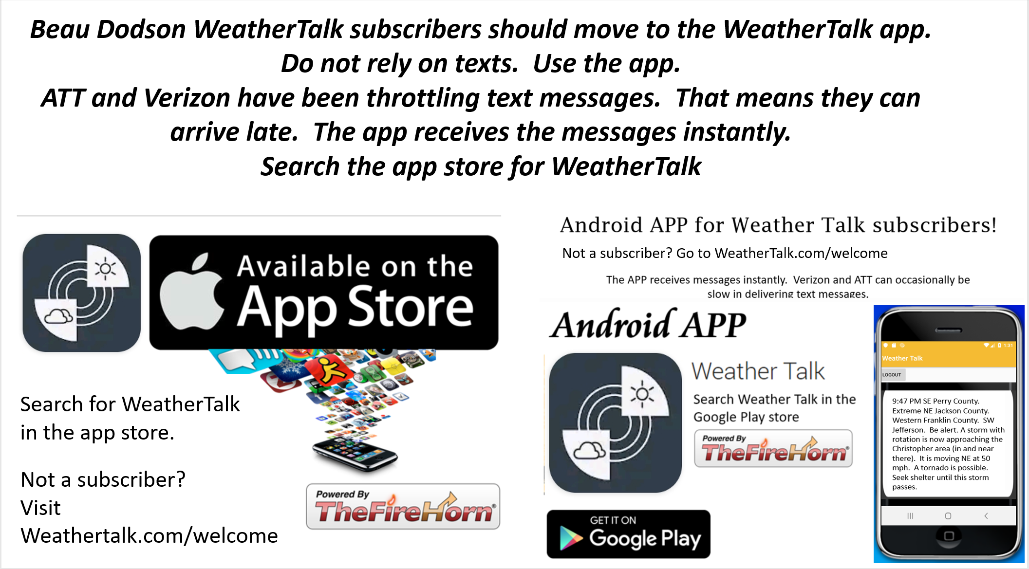
Subscribe to Weather Talk. Then go to the app store and download it. Search for Weather Talk or Beau Dodson Weather. Apple users click here. Android users click here

.
What you need to know.
Key Points
- Severe thunderstorms are likely later today and tonight.
- This could be an all-night event. Have three to five ways of receiving your severe weather information. That includes my Beau Dodson Weather Talk app and a NOAA Weather Radio.
- Tornadoes at night tend to cause more deaths. This is mainly because people are sleeping.
.
Call to action.
Monitor updated weather forecasts.
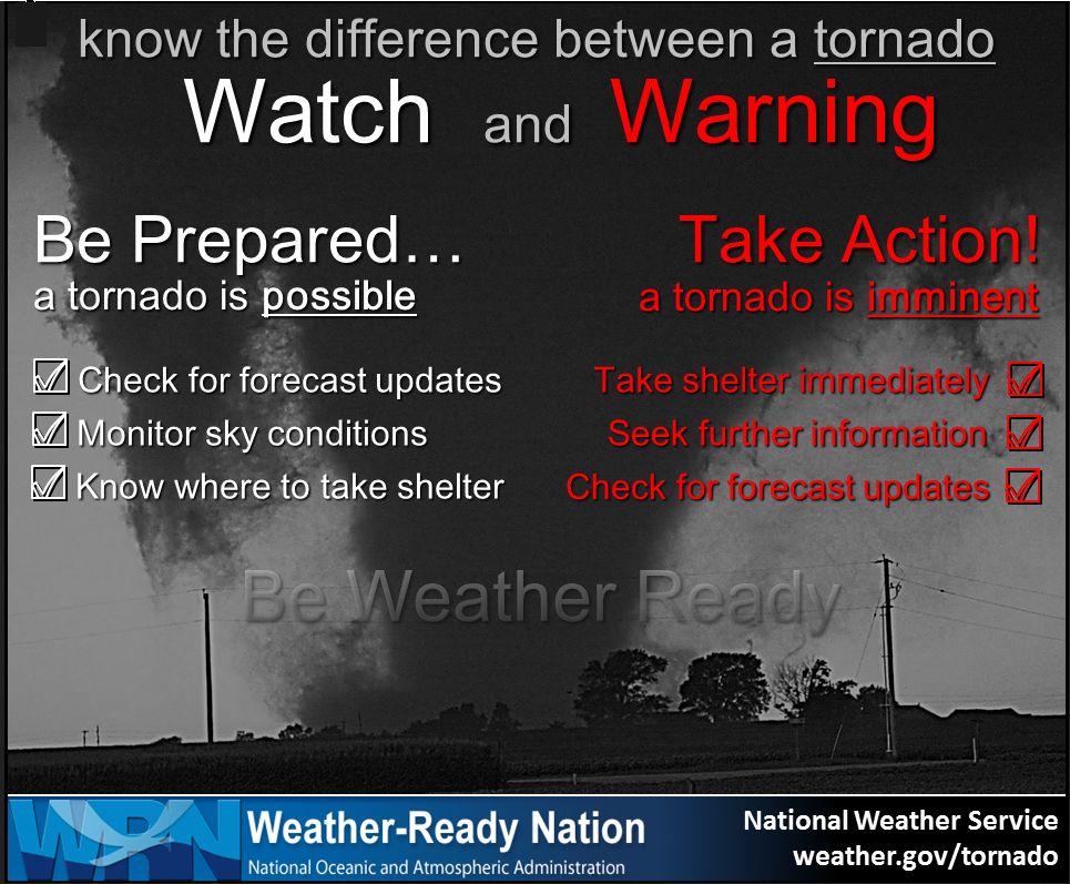
Remember, a watch means that conditions are favorable for severe thunderstorms to form.
A warning means to take action. Seek shelter. A warning is more serious than a watch.
Make sure you are using the Weather Talk app. Download it from the app store. It is under Weather Talk.
TURN IT ON. Make sure it is on. Make sure you have not accidentally logged out of the app.
The app is for subscribers (please log into your account and make sure your payment has been updated. We have a large number of declined cards and PayPal payments). Subscribe at www.weathertalk.com/welcome then go to your app store and search for WeatherTalk. Apple users click here. Android users click here
.
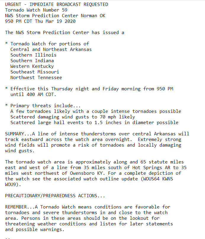
Thursday and Friday. March 19th and 20th.
12:17 AM
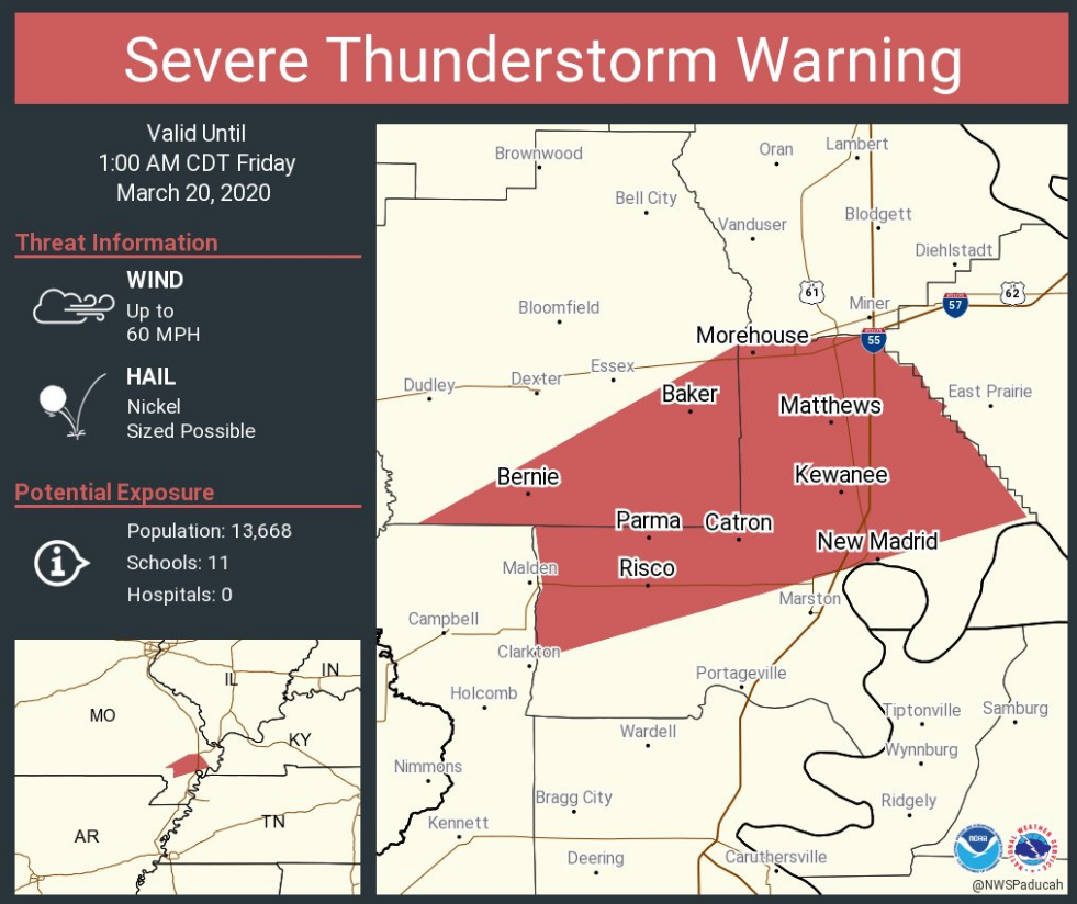
Storm moving through northern Dunklin County could produce 60 mph wind gusts. It is moving NE at 55 mph and will exit the county within the next 15 minutes.
.
12:08 AM
Southern Stoddard, eastern Stoddard, New Madrid, southern Scott, Mississippi. Storms moving into Stoddard and New Madrid County have become severe.
Wind gusts above 60 mph are possible. Hail, as well.
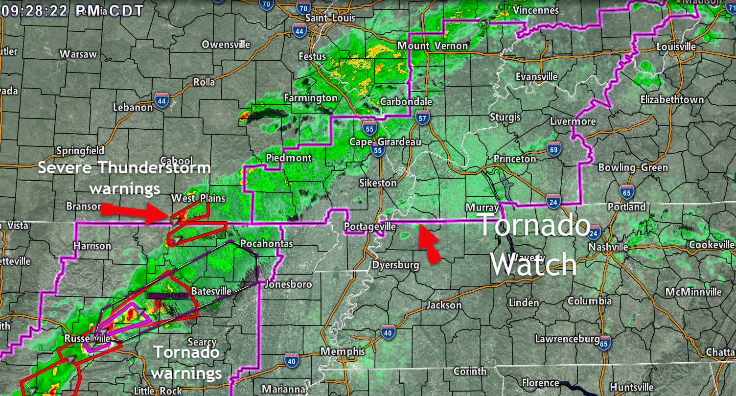
There is a tornado watch so let's be alert as these storms race off to the NE at 55 mph.
Radar http://weatherobservatory.com/radar_pbluff.htm
.
12:01 AM
.
11:55 PM
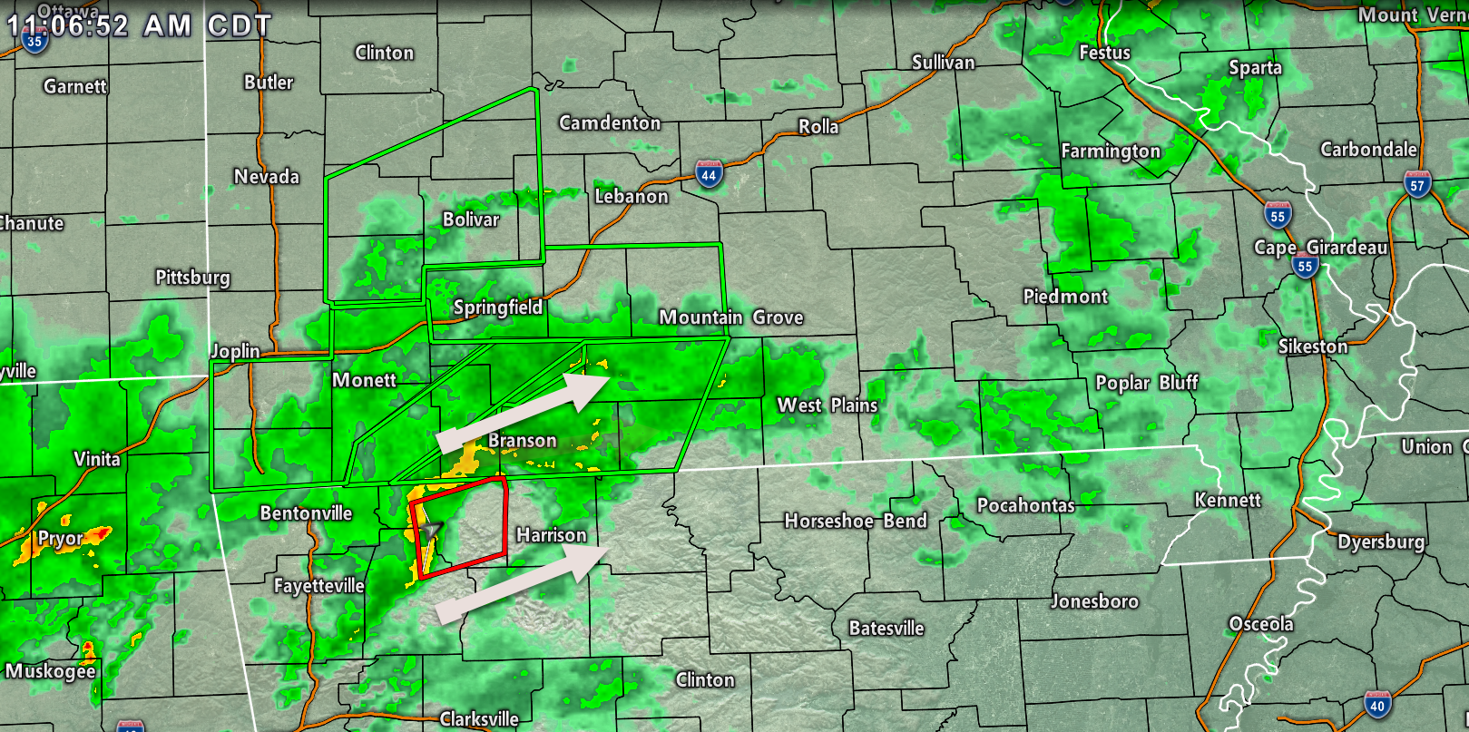
Live radar link http://weatherobservatory.com/radar_pbluff.htm
.
10:07 PM
.
.
9:52 PM
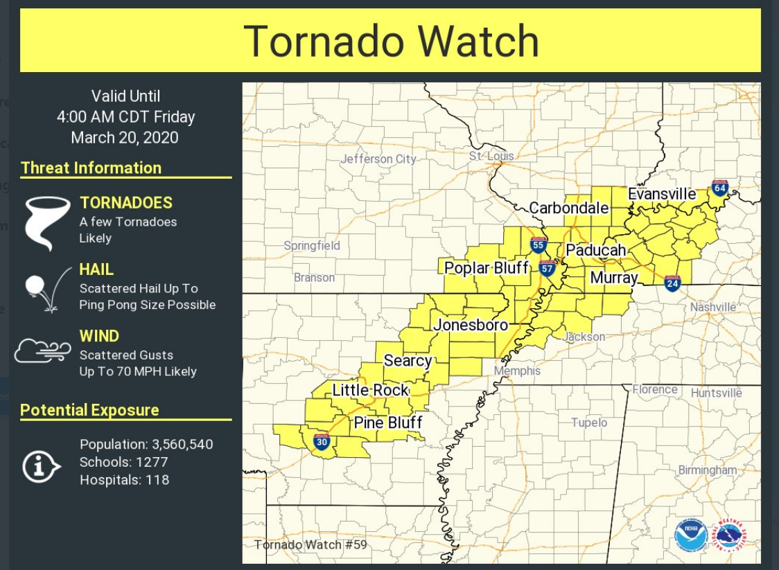
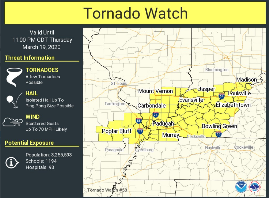
A new tornado watch has been issued until 4 am.
..
.
9:30 PM
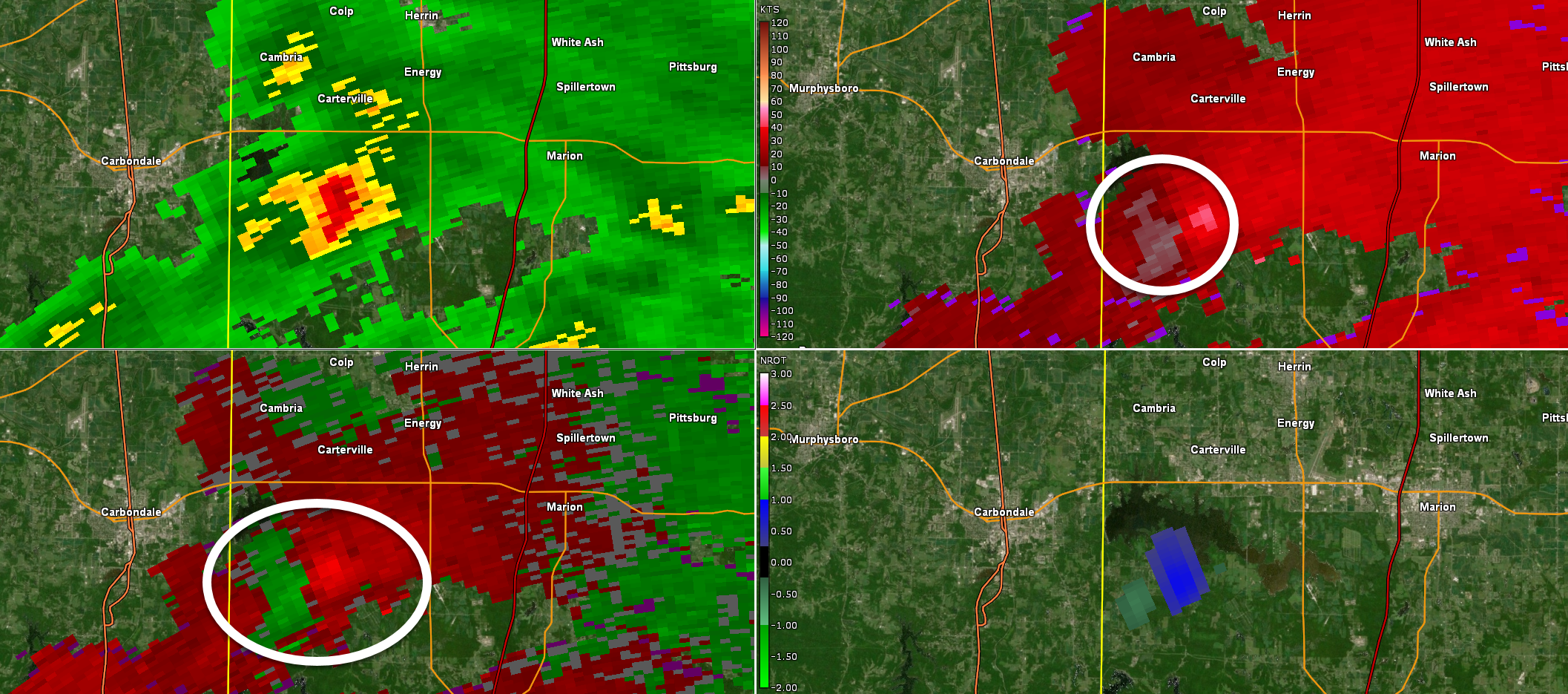
Severe thunderstorms are moving northeast out of Arkansas and southern Missouri.
These are the storms to watch over the coming three to six hours.
8:43 PM
These storms will continue to move northeast through the overnight hours.
.
7:30 PM
We are in a lull. More storms will develop as we move through the coming hours.
Some will be severe.
Late report
Local Storm Report by NWS PAH: Dahlgren [Hamilton Co, IL] public reports TSTM WND DMG at 04:25 PM CDT -- 2 homes with roof decking removed, 2 barns damaged, and numerous trees and power lines down.
.
6:17 PM
The small supercell in Williamson County, IL has weakened. Let's pay attention through the night.
Severe storms are possible well into the night (even past midnight). A tornado watch remains in effect. A watch means to monitor updates. A warning is more serious. A warning means to seek shelter immediately.
.
6:07 PM
Storm continues to move northeast through Williamson County, IL. Some rotation with it. Let's be alert.
.
5:55 PM
Extreme SE Jackson County and Williamson County. A storm near Makanda was moving NE at 55 mph. It has some rotation. Storms earlier tonight, similar to this one, produced wind damage. Be alert as this storm moves towards Marion, IL.
.
5:19 PM
Storms may form at any given point tonight. Otherwise, let's watch the storms coming out of Arkansas.
.
5:11 PM
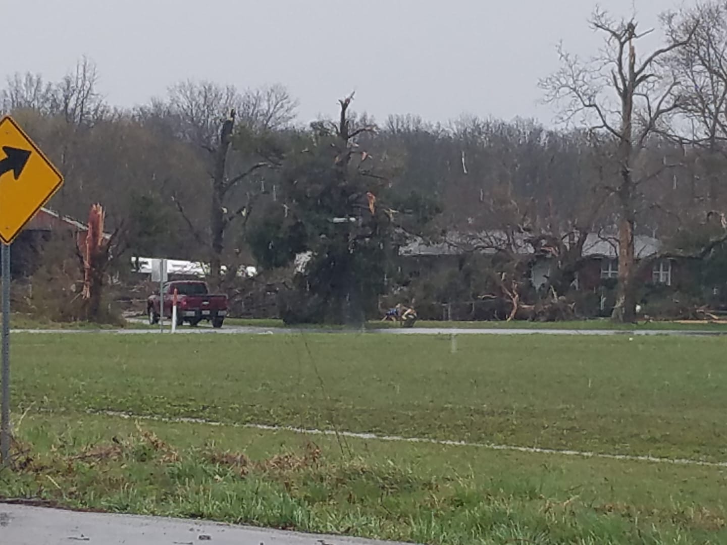
Update on damage from earlier this evening.
Local Storm Report by NWS PAH: 2 N Saint Johns [Perry Co, Illinois] emergency manager reports thunderstorm wind damage at 03:43 PM CDT -- narrow damage path in Sunfield IL. 12-15 houses damaged, 4 with major structural damage, 10 with roof damage, garage destroyed. numerous power poles and trees down. Camper trailers were blown across a field.
Sara Colvin photographer near Sunfield, IL. Tornado damage.
.
4:48 PM
The rotation has moved out of Hamilton County.
Other storms are moving through the county. Those storms could produce strong and gusty winds.
These storms will soon move into White County, IL, as well.
Radar http://weatherobservatory.com/radar_evans.htm
.
4;45 PM
Local Storm Report by NWS PAH: Dahlgren [Hamilton Co, IL] law enforcement reports TSTM WND DMG at 04:25 PM CDT -- tree and pole pole blown down in dalhgren. time estimated.
Local Storm Report by NWS PAH: 3 ESE Woodlawn [Jefferson Co, IL] public reports FLASH FLOOD at 04:37 PM CDT -- highway 15 flooded between woodlawn and mount vernon. relayed via twitter.
.
4:30 PM
Jefferson County. The tornado threat has ended in your county.
.
4:29 PM
.
4:25 PM
Rotation is about to move out of SE Jefferson County. It is moving into northwest Hamilton County. A tornado is possible.
A tornado was reported with this storm earlier this afternoon.
The main area of rotation was near Dahlgren. In and near that area. Perhaps a tad north of that town. it is moving northeast at 60 mph.
Seek shelter if you are in the path of this possible tornado.
.
4:18 PM
BULLETIN - EAS ACTIVATION REQUESTED
Flash Flood Warning
National Weather Service Paducah KY
417 PM CDT Thu Mar 19 2020
The National Weather Service in Paducah has issued a
* Flash Flood Warning for...
Wayne County in south central Illinois...
Wabash County in southeastern Illinois...
Edwards County in southeastern Illinois...
* Until 1015 PM CDT.
* At 417 PM CDT, Doppler radar indicated thunderstorms producing
heavy rain across the warned area. Up to one inch of rain has
already fallen. Flash flooding is ongoing or expected to begin
shortly.
HAZARD...Flash flooding caused by thunderstorms.
SOURCE...Radar indicated.
IMPACT...Flooding of small creeks and streams, urban areas,
highways, streets and underpasses as well as other
drainage and low lying areas.
* Some locations that will experience flooding include...
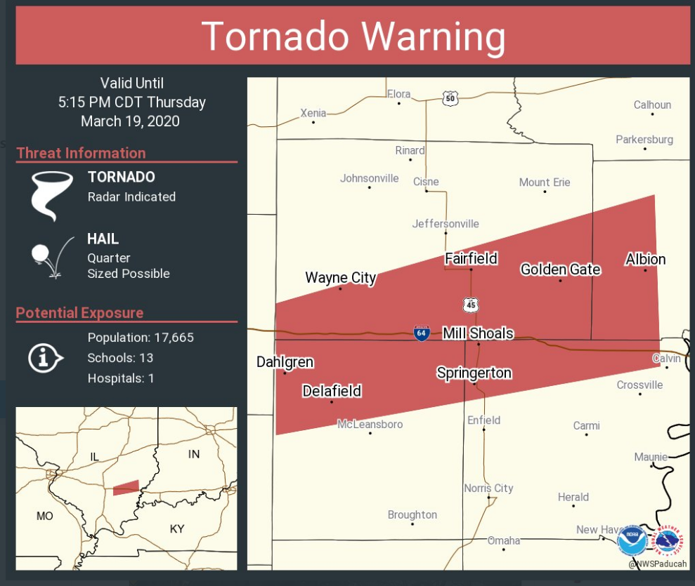
Mount Carmel, Fairfield, Albion, Grayville, Lancaster, Wayne City,
West Salem, Cisne, Allendale, Jeffersonville, Bellmont, Sims, Bone
Gap, Keensburg, Browns, Mount Erie, Keenes, Johnsonville and Golden
Gate.
Additional rainfall amounts of up to one inch are possible in the
warned area.
.
4:15 PM
.
4:09 PM
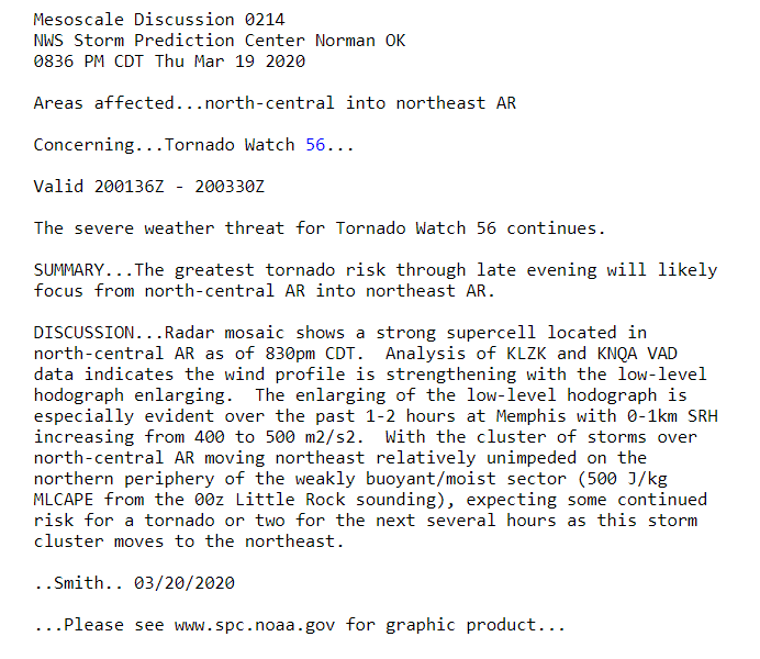
Southern Jefferson, northwest Hamilton, and northeast Franklin. Radar showed rotation near Ina, IL moving NE at 55 mph. Those in the path of this storm should seek shelter. A tornado is possible.
The rotation has increased in intensity over the last 10 minutes.
Rotation near Ina (I circled it)
.
4:07 PM
Lyon, Caldwell, Trigg, Hopkins, McLean, Muhlenberg, Christian, and Todd Counties. Storms are forming over west KY and moving northeast at 55 mph. Some of these storms have produced isolated wind damage.
The storms are embedded in a solid area of rain.
Some of these storms, over the next hour or so, could produce pockets of 55 mph wind.
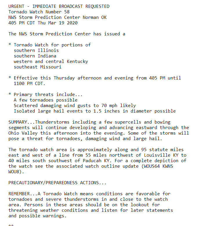
A tornado watch will be in effect for your area until 11 pm. A watch means to stay alert. A warning is more serious. A warning means to seek shelter.
.
4 PM
Local Storm Report by NWS PAH: 1 NE Du Quoin [Perry Co, IL] public reports TSTM WND DMG at 03:53 PM CDT -- report from mping: 1-inch tree limbs broken; shingles blown off.
.
4 PM
Hamilton, White, Williamson, Saline, and Gallatin Counties. A line of storms is approaching from the west. This line is moving northeast at 55 mph. See the radar links below.
Occasionally, these storms have been producing isolated high wind. Torrential rain is being reported under the heavier cells.
There is some spin in the atmosphere this evening. Some of these storms occasionally show rotation. The rotation has mainly been broad and not tight.
Additional heavy storms are likely tonight. Some storms could be severe. Monitor updates.
Radars http://weatherobservatory.com/weather-radar.htm
Backup radars https://weathertalk.com/morani
.
3:57 PM
The tornado threat has ended for Perry County (for now). Jefferson and northern Franklin County remain in a tornado warning. There haven't been any reports of wind damage or tornadoes. This is a radar indicated tornado. Rotation is not tight. It is broad.
The tornado warning includes the Rend Lake area, Sesser, Valier, Ina, North City, Waltonville, Bonnie, Ewing, and Nason. In and near those locations.
Seek shelter until the storm passes. There is a low-end tornado risk.
Avoid flooded roadways, as well.
.
3:53 PM
BULLETIN - EAS ACTIVATION REQUESTED
Flash Flood Warning
National Weather Service Paducah KY
353 PM CDT Thu Mar 19 2020
The National Weather Service in Paducah has issued a
* Flash Flood Warning for...
Perry County in south central Illinois...
Jefferson County in south central Illinois...
* Until 700 PM CDT.
* At 352 PM CDT, trained weather spotters reported flash flooding on
Highway 154 in Pickneyville. Up to one inch of rain has already
fallen. Flash flooding is already occurring.
HAZARD...Flash flooding caused by heavy rain.
SOURCE...Trained weather spotters.
IMPACT...Flooding of small creeks and streams, urban areas,
highways, streets and underpasses as well as other
drainage and low lying areas.
* Some locations that will experience flooding include...
Mount Vernon, Du Quoin, Pinckneyville, Rend Lake Area, Woodlawn,
Bluford, Tamaroa, Willisville, Ina, Cutler, Waltonville, Bonnie,
Belle Rive, Nason and St. Johns.
.
3:48 PM
.
3:44 PM
Red box is a severe thunderstorm warning.
Pink zone is the tornado warning. Storm is moving northeast at 55 mph.
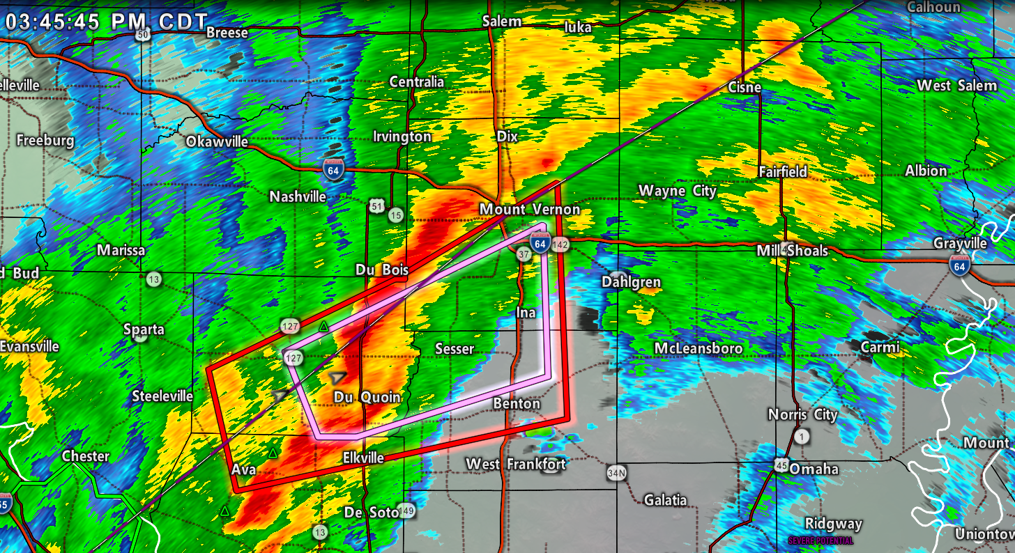
Update. Radar shows rotation near Sunfield, IL. That is between Tamaroa and Du Quoin. There are several areas of rotation within this storm.
It is moving northeast at 55 mph. The storm could produce a tornado. There haven't been any reports of wind damage or tornadoes. This is a radar indicated tornado.
.
3:41 PM
Jackson County. You are clear from any tornado concerns. Additional storms are possible tonight. Monitor updates.
.
3:33 PM
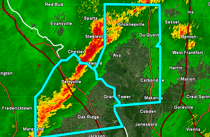
Radar some rotation in northern Jackson County. The rotation is not all that tight. There is, however, enough rotation to warrant a tornado warning. The rotation will move towards Du Quoin, Pinkneyville, Rend Lake area, Sesser, Valier, Tamaroa, Ina, North City, Waltonville, Bonnie, Ewing, Nason, and St. Johns. In and near those areas. Seek shelter until this storm passes.
Radar https://imagery.weathertalk.com/morani/mtvn50/morani.html
.
3:30 PM
Perry County, IL. SW Jefferson County. NE Jackson County. Northern Franklin County. A line of intense thunderstorms is pushing across portions of southern IL. These storms could produce pockets of wind damage. There is a low-end tornado risk, as well.
The storms are moving northeast at 55 to 60 mph.
Radar http://weatherobservatory.com/radar_mtver.htm
.
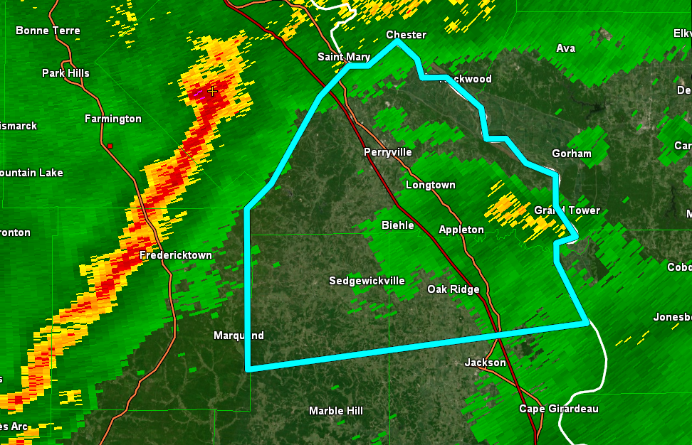
3:18 PM
PAH issues Flash Flood Warning for Bollinger, Perry [MO] till 6:15 PM CDT
.
3:10 PM

.
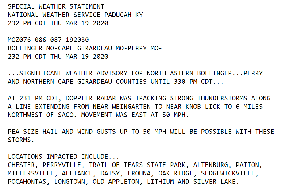
2:34 PM
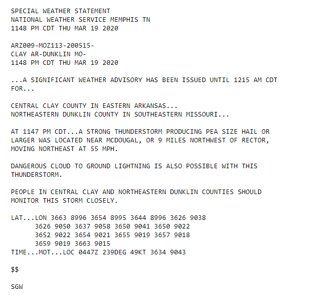
SIGNIFICANT WEATHER ADVISORY FOR
NORTHEASTERN BOLLINGER, PERRY AND NORTHERN CAPE GIRARDEAU COUNTIES UNTIL 330 PM
.
2:31 PM
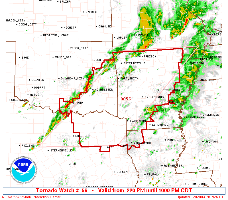
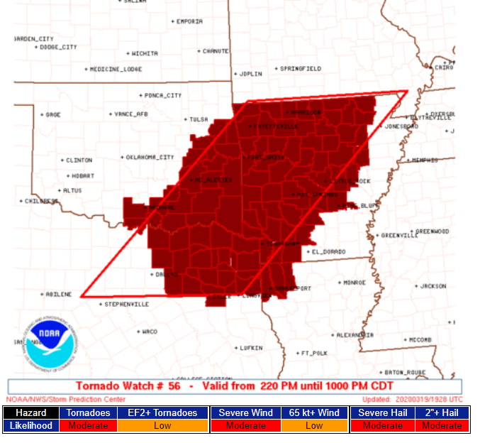
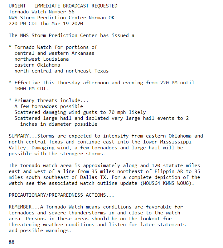
A tornado watch to our southwest.
.
2:30 PM
Flash flood update.
.
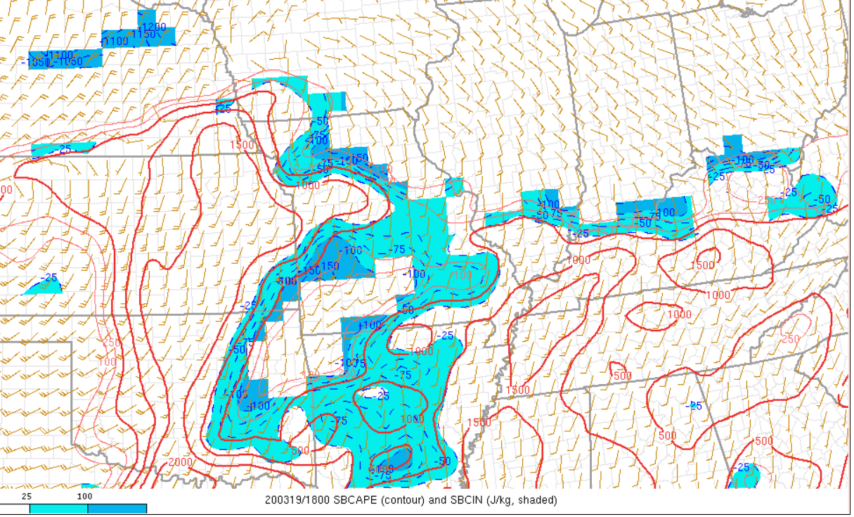
1:32 PM
We have CAPE. CAPE is an ingredient in the severe weather mix. Clouds have helped keep CAPE lower. It has not stopped it from forming.
Severe storms are increasingly likely as we move through the afternoon and evening.
.
1:22 PM
I am monitoring storms in southern Missouri and Arkansas. Currently, as of this typing, they are intense but not severe.
Blue boxes are for strong storms, but sub-severe. See the live radar link
A new regional radar we offer
https://imagery.weathertalk.com/prx/RadarLoop.mp4
Interactive city-view radars
http://weatherobservatory.com/weather-radar.htm
.
11:12 AM
.
1:10 AM
Severe thunderstorms are forming over northern Arkansas and southern Missouri.
These will be the storms to watch over the coming hours.
They are moving northeast.
A new regional radar we offer
https://imagery.weathertalk.com/prx/RadarLoop.mp4
.
10:00 AM
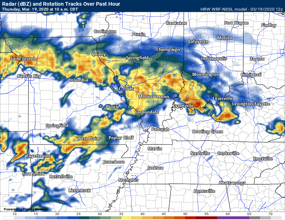
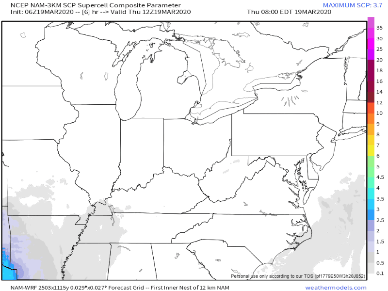
This is the SPC WRF model future-cast radar. It is more concerning. It does show a lull in the rain and then supercells move out of AR into our region.
Click to enlarge this animation. Time-stamp upper left.
.
9:47 AM
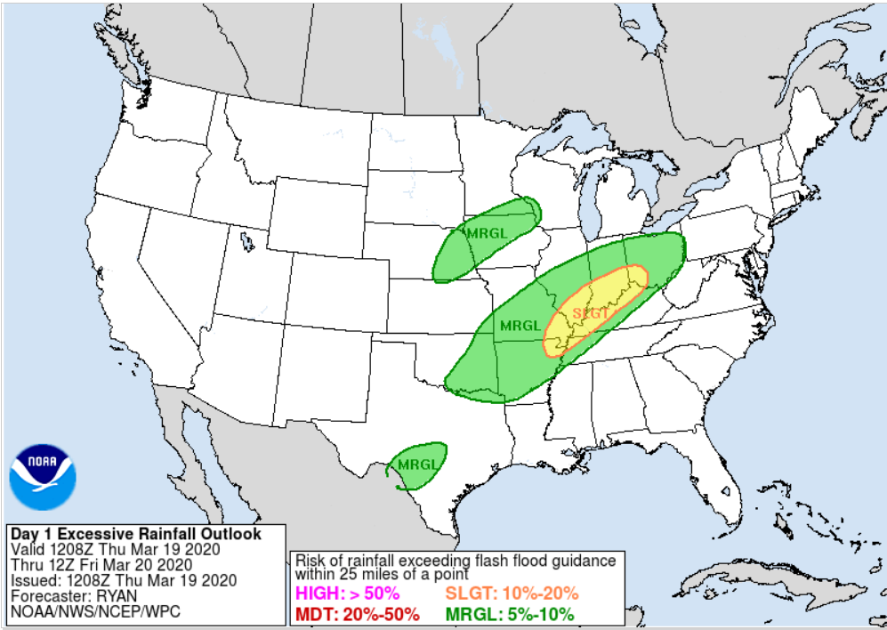
We are in a marginal and slight risk of excessive rainfall today and tonight. What does that mean? It means that we may have enough rain to trigger flash flooding.
Avoid flooded roadways. A flash flood watch blankets the region.
.
9:30 AM
Morning data shows showers and storms continuing on off all day over parts of SE MO and south IL. This raises questions on the placement of severe weather parameters.
Note here:
See where the colors end. That is where the air is more stable. The colors are unstable air.
.
9 AM Update
What could interfere with the forecast?
If clouds and rain linger longer than anticipated then instability will be lower. That would work in our favor. This is one part of the forecast that has some uncertainty. It seems that is usually the case.
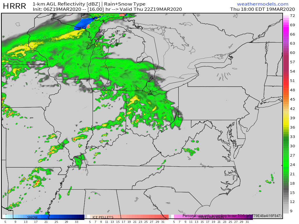
Here is the latest Hrrr future-cast radar. Click to enlarge.
This is what this particular model believes will happen. Keep in mind, it is just a model. The Hrrr model does well with thunderstorm events.
Don't take the exact location of the storms. Take a general idea. Several rounds of thunderstorms are possible with this event. It may last well into the night.
.
8 AM update
Severe Thunderstorms Thursday and Thursday night/Friday morning
Here is the bottom line.
LOG in to your app. Make sure you have not accidentally logged out of the Weather Talk app.
Severe thunderstorms are likely to develop this afternoon and tonight. Large hail, damaging wind, and tornadoes will be possible. Remember, a watch means to monitor updates. A warning means to take shelter. A warning is more serious. A warning means that severe weather is imminent in or near your location.
Be sure and make sure you are logged into the app. Open it. Make sure it is on.
Our widespread morning showers and thunderstorms will end. Then, a semi-lull. The radar won't be completely void of showers/storms, but coverage will decrease over the coming hours.
Then, thunderstorms will redevelop as we move into the afternoon and overnight hours. This is when the severe weather threat increases.
Peak severe weather parameters will arrive between 3 PM and 3 AM.
This event should last past midnight.
Keep in mind, as with nearly every severe weather event, there remain some questions.
The main question centers around how unstable the atmosphere will become later today. It appears that there will be sufficient instability for concerns.
Wind shear will pick up this afternoon and tonight. There are strong indicators that wind shear will be sufficient for tornadoes. As always, it only takes one tornado to cause problems.
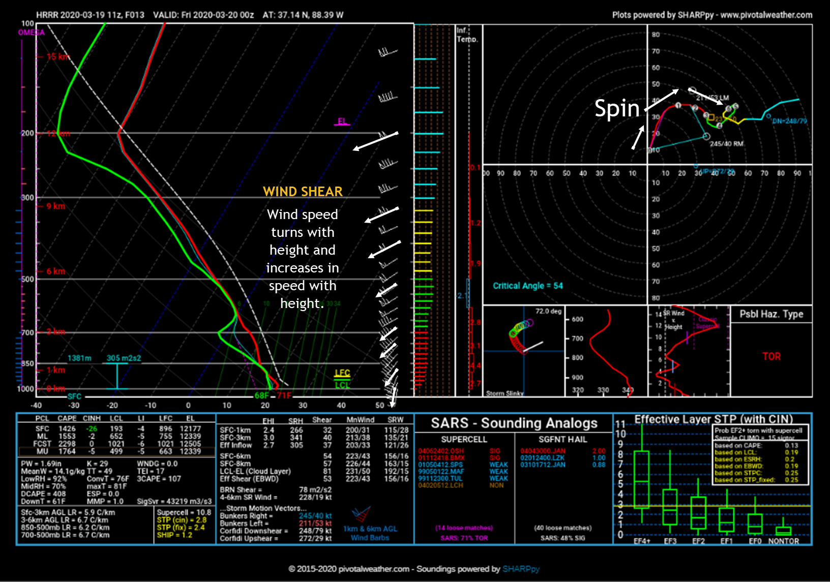
Meteorologists look at soundings when forecasting the weather. Think of a sounding as a slice of the atmosphere. The bottom of the sounding is ground level. Then, move higher on the graphic and you move up in the atmosphere.
This sounding shows wind shear. Those arrows on the right are wind direction and speed. The wind changes direction with height and increases in speed. Again, that is called wind shear.
Click to enlarge. I made some notes on the graphic. This is a severe weather sounding. It shows the potential of severe thunderstorms later today and tonight.
.
Forecast discussion
We have widespread showers and thunderstorms in the region this morning. See radars. This precipitation is moving north and northeast. It will move out of the area by late morning.
Here is the 7:40 AM radar. Static shot. Widespread rain and thunderstorms. This has caused the ground to become saturated.
A flash flood watch covers the area through tonight. Additional rain could cause issues. Avoid flooded roadways.
** Radars ** Link: Interactive local city-view radars & regional radars.
We will have a semi-lull in the shower and thunderstorm activity by late morning and early afternoon. It may not completely end but it won't be as widespread as what is happening this morning.
Then, thunderstorms will redevelop ahead of a cold front this afternoon into tonight. This is when the severe weather threat increases.
As mentioned above, there will be plenty of wind shear. Wind shear is an ingredient in severe weather.
Wind shear has two components. Speed shear and directional shear. Speed shear is when winds increase with height. Directional shear is when the wind turns with height. Those two ingredients help thunderstorms vent and become severe.
There will be no lack of wind shear with this system. High wind shear numbers are a concern. That is especially true by late afternoon into the overnight hours.
Thunderstorms should produce hail, damaging wind, and tornadoes. Make sure you are using the Weather Talk app.
Ingredients.
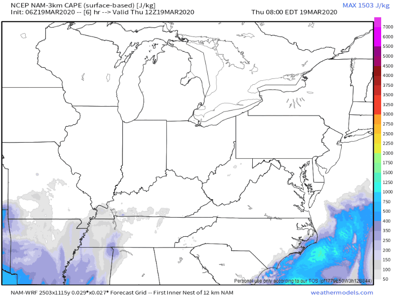
Here is the CAPE animation. CAPE is basically energy for thunderstorms to tap into.
Notice how this goes well into the overnight hours. The animation is in Zulu time. 00z = 7 pm. 06z = 1 am. 12z = 7 am. 18z = 1 pm.
The NAM model shows enough CAPE for severe weather concerns. Can you find the cold front? That is where you see colors end. It sweeps west to east late tonight.
.
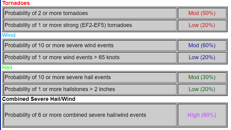
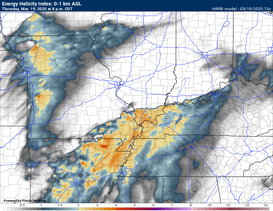
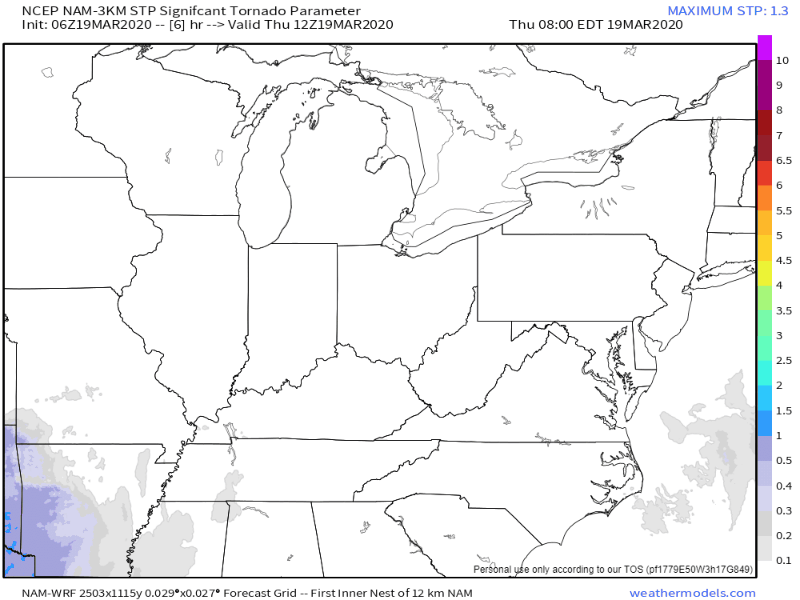
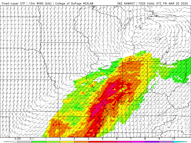
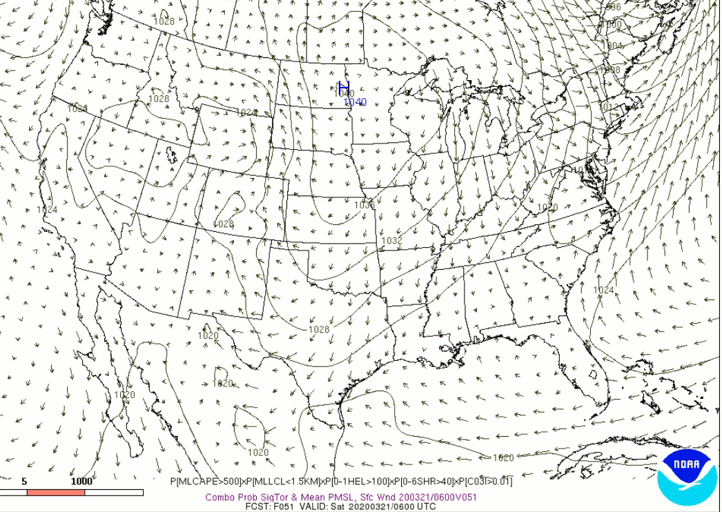
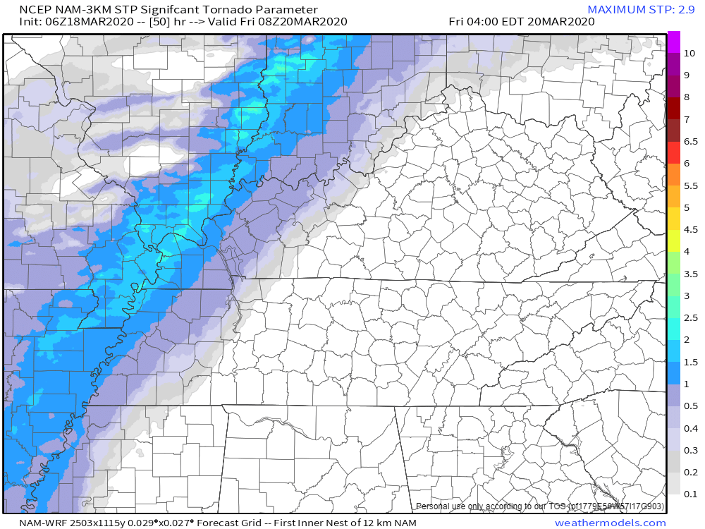
Here is the STP forecast for Thursday evening. The STP forecast is a tornado ingredient graphic. You can see that we have decent numbers across most of the area.
What does that mean? It means there will be wind shear. There will be a spin in the atmosphere. If thunderstorms develop then they could become severe. A few of the storms could even produce a tornado.
.
Often times, we have a solid line of thunderstorms along a cold front. Then, you can have thunderstorms ahead of the line. We call those supercells. Supercells can produce higher-end large hail, very high wind gusts, and tornadoes.
There are cases where supercells are embedded in lines, as well.
This is likely to be a mixed-mode event. There should be some supercell activity and a line of thunderstorms. Both. Both can produce severe weather.
Supercells are possible tomorrow afternoon and night.
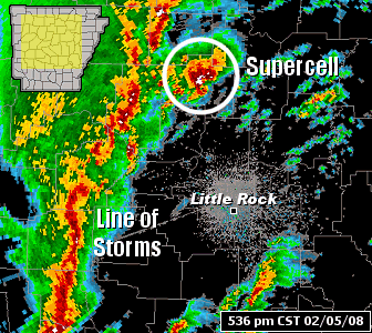
A squall line is a line of storms. Supercells tend to be ahead of the squall line or spotty in nature.
Example of a squall line and supercell.
.
Squall line. Line of storms. Notice the top of the graphic. The storms ahead of the line? Storms like that are usually supercells.
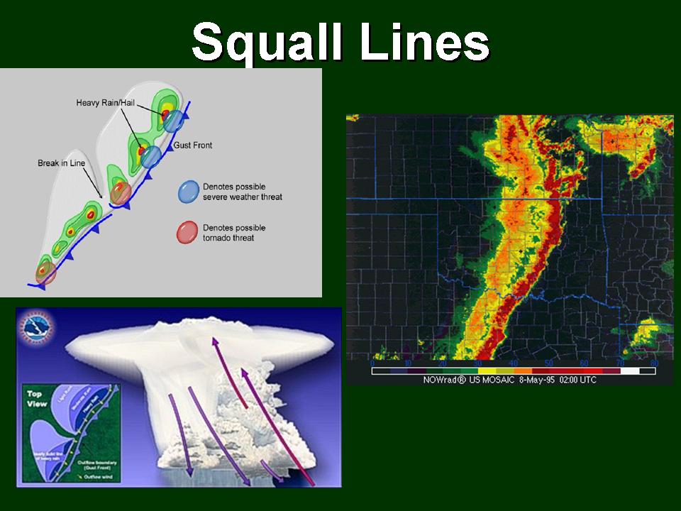
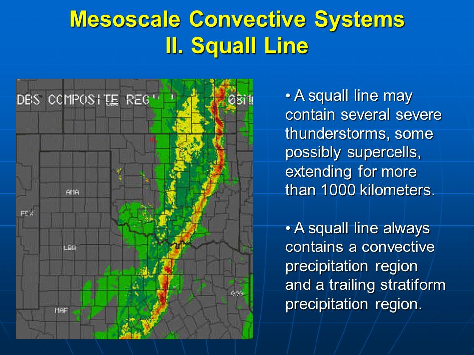
Squall lines tend to product damaging wind and can have short-lived tornadoes embedded within them.
Supercells tend to produce longer tracked tornadoes. Larger hail. High wind gusts.
Both squall lines and supercells can produce damaging tornadoes.
.
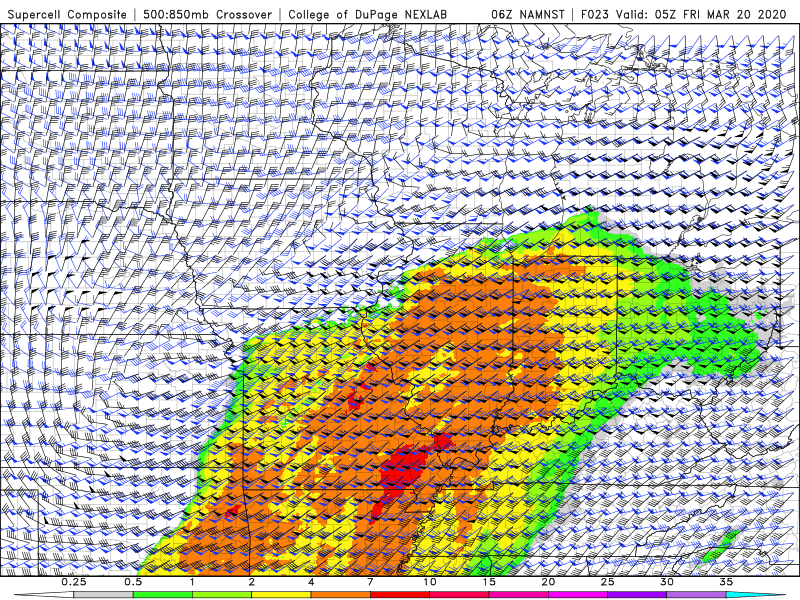
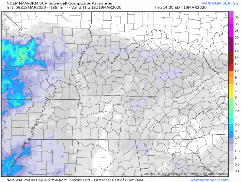
Let's look at the supercell composite parameter graphic. Supercells are typically lone thunderstorms that are away from a line of thunderstorms. In other words, supercells tend to be isolated. Perhaps not 100% isolated, but definitely more scattered in nature.
I wanted to show you this graphic because it shows you that we do have the ingredients for severe weather Thursday afternoon and night. Once again, you can see how those colors end behind the cold front as it moves west to east.
.
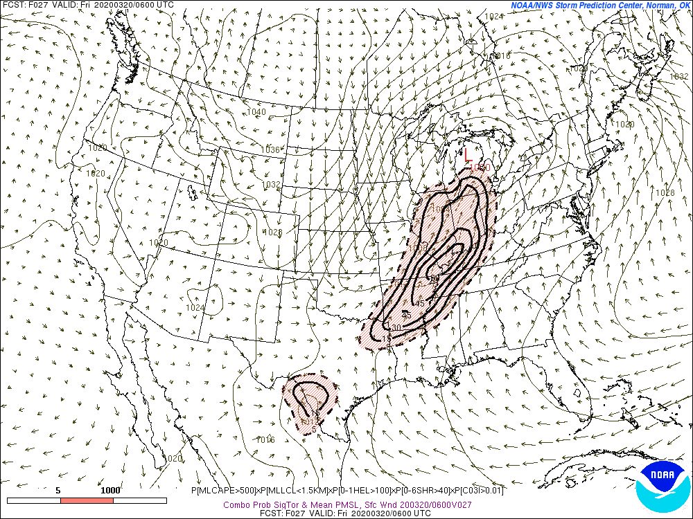
Here is the 12 AM STP graphic. Again, STP is a tornado indicator. This is late at night. That raises concerns.
We may have severe weather well into the overnight hours. Please make sure you have multiple ways of receiving warnings. Just in case a tornado does develop.
The 2 AM numbers increase. Again, this is a concern.
If this verifies then we could have tornadoes after midnight, as well. As always, have a way to receive warnings.
Hopefully, the models are wrong and we miss out on the tornadoes. Plan on severe weather.
Let's look at one model (see additional future-cast radars further down in the blog update).
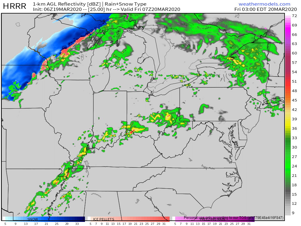
Here is what the Hrrr model shows for 1 PM today. Scattered storms forming in the region. We will need to monitor these storms as they form and move east/northeast at 55 mph.
6 PM Hrrr model future-cast radar. Scattered showers and thunderstorms in the region.
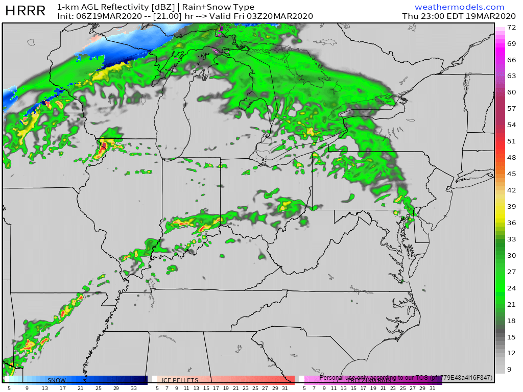
2 AM Hrrr model future-cast radar. A line of showers and thunderstorms.
.
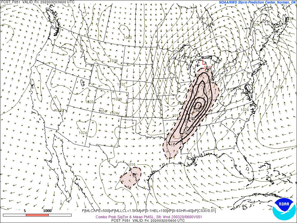
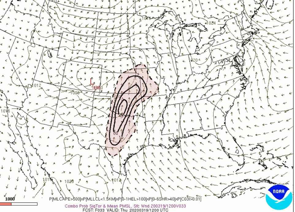
This next graphic is from the SREF model.
These are high numbers for Thursday afternoon into early Friday morning (very early Friday morning - before sunrise).
This raises concerns. If this does verify then we would have a tornado threat into the wee morning hours of Friday. That would be while most people are sleeping.
This is the tornado ingredient graphic. What does it mean? It simply tells me that there is a chance of tornadoes. The bullseye is over our region.
Keep in mind, as always, these are models. Models are not perfect. They are used for guidance. This is one of many graphics that I monitor and input into my forecast.
Multiple data-sets indicate there could be a tornado in our region later today and tonight.
.
This is the tornado ingredient animation. This takes us through Thursday afternoon and Thursday night. The concerns peak on Thursday afternoon and night.
.
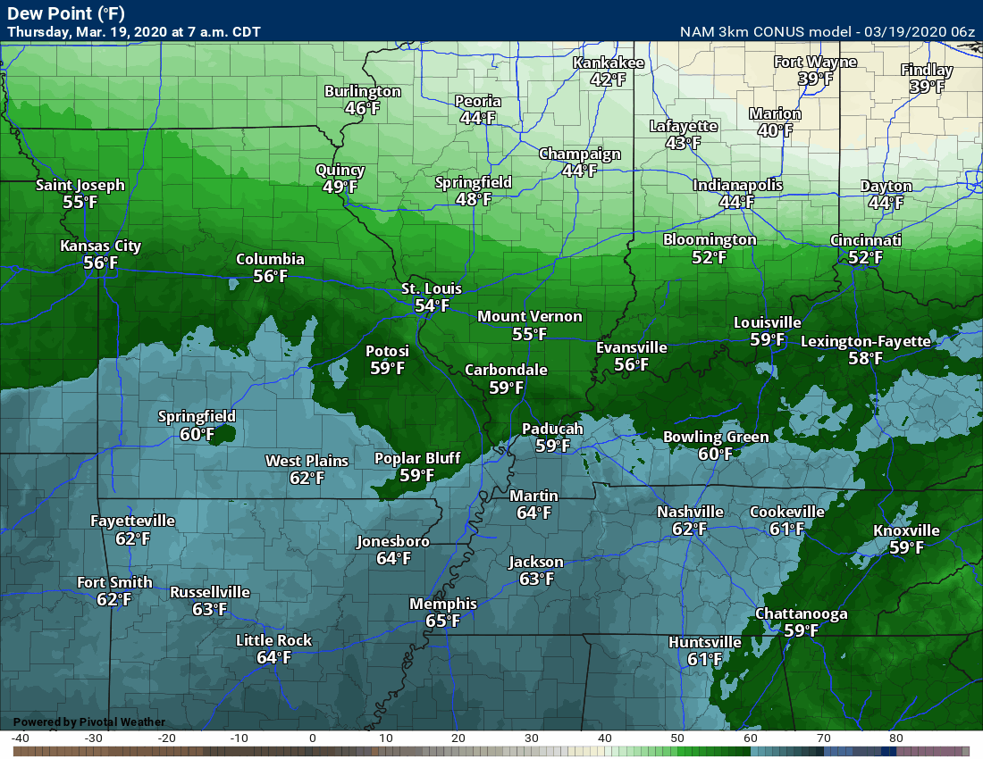
Now, let's look at the dew point animation. You can see a surge of moisture today through Thursday night.
That is plenty of moisture for locally heavy rain and even severe thunderstorms.
When forecasting severe weather, I look for dew points above 60 degrees. We definitely reach those levels. Half of the region, as of this typing, is already in the 60 to 65-degree range.
.
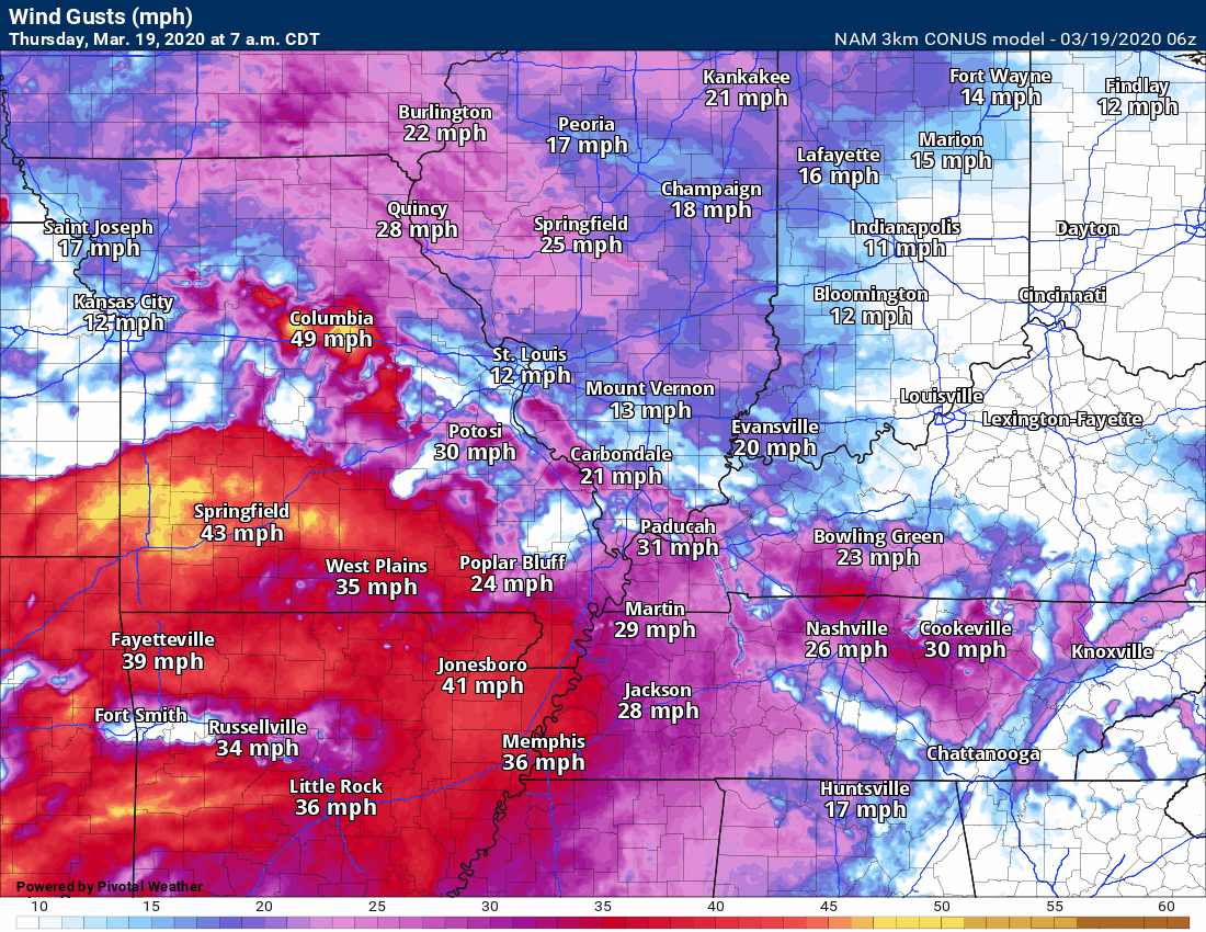
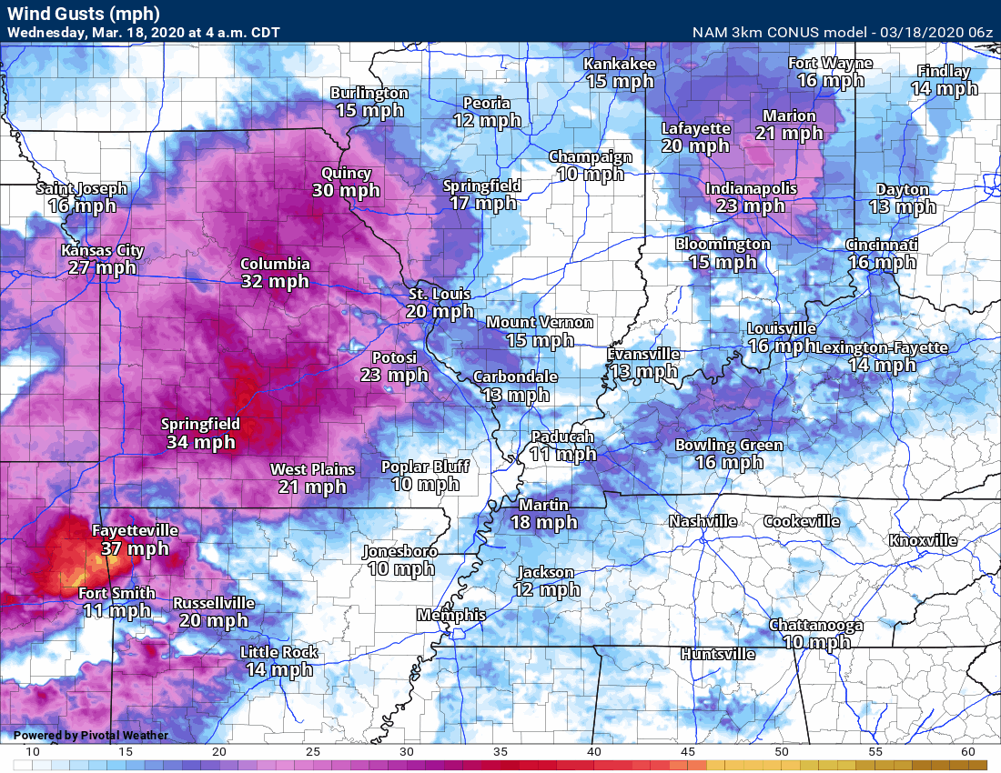
Strong and gusty winds will be with us through Friday.
The strongest wind gusts will occur on Thursday and Thursday night. That will occur because of a deepening area of low pressure pushing through the region.
.
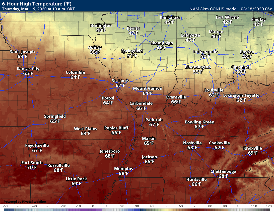
Let's take a look at the surge of warm air ahead of the cold front. Mild! Spring air. Full of moisture.
Then, at the end of this animation, you can see the cold front sweeping west to east. That drags colder air into the region.
That won't happen until Friday and Friday night. That is what leads to the upper 20s and lower 30s (see graphics further down).
.
Thursday, March 19, 2020
All modes of severe weather are possible this afternoon and tonight.
I will have a full update before 9 am.
No significant adjustments from previous forecasts. Monitor updates.
.
Wednesday, March 18, 2020
5:30 PM Update
From the NWS.
We're continuing to monitor the potential for severe weather Thursday into Thursday night.
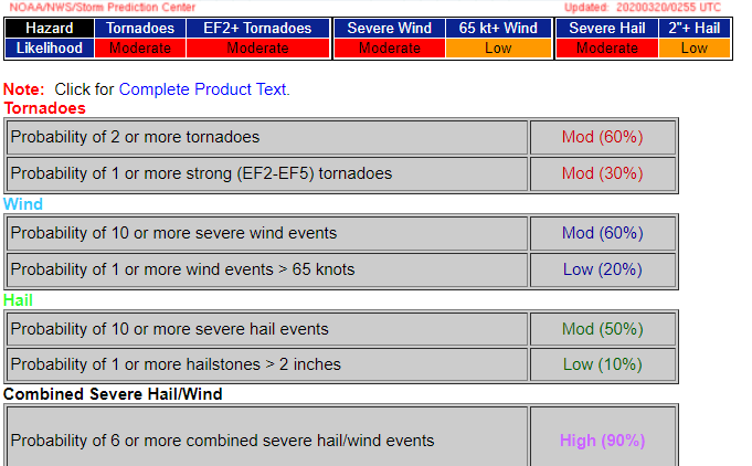
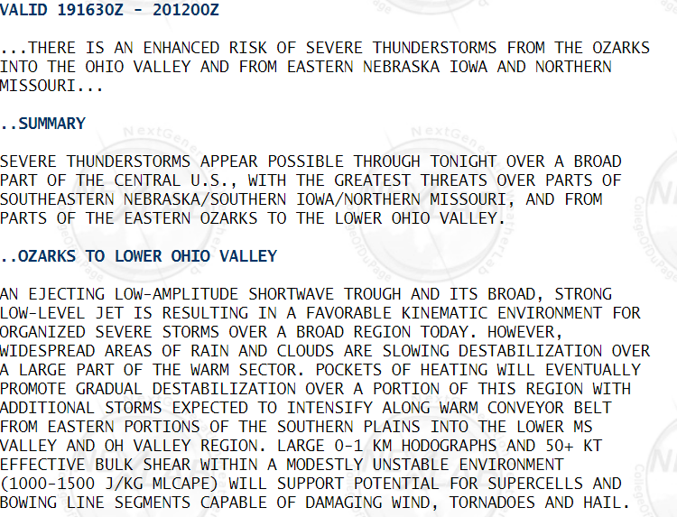
The Storm Prediction Center has outlooked most of the area in an ENHANCED (Level 3) risk for severe weather late Thursday afternoon into Thursday night.
One round of showers and scattered thunderstorms will lift northeast across the area late tonight and Thursday morning. The main impact with this initial round will be locally heavy rain and perhaps marginally severe hail.
After a break in the activity during the early to middle afternoon, the second round of thunderstorms is forecast to develop during the late afternoon and evening hours.
This activity will begin over southeast Missouri and southwest Illinois, then spread east across the rest of the area through the evening and possibly into the overnight hours.
All forms of severe weather will be possible, including large hail, damaging winds, and a few tornadoes. Significant tornadoes cannot be ruled out.
The storms may be more cellular in nature across southeast Missouri, with a transition to more linear convection as the activity shifts east. Even with the linear activity, embedded quick spin-up tornadoes will be possible.
Please stay in touch with the latest forecast and updates.
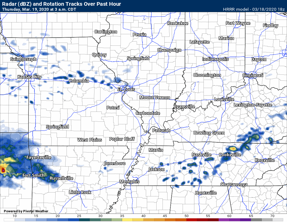
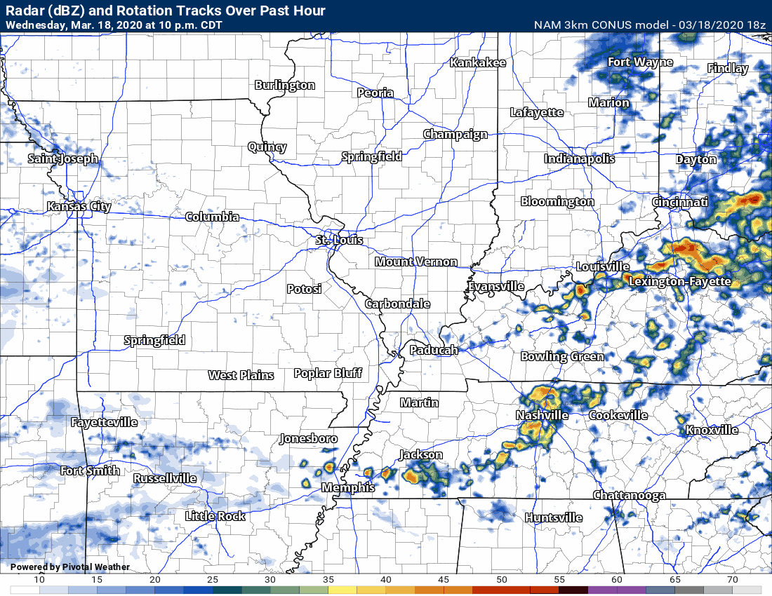
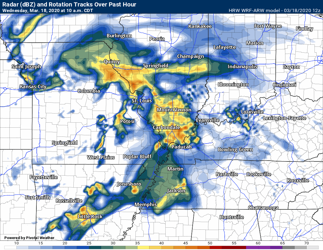
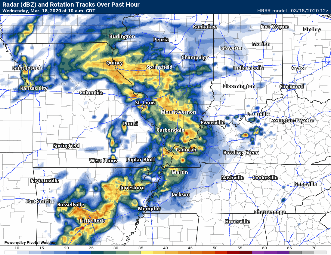
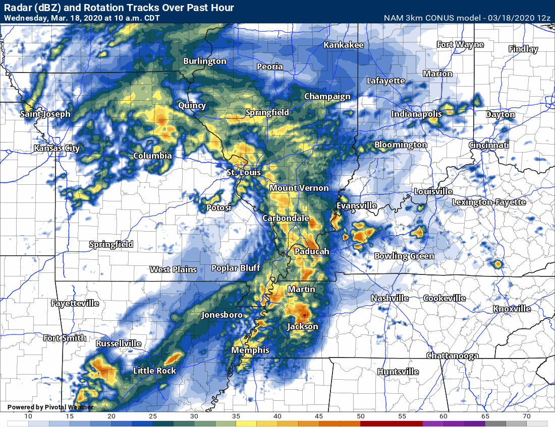
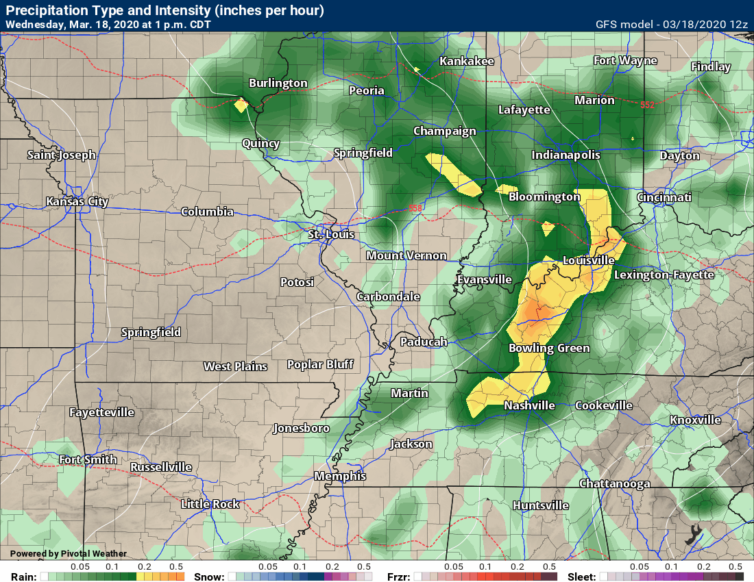
Here are two updated future-cast radars.
Hrrr model
NAM 3K model
.
Supercells are possible tomorrow afternoon and night.
A squall line is a line of storms. Supercells tend to be ahead of the squall line or spotty in nature.
Example of a squall line and supercell.
.
Squall line. Line of storms. Notice the top of the graphic. The storms ahead of the line? Storms like that are usually supercells.
Squall lines tend to product damaging wind and can have short-lived tornadoes embedded within them.
Supercells tend to produce longer tracked tornadoes. Larger hail. High wind gusts.
Both squall lines and supercells can produce damaging tornadoes.
.
Wednesday, March 18, 2020
12:45 PM Update
The Storm Prediction Center has expanded and increased its severe weather graphic.
We are now at a level three out of five risk. Five being the highest.
The SPC color scheme does have some downfalls. People tend to focus on the exact boundaries of the level system.
Don't pay too much attention to the exact lines and colors. Weather does not follow our colors.
Pay attention to the forecast. Severe weather is possible in our region on Thursday, Thursday night, and early Friday morning.
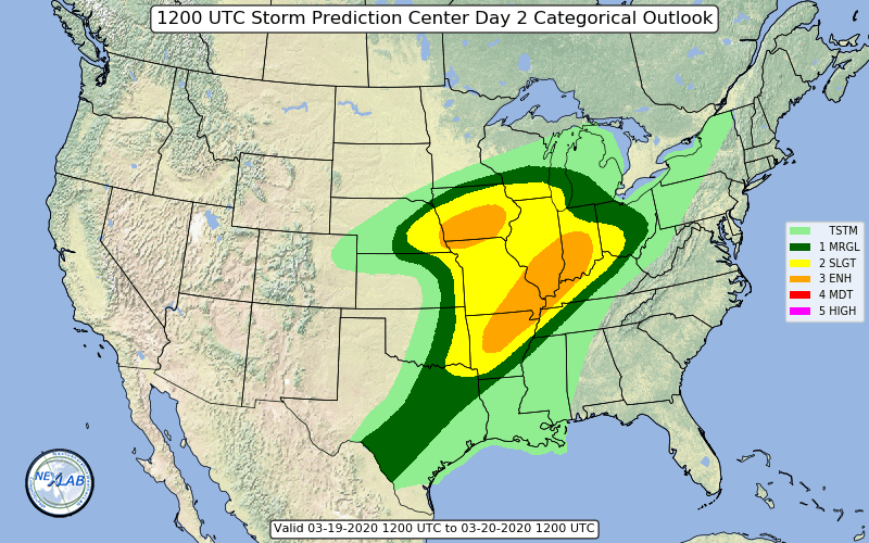
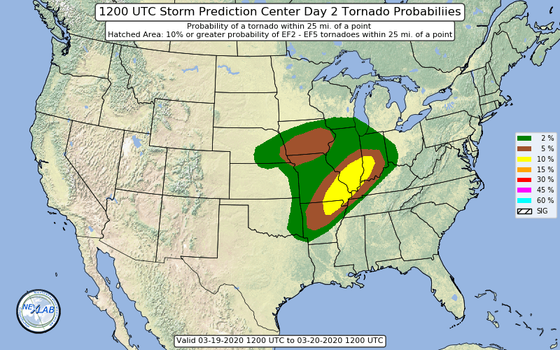
The tornado risk zone. The yellow zone has the greatest risk. This is for Thursday (mainly afternoon into Friday morning).
Wednesday, March 18, 2020
10:00 AM Update
Severe Weather Outlook.
Be prepared for watches and warnings.
A watch means to stay alert.
A warning means to take action and seek shelter. A warning is more serious than a watch.
Kids are out of school. Review your severe weather safety plan with them.
.
Wednesday afternoon and evening:
A few thunderstorms could produce nickel to quarter size hail this afternoon. Wind gusts to 55 mph will also be possible. The main concern will be over Kentucky and Tennessee. Instability will be lacking because of cloud cover and ongoing rain/storms. Confidence in severe weather today is low.
There is not a lot of CAPE to work with today. Think of CAPE as energy for thunderstorms to tap into.
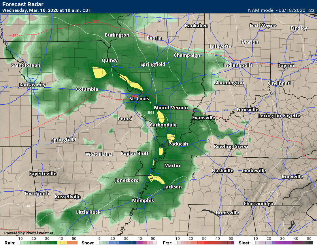
Here is the latest high-res WRF model. It does show a small line of showers and thunderstorms this afternoon (after this morning's rain event).
That is the line that could produce a few reports of severe weather.
.
Thursday morning:
A few of the thunderstorms on Thursday morning could produce large hail. A low-end wind risk, as well.
The region has been placed in a severe weather risk by the Storm Prediction Center.
The SPC color scheme does have some downfalls. People tend to focus on the exact boundaries of the level system.
Don't pay too much attention to the exact lines and colors. Weather does not follow our colors.
Pay attention to the forecast. There is a low-end risk of severe weather over portions of the region later today. Mainly, in the dark green zone.
The official Storm Prediction Center outlook (which will be updated several times today) shows a level one chance of severe thunderstorms. That would be the dark green zone.
Orange is the level 3 zone. Yellow is a level 2 zone. Dark green is a level 1 zone. Three is the highest. One is the lowest. The light green is where sub-severe storms are possible.

.
Thursday afternoon into early Friday morning:
A higher-end severe weather event is taking shape for Thursday afternoon into early Friday morning.
Confidence is medium.
All modes of severe weather will be possible. That includes tornadoes.
This event could last the entire night. In other words, we may have watches and warnings well after midnight.
This raises concerns. Most of our region's tornado deaths occur at night. Have multiple ways of receiving your severe weather warnings. That includes the Beau Dodson Weather Talk app and a NOAA Weather Radio.
Here is more detailed information concerning the event.
The SPC color scheme does have some downfalls. People tend to focus on the exact boundaries of the level system.
A tornado is a tornado. If it occurs in the dark green or yellow (other colors) zone. It does not matter. We use the SPC color scheme for guidance.
Again, don't pay too much attention to the exact lines and colors. Weather does not follow our colors.
Pay attention to the forecast. There is a risk of severe weather on Thursday and Thursday night. The risk will continue past midnight into Friday morning.
Dark green is a level 1 zone. One is the lowest. Then, the scale moves higher from there. The light green is where sub-severe storms are possible.
Again, don't get caught up in the colors. Just pay attention to my forecast. Some storms could be severe on Thursday into early Friday morning.
This graphic WILL change. The SPC will update multiple times between now and the event.
I do expect them to expand the risk zone and perhaps raise it.

.
Severe Thunderstorms Thursday and Thursday night/Friday morning
The ingredients are coming together for severe weather thunderstorms.
Thursday AM
There is a chance of hail during the morning hours (Thursday). Then, a lull in the precipitation.
This is the 7 AM future-cast radar. Those storms in our region could produce pea to quarter size hail as the rapidly move northeast.
.
Thursday afternoon into Friday morning
Additional thunderstorms form in the warm and moist air-mass by Thursday afternoon and night. There will be plenty of wind shear. Wind shear is one ingredient for severe weather.
Wind shear has two components. Speed shear and directional shear. Speed shear is when winds increase with height. Directional shear is when the wind turns with height. Those two ingredients help thunderstorms vent and become severe.
There will be no lack of wind shear with this system. High wind shear numbers are a concern. That is especially true on Thursday night.
If supercells do develop then they will become severe with hail, damaging wind, and tornadoes. Make sure you are using the Weather Talk app.
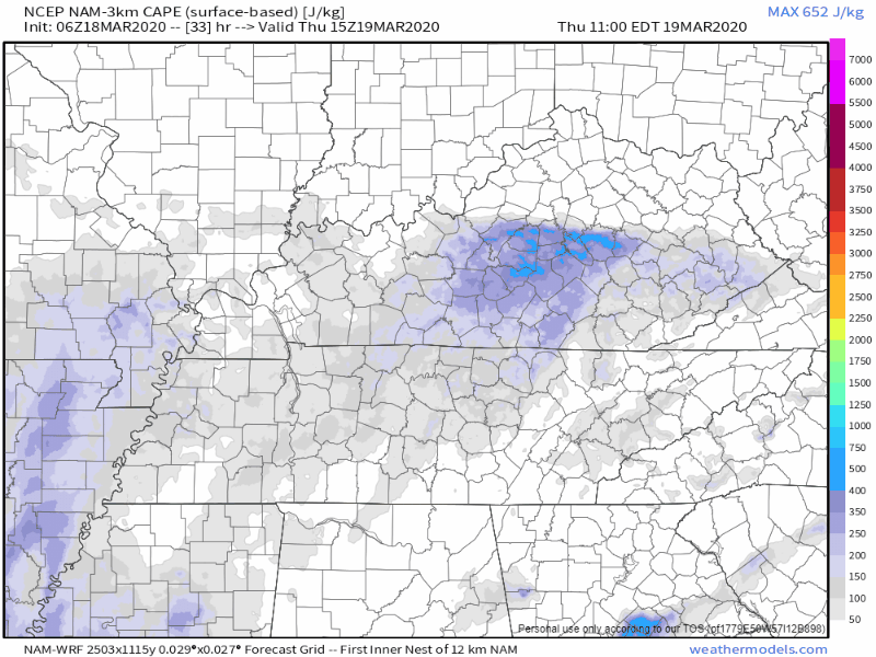
Here is the CAPE animation. CAPE is basically energy for thunderstorms to tap into.
Notice how this threat extends well into the overnight hours (even past midnight). The animation is in Zulu time. 00z = 7 pm. 06z = 1 am. 12z = 7 am. 18z = 1 pm.
The NAM model shows enough CAPE for severe weather concerns.
Let me stop the animation and show you a few frames.
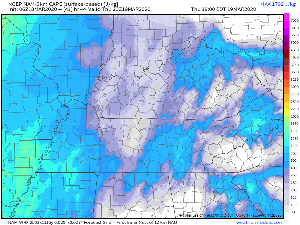
This image is the CAPE forecast for Thursday evening. Widespread CAPE across the region.
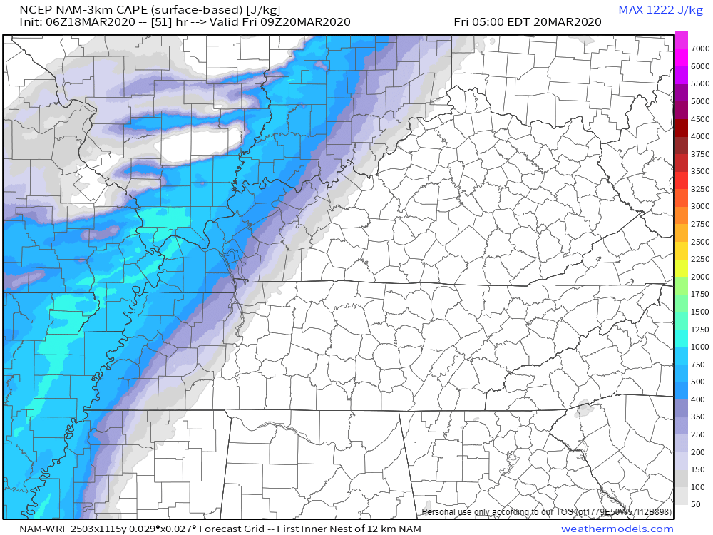
Here is the 3 am to 5 am Friday morning CAPE numbers. They spike ahead of the cold front. It is possible that we have severe weather warnings well after midnight Thursday night/Friday morning.
Here is the STP forecast for Thursday evening. The STP forecast is a tornado ingredient graphic. You can see that we have decent numbers across most of the area.
What does that mean? It means there will be wind shear. There will be a spin in the atmosphere. If thunderstorms develop then they could become severe.
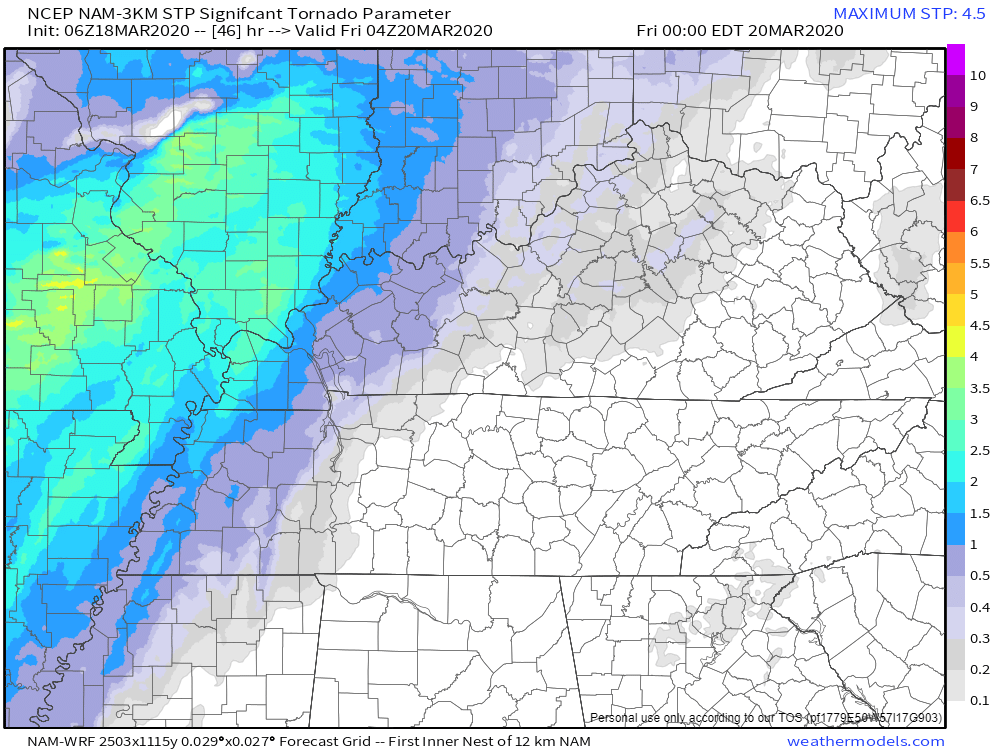
3 AM to 5 AM Friday morning STP numbers. You can see that spin right along the leading edge of the incoming cold front that will move west to east. Those colors will be shifting west to east Thursday night and Friday morning. This simply means that we need to monitor updates with this weather event. Some severe weather will be possible. The highest chance will be Thursday afternoon into early Friday morning.
Let's look at the supercell composite parameter graphic. Supercells are typically lone thunderstorms that are away from a line of thunderstorms. In other words, supercells tend to be more isolated than other storms.
Often times, we have a solid line of thunderstorms along a cold front. Then, you can have thunderstorms ahead of the line. We call those supercells. Supercells can produce higher-end large hail, very high wind gusts, and tornadoes.
There are cases where supercells are embedded in lines, as well.
This is likely to be a mixed-mode event. There should be some supercell activity and a line of thunderstorms. Both. Both can produce severe weather.
I wanted to show you this graphic because it shows you that we do have the ingredients for severe weather Thursday afternoon and night. You can see how those colors end behind the cold front as it moves west to east.
.
This next graphic is from the SREF model.
These are high numbers for Thursday night and Friday morning (very early Friday morning - before sunrise).
This raises concerns. If this does verify then we would have a tornado threat into the wee morning hours of Friday. That would be while most people are sleeping.
Let's keep a close eye on this.
This is the tornado ingredient graphic. What does it mean? It simply tells me that there is a chance of tornadoes. The bullseye is over our region.
Keep in mind, as always, these are models. Models are not perfect. They are used for guidance. This is one of many graphics that I monitor and input into my forecast.
.
This is the tornado ingredient animation. This takes us through Thursday and Thursday night. The concerns peak on Thursday afternoon and night.
.
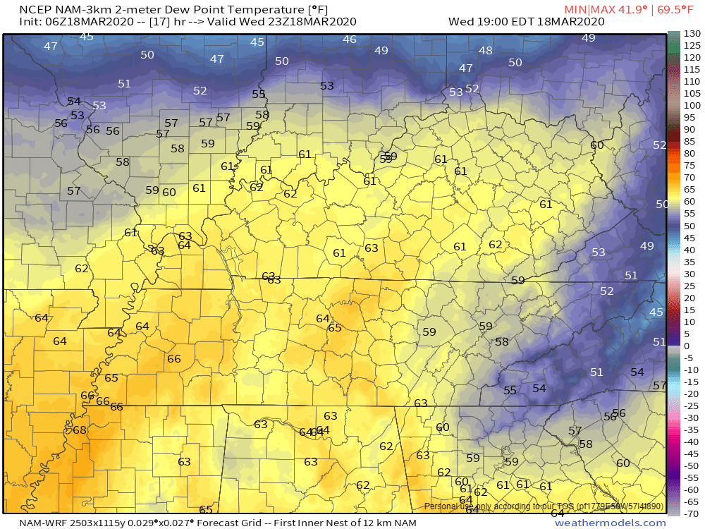
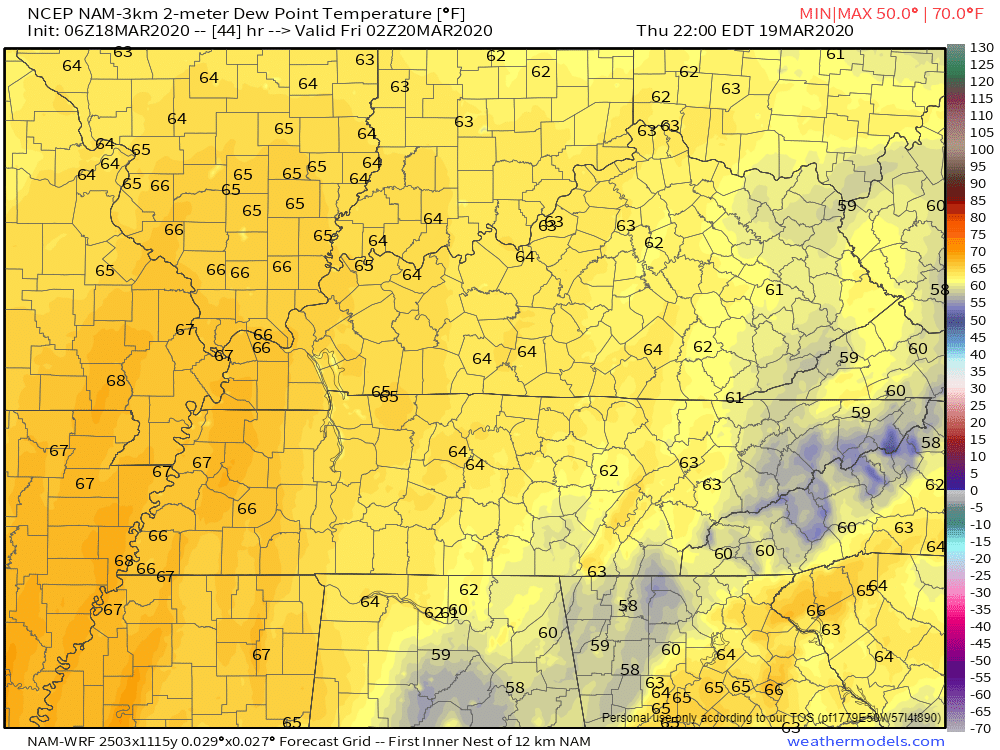
Dew point is a measure of moisture in the atmosphere. When it comes to severe weather forecasting, I look for readings of 60 and above.
We do meet and exceed that number over the region today and especially on Thursday and Thursday night. That is plenty of fuel for severe thunderstorms.
If we have CAPE/instability then severe weather will occur. The greatest concern will be Thursday afternoon and night.
This afternoon's dew point readings
Thursday night's dew points. A surge of higher readings.
.
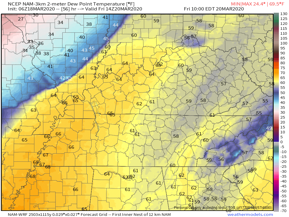
Thursday night's dew point readings. This is around 5 AM. It is possible that we have severe weather concerns well into Thursday night/early Friday morning.
Look at the sharp drop-off of dew point readings behind the cold front. It is like a Texas dry-line.
.
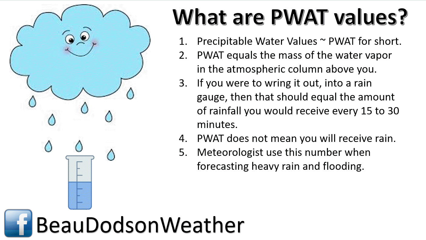
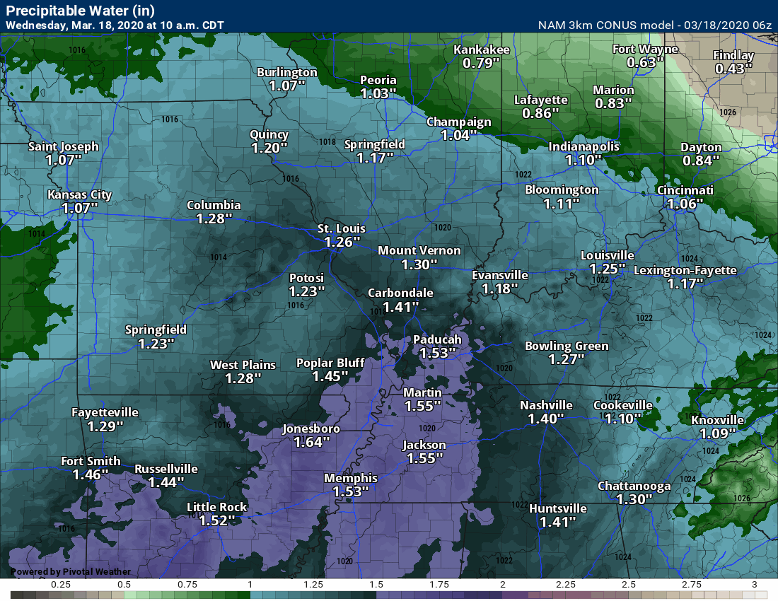
Precipitation water values. What are they?
.
Now, let's look at the PWAT animation. You can see a surge of moisture today through Thursday night.
That is plenty of moisture for locally heavy rain.
.
Strong and gusty winds will be with us through Friday.
The strongest wind gusts will occur on Thursday and Thursday night. That will occur because of a deepening area of low pressure pushing through the region.
.
Let's take a look at the surge of warm air ahead of the cold front. Mild! Spring air. Full of moisture.
Then, at the end of this animation, you can see the cold front sweeping west to east. That drags colder air into the region.
That won't happen until Friday and Friday night. That is what leads to the upper 20s and lower 30s (see graphics further down).
.
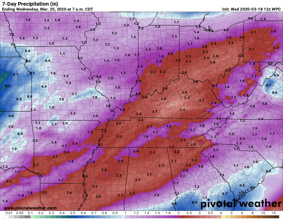
.Rain totals through Sunday night will likely range from 1.0" to 2.5" with local amounts exceeding three inches.
Thunderstorms can always produce locally higher totals.
.
 .
.
Click here if you would like to return to the top of the page.
Again, as a reminder, these are models. They are never 100% accurate. Take the general idea from them.
What should I take from these?
- The general idea and not specifics. Models usually do well with the generalities.
- The time-stamp is located in the upper left corner.
.
What am I looking at?
You are looking at different models. Meteorologists use many different models to forecast the weather. All models are wrong. Some are more wrong than others. Meteorologists have to make a forecast based on the guidance/models.
I show you these so you can see what the different models are showing as far as precipitation. If most of the models agree, then the confidence in the final weather forecast increases.
This is the high-resolution SPC WRF model guidance.
Blue is snow. Purple is sleet. Green is rain.
Time-stamp upper left. Click the animation to enlarge it.
This is the high-resolution Hrrr model guidance.
Blue is snow. Purple is sleet. Green is rain.
Time-stamp upper left. Click the animation to enlarge it.
This is the high-resolution NAM 3K model guidance.
Blue is snow. Purple is sleet. Green is rain.
Time-stamp upper left. Click the animation to enlarge it.
.
This next animation is the NAM American Model.
This animation shows you what radar might look like as the system pulls through the region. It is a future-cast radar.
Green is rain. Blue is snow. Pink and red represent sleet and freezing rain.
Time-stamp upper left. Click the animation to enlarge it.
.
This next animation is the GFS American Model.
This animation shows you what radar might look like as the system pulls through the region. It is a future-cast radar.
Green is rain. Blue is snow. Pink and red represent sleet and freezing rain.
Time-stamp upper left. Click the animation to enlarge it.
.
DOWNLOAD the Beau Dodson Weather app (see links below). Make sure you have turned on Weather One in your www.weathertalk.com account. That can be found under the personal notification settings tab.
APP LINKS (for subscribers). Not a subscriber? Go to www.weathertalk.com/welcome
Apple users: Beau Dodson Weather App
https://wtalk.co/QT95AQ7H
Android users: Beau Dodson Weather App
https://wtalk.co/D5USLZ3Q
.
Radars
Interactive city-view radars
http://weatherobservatory.com/weather-radar.htm
A third backup radar
https://weathertalk.com/morani
Clickable watches and warnings can be viewed on the local city-view interactive radars (link above). Be sure and turn on the warnings above the local radars.
A new regional radar we offer
https://imagery.weathertalk.com/prx/RadarLoop.mp4
Lightning data
https://wtalk.co/7QT7WHKU
Not receiving app/text messages?
USE THE APP. ATT and Verizon are slowing or stopping the text messages.
Make sure you have the correct app/text options turned on. Find those under the personal notification settings tab at www.weathertalk.com. Red is off. Green is on.
Subscribers, PLEASE USE THE APP. ATT and Verizon are not reliable during severe weather. They are delaying text messages.
The app is under WeatherTalk in the app store.

Apple users click here

Android users click here
.

Live lightning data: Click here.
National map of weather watches and warnings. Click here.
Storm Prediction Center. Click here.
Weather Prediction Center. Click here.

Interactive GOES R satellite. Track clouds. Click here.
GOES 16 slider tool. Click here.
College of Dupage satellites. Click here
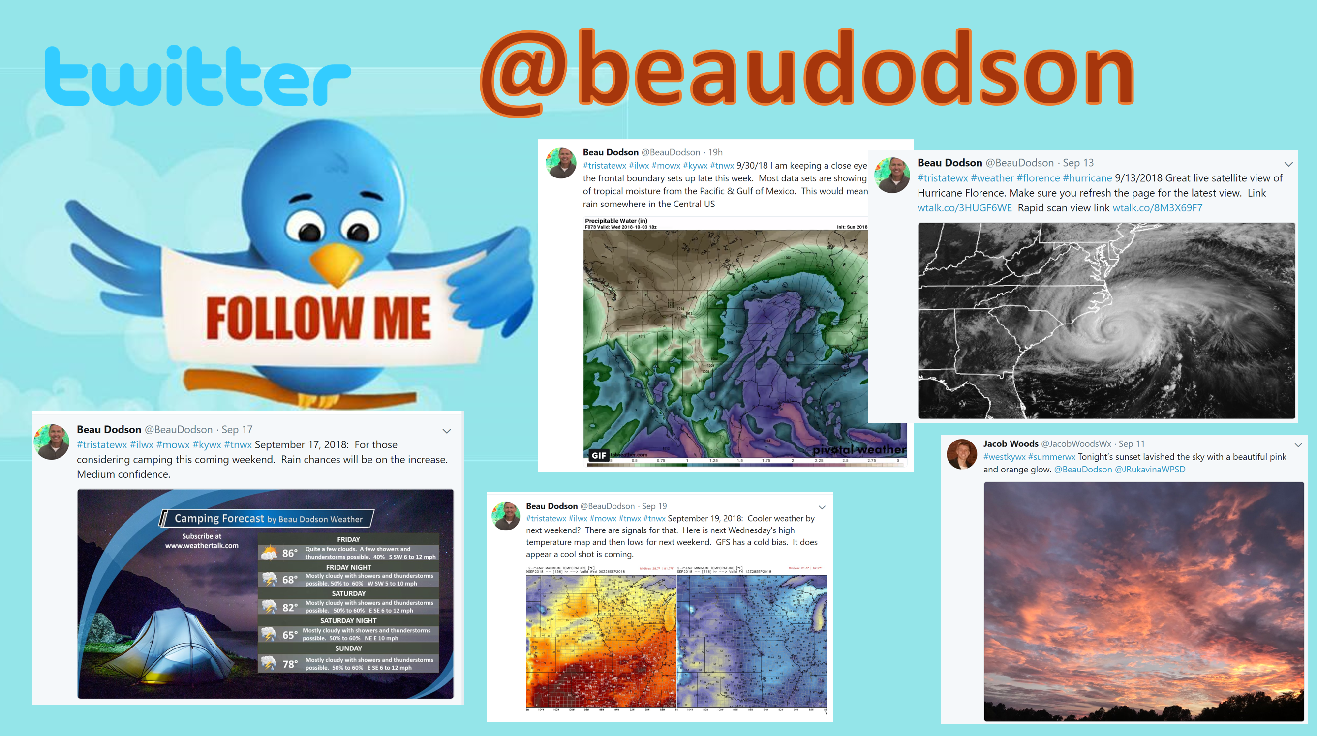
Did you know that you can find me on Twitter? Click here to view my Twitter weather account.
.![]()
Find Beau on Facebook! Click the banner.

.
Find Beau on Twitter! Share your weather photos! @beaudodson

.
![]()
![]()
Did you know that a portion of your monthly subscription helps support local charity projects? Not a subscriber? Becoming one at www.weathertalk.com
You can learn more about those projects by visiting the Shadow Angel Foundation website and the Beau Dodson News website.