Weather Blog Post
Last Updated: Jul 17, 2019 11:04 PM
July 14th through the 17th
BEGIN LIVE BLOG
.

Live lightning data: Click here.

Radar Link: Interactive local city-view radars & regional radars.
.
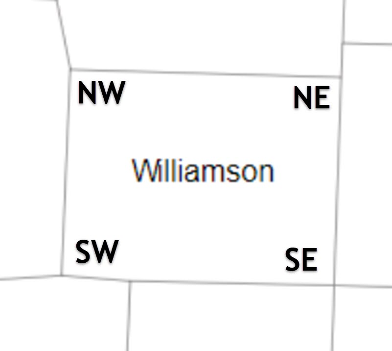
County Maps: Click Here
Also, someone asked about county directions.
Click the image to enlarge it.
.
.
FACEBOOK Q&A LINK
CLICK HERE
.
.
Live-interactive radars: Click here
Regional radar link: Click here
.
Live lightning data: Click here.
.
Additional storm tracking tools can be found at the bottom of the page.
.
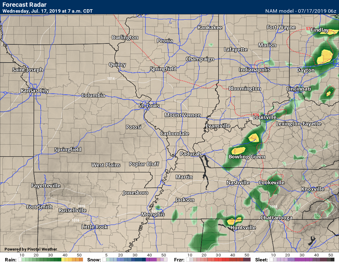
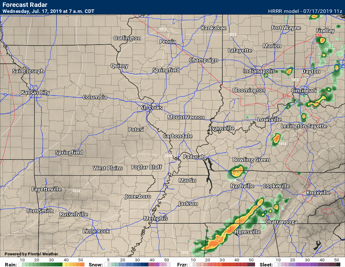
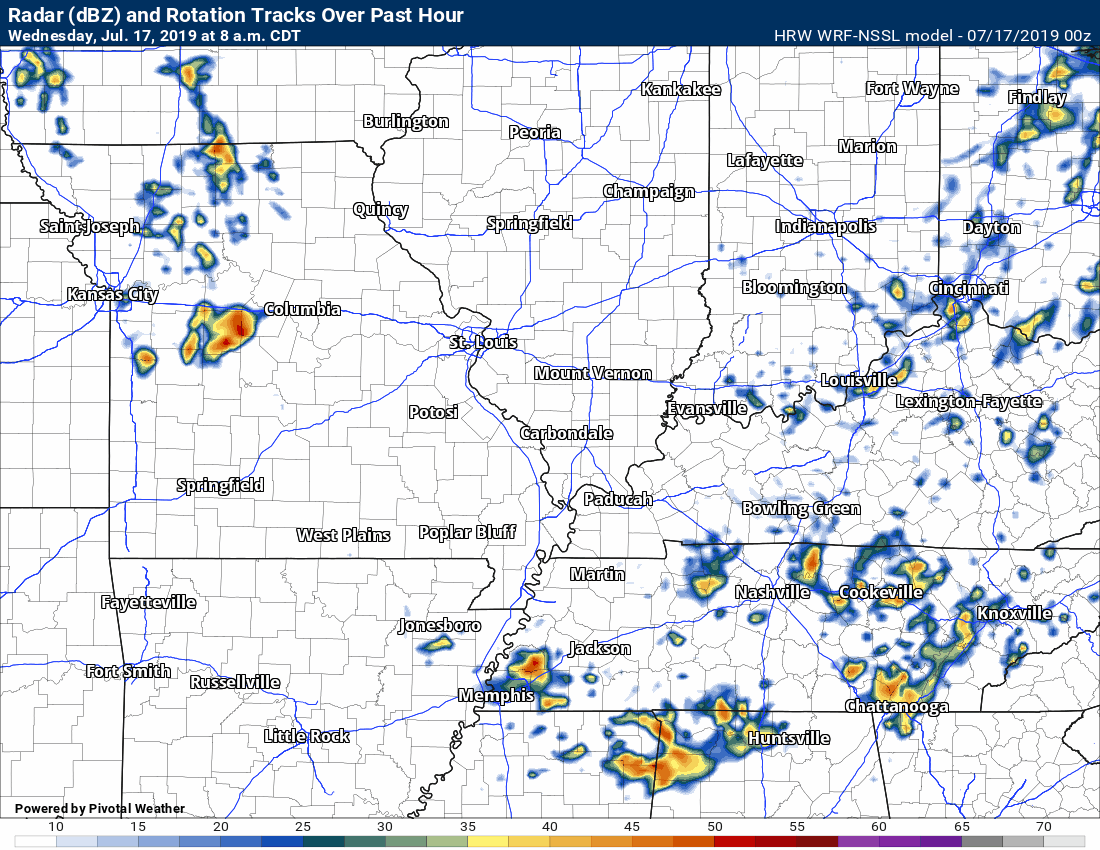
Wednesday, July 17, 2019
.
11 PM
Severe weather risk has ended.
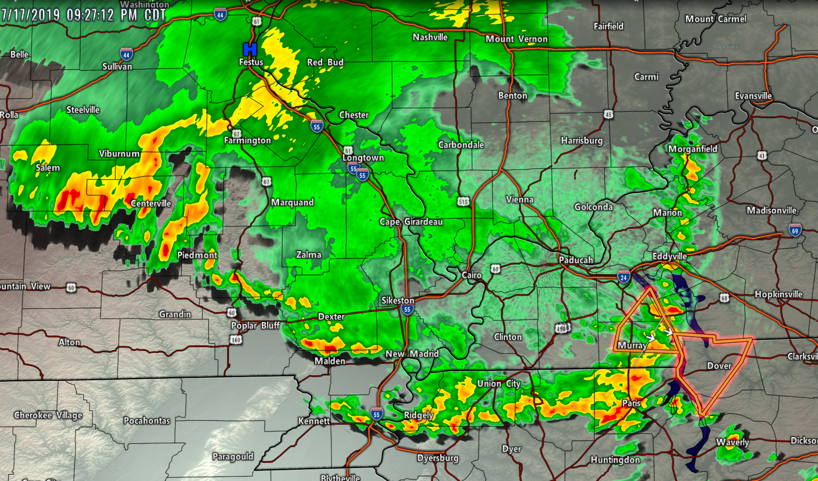
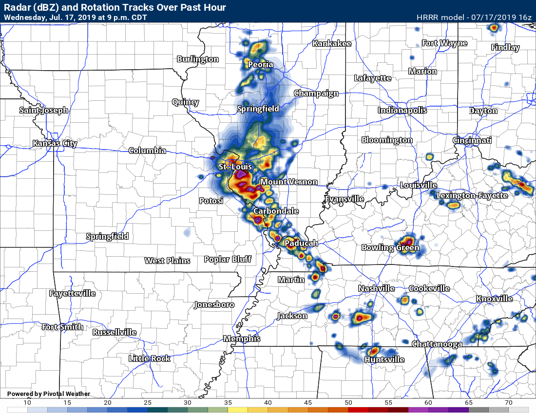
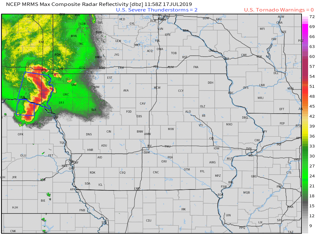
9:53 PM
Butler, southern Stoddard, Dunklin, western New Madrid, and Pemiscot. Heavy rain is training over your counties. Rain totals in excess of two inches will occur in some locations.
Flash flooding is a concern.
.
9:30 PM
Quite a few reports of wind damage tonight. I have not posted all of the reports.
Here is one
Local Storm Report by NWS PAH: 3 NNE Boaz [Graves Co, KY] emergency manager reports TSTM WND DMG at 08:28 PM CDT -- tree down and large limbs down near old Mayfield road and Hopewell road.
.
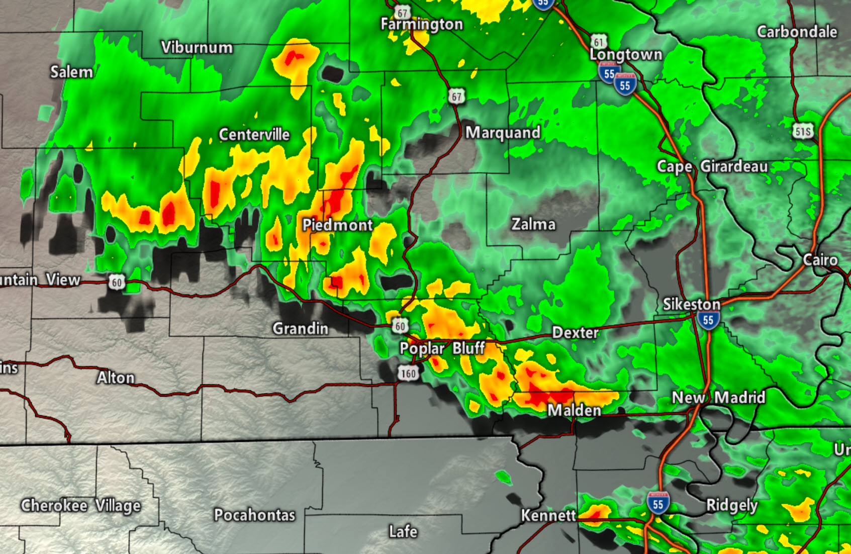
9:27 PM
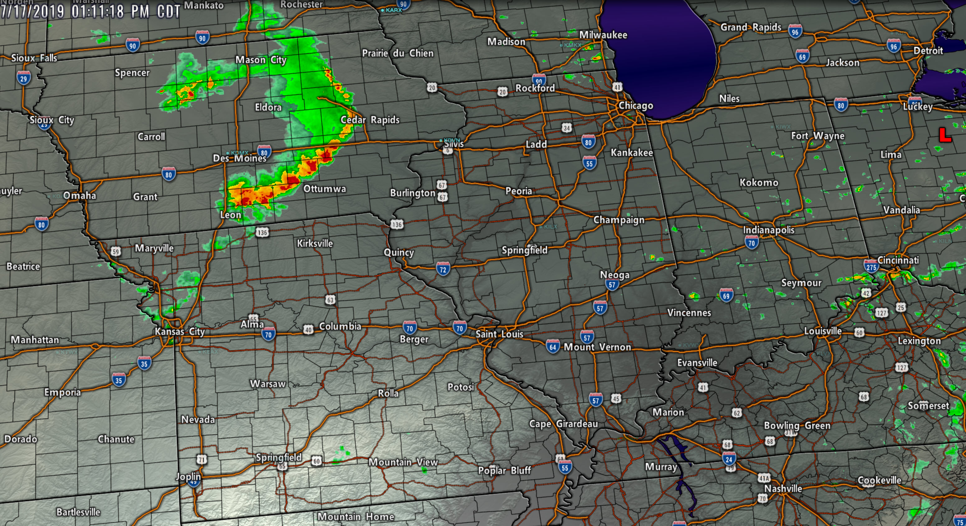
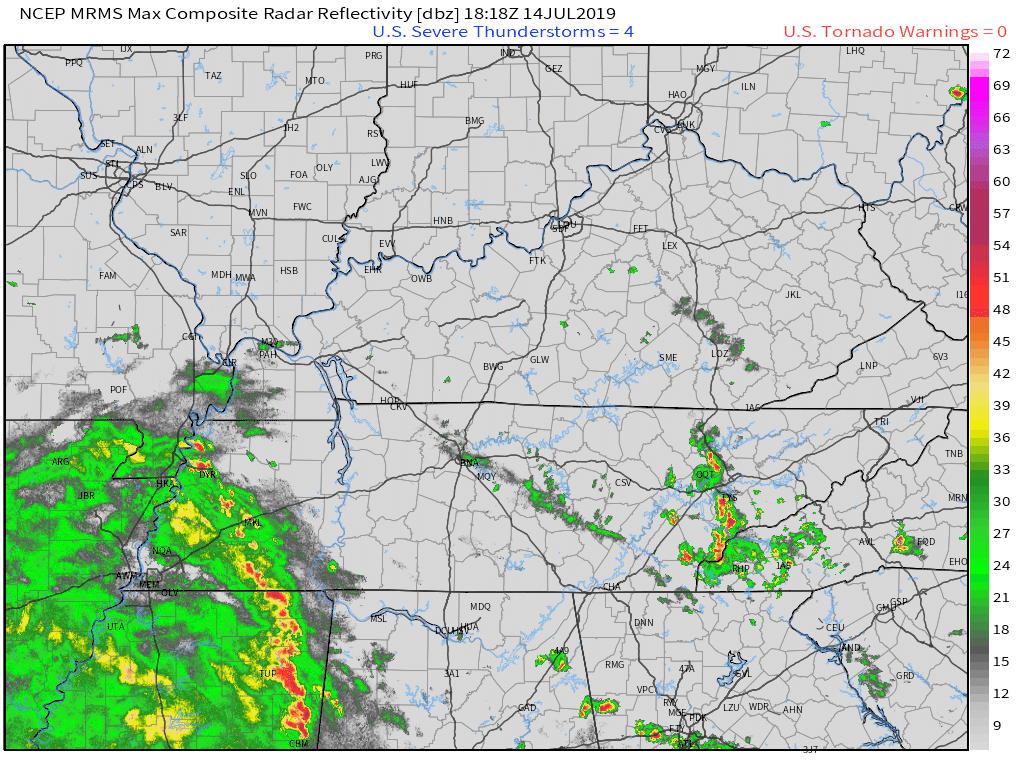
A few strong storms remain. There has been a weakening, overall.
Storms are moving south and southeast at 20 mph. Heavy rain under them. Sporadic strong winds.
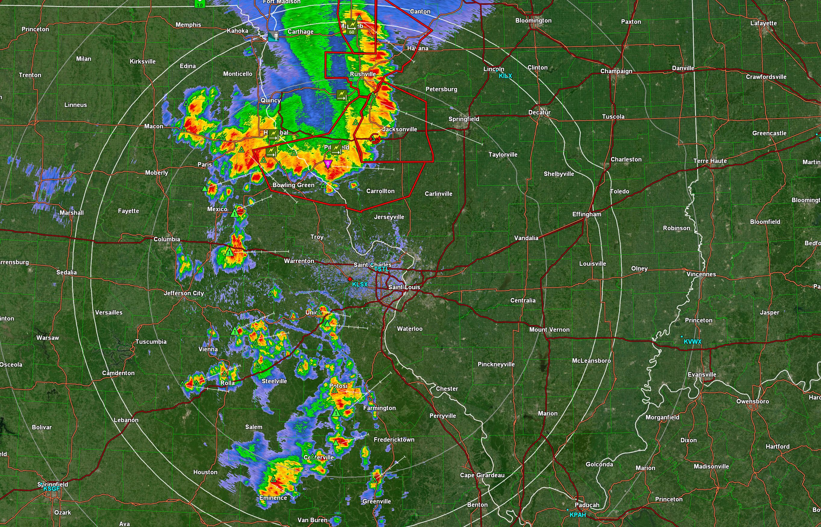
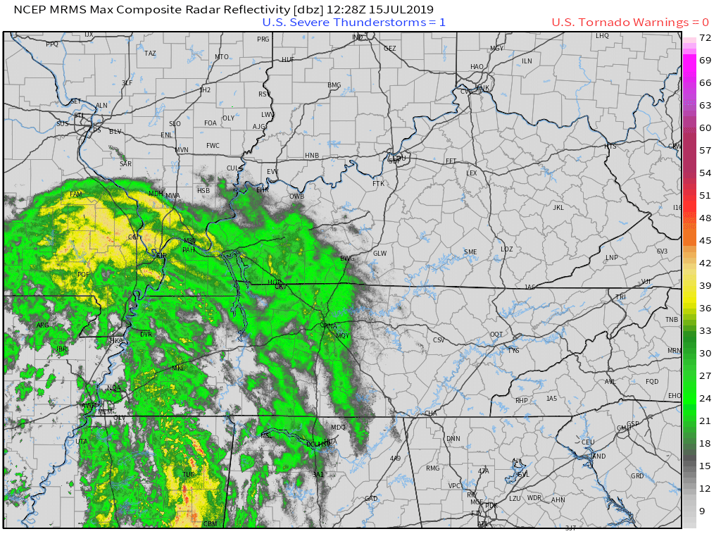
Click to enlarge
.
9:24 PM
Storms in southern MO are moving S and a little SE. Could train into Butler County with heavy rain later.
Otherwise, here is the live radar page
http://weatherobservatory.com/weather-radar.htm
.
9:07 PM
No major concerns the rest of tonight. Once these main storms push south and east. That will bring an end to severe concerns.
There are some storms in southern Missouri. Those are currently west of my forecast zone.
Live-interactive radars: Click here
Regional radar link: Click here
.
8:44 PM
Union, Crittenden, Lyon, Trigg. Storms are moving east towards your county. They are weakening but if they hold together a few storms could produce isolated high winds. We are losing the heating of the day. They should weaken with time.
.
8:40 PM
Impressive how the storms held together.
Radar loop
8:39 PM
Calloway. Storms approaching from the NW. They have a history of sporadic wind damage. Be aware as they push into your county shortly.
.
8:33 PM
Saline, northern Pope, Gallatin, Hardin. Storms have increased in intensity just a bit. I can't rule out isolated wind damage reports. Moving SE at 20 mph.
.
8:31 PM
Livingston. The heaviest of the storms may stay just south of your county or clip the extreme south portion
.
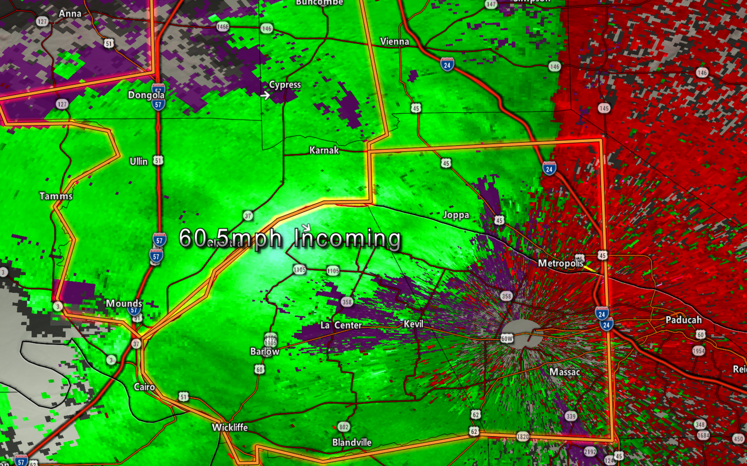
8:27 PM
Marshall and southern Livingston. Incoming storms from the west could produce sporadic wind damage. Winds of 55 mph were reported in Metropolis, IL.
.
8:22 PM
White County. Storms moving in from the west have a history of sporadic wind damage. Just be alert as they move through.
.
8:21 PM
Lake, Obion, Weakley, and Henry. Storms mainly to your north/northwest are moving southward. Sporadic wind damage is possible. Very heavy rain under the storm cells.
.
8:15 PM
Quite a bit of wind damage reported in Mt Vernon, IL. Trees down, large limbs, power lines down.
.
8:14 PM
Massac and McCracken update. Highest winds on radar are in southern McCracken County. Elsewhere, there are isolated high winds on radar. Stay aware as storms move E SE at 20 mph.
.
8:10 Pm
Hamilton and Wayne. We have storms moving in from the west. There have been reports of tree damage in Jefferson County. Sporadic damaging wind is possible with the storms. Movement is E SE at 20 mph.
.
8:08 PM
Mccracken and north Graves. Radar shows a downburst (damaging wind) NE of Lovelaceville in extreme SW McCracken County. Moving E SE at 20. Just be aware of this.
.
8:05 PM
Graves County. General heads up. Incoming storms could produce isolated wind damage. Torrential rain under the cells, as well. Moving E SE at 20 mph.
.
8:00 PM
Radar shows a very small area of 50+ winds now NW of Bandana, KY. Winds elsewhere are much lower. A very small area now.
.
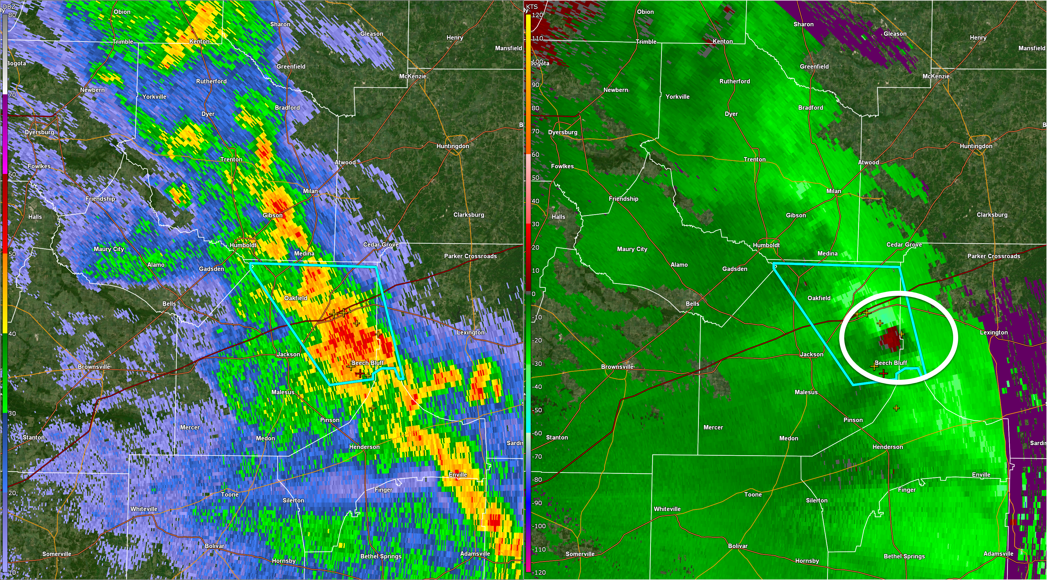
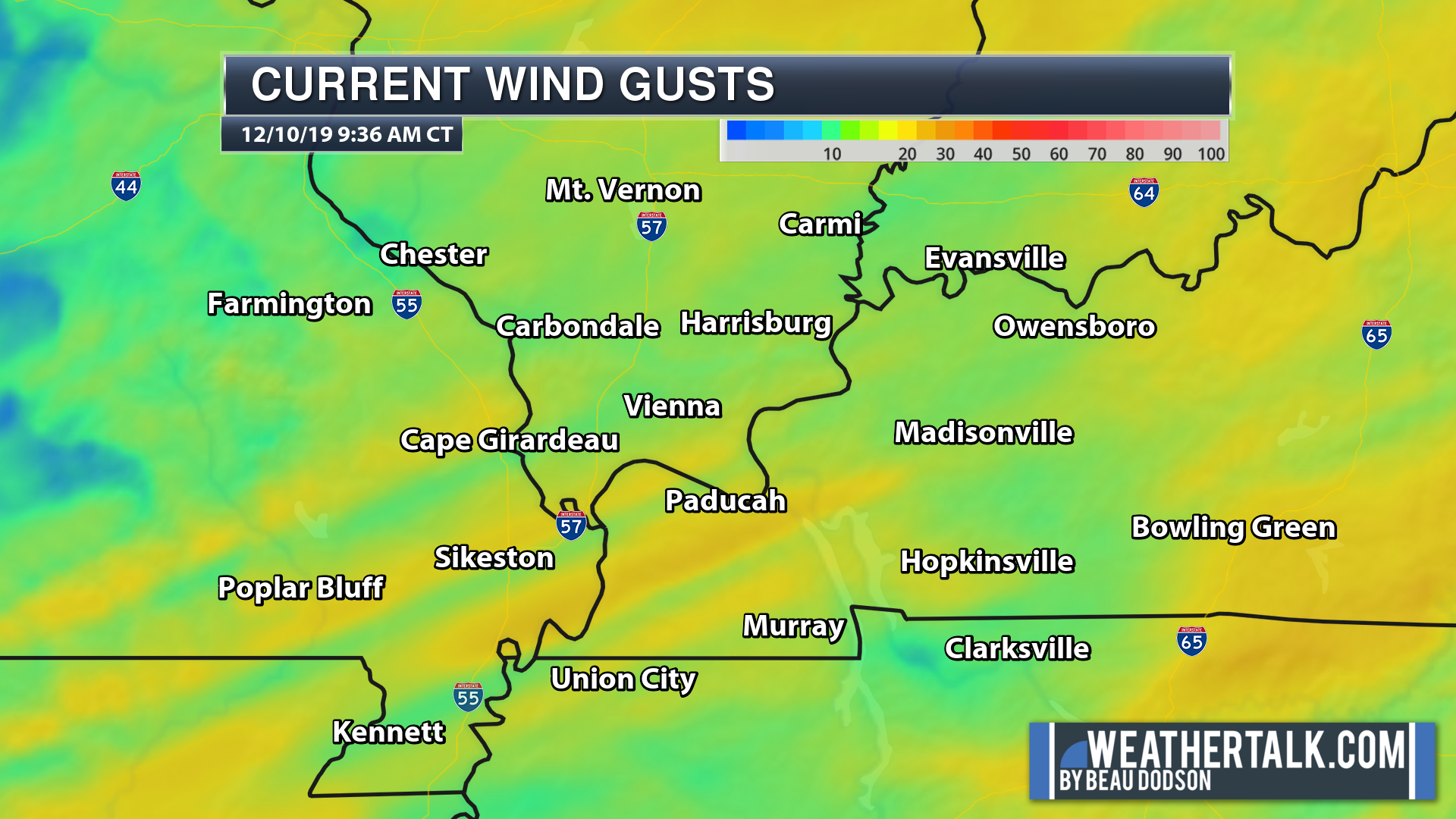
7:52 PM
Highest wind sig is over northern Ballard County, at this time. 7:52 PM
Click to enlarge.
These colors represent wind. The light blue represents 50 to 60 mph gusts.
.
7:48 PM
Radar shows 55 to 60 mph winds approaching extreme SW Massac County and northern McCracken County. Moving SE 20 mph.
.
7:45 PM
Radar shows high winds entering extreme northern Ballard County.
You can see it here. I circled it. Moving southeast at 20 mph.
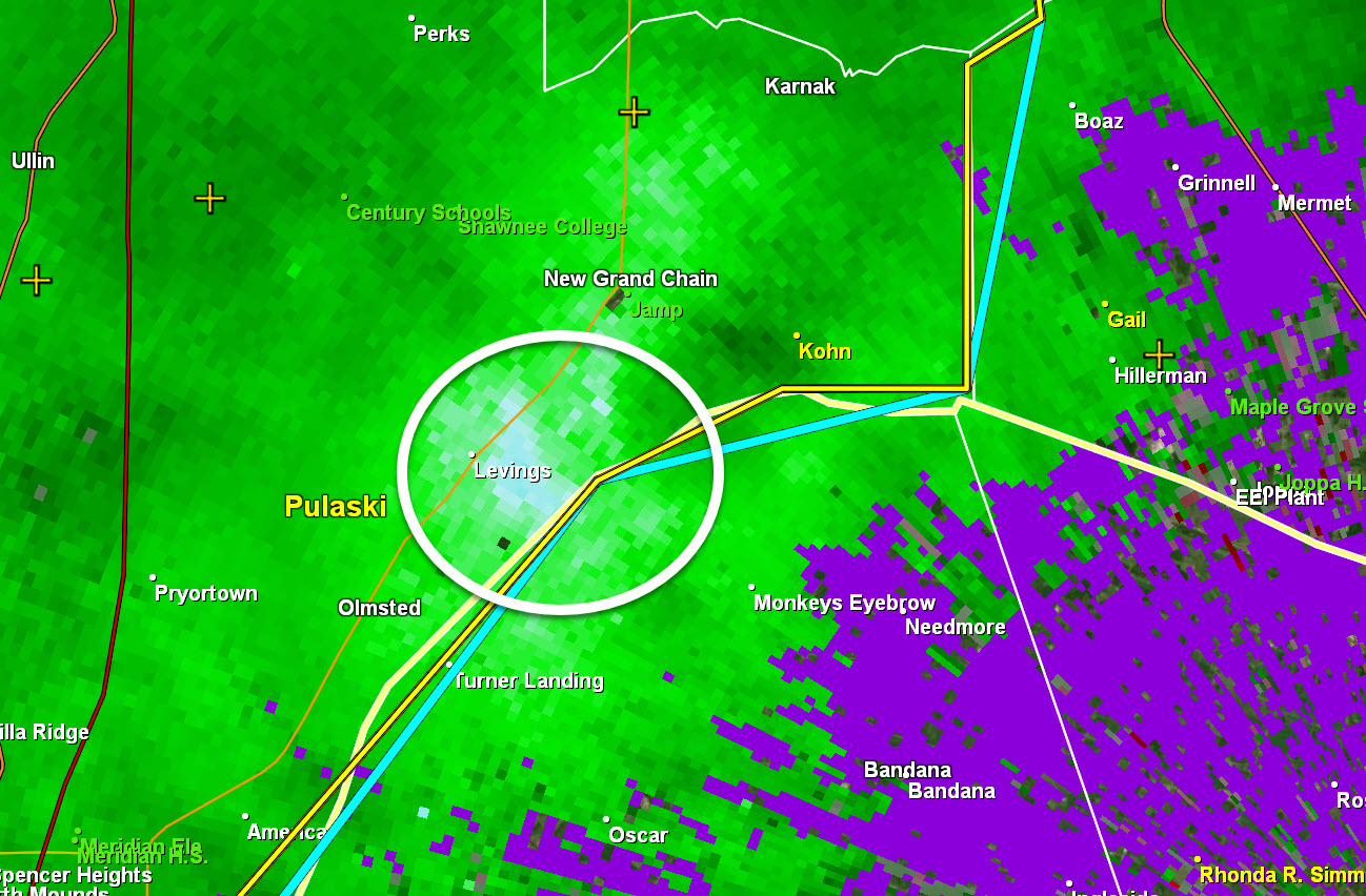
.
7:40 PM
Dunklin, Pemiscot, New Madrid Counties, MO. Carlisle, Hickman, & Fulton Counties. General heads up that incoming storms could produce isolated 50+ mph wind gusts. Heavy rain/lightning. Be aware.
Radar Link: Interactive local city-view radars & regional radars.
.
7:25 PM
Massac and McCracken. Storms approaching from W NW moving E SE at 20. There have been reports of isolated wind damage. Slow movers. Heavy rain. Be aware.
Jefferson and Franklin. Intense storms approaching from the NW. Slow movement SE at 15 to 20 mph. Sporadic patches of 50+ winds are likely with the storms. Heavy rain.
.
7:22 PM
Storms entering Williamson County are not all that impressive.
Lightning is your main concern and gusty winds along the gust front.
7:20 PM Johnson and Pulaski Counties. Ballard and Mississippi Counties. Radar shows incoming storms with isolated patches of 50+ mph winds. Wet ground conditions could make it easier for a tree to topple. Be aware as they move east at 15 to 20 mph.
.
7:03 PM
Union County, IL. Alexander County, IL. Scott County, MO. Storms continue to move E SE. Radar shows some small patches of 50+ mph winds sporadically mixed in with the storms. Wet ground conditions could mean that it is a bit easier to topple a tree. Be aware.
.
6:57 PM
.
6:50 PM
Storms to continue to slowly track east into southwest Illinois. One report of a tree snapped in Cape Girardeau County.
Many of the storms likely have strong and gusty winds. Wet soil conditions will make it easier for a tree to be uprooted.
Widespread damaging wind has not been reported. So, that is good.
Live lightning data Click here
.
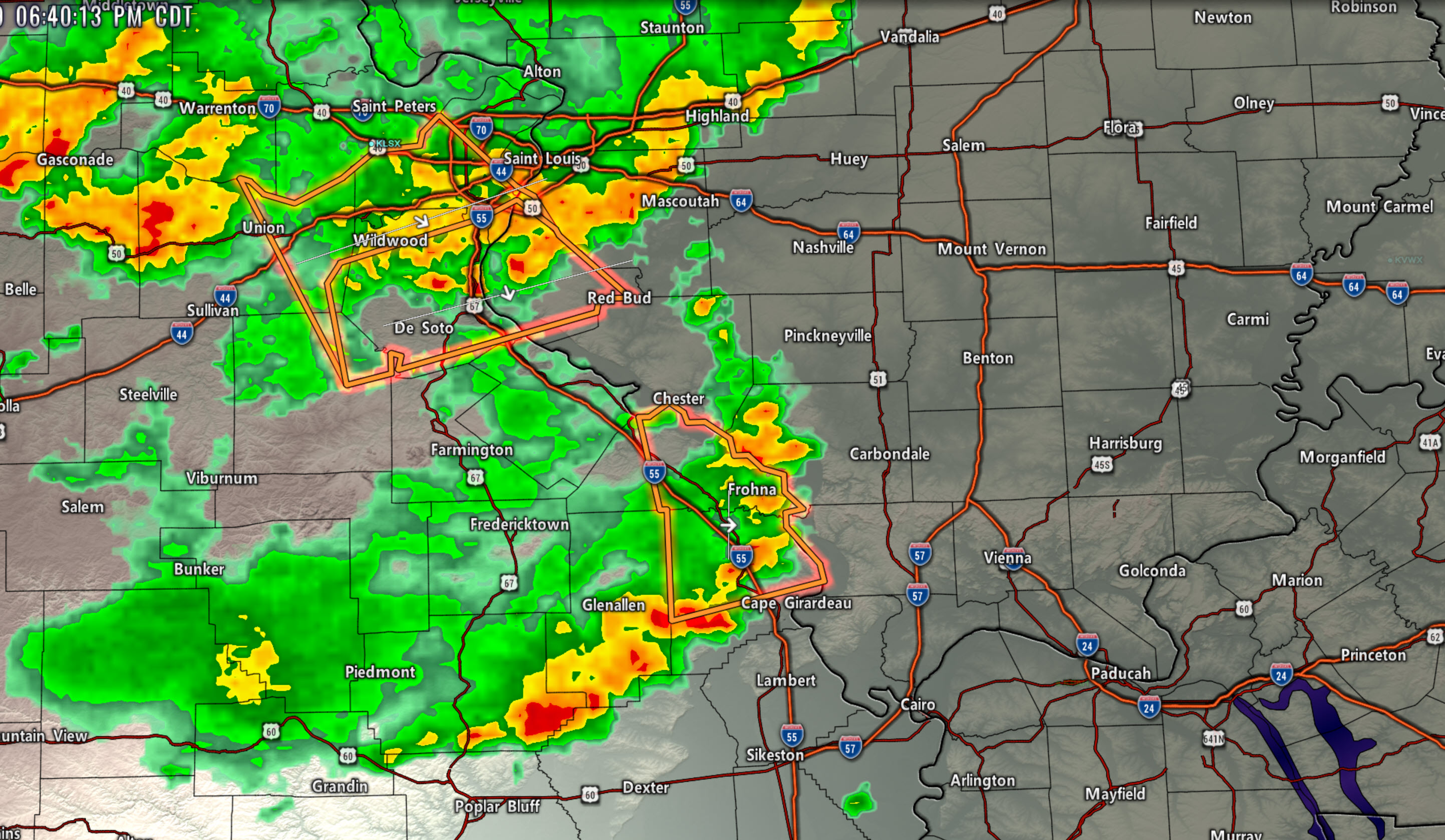
6:41 PM
Two bands of storms. The northern one and the western one. Both moving in different directions.
Click to enlarge.
.
6:38 PM
Ste Gene County, MO. Randolph/Perry County, IL. Strong storms approaching from the N NW. Pockets of high winds are possible. Small hail and frequent lightning/heavy rain. Isolated wind damage.
.
6:25 PM
Butler, Stoddard, Scott, Alexander, Union, Jackson Counties. Incoming storms could produce pockets of 50 mph wind. Torrential downpours. They are slowly moving east/southeast at 10 to 20 mph.
.
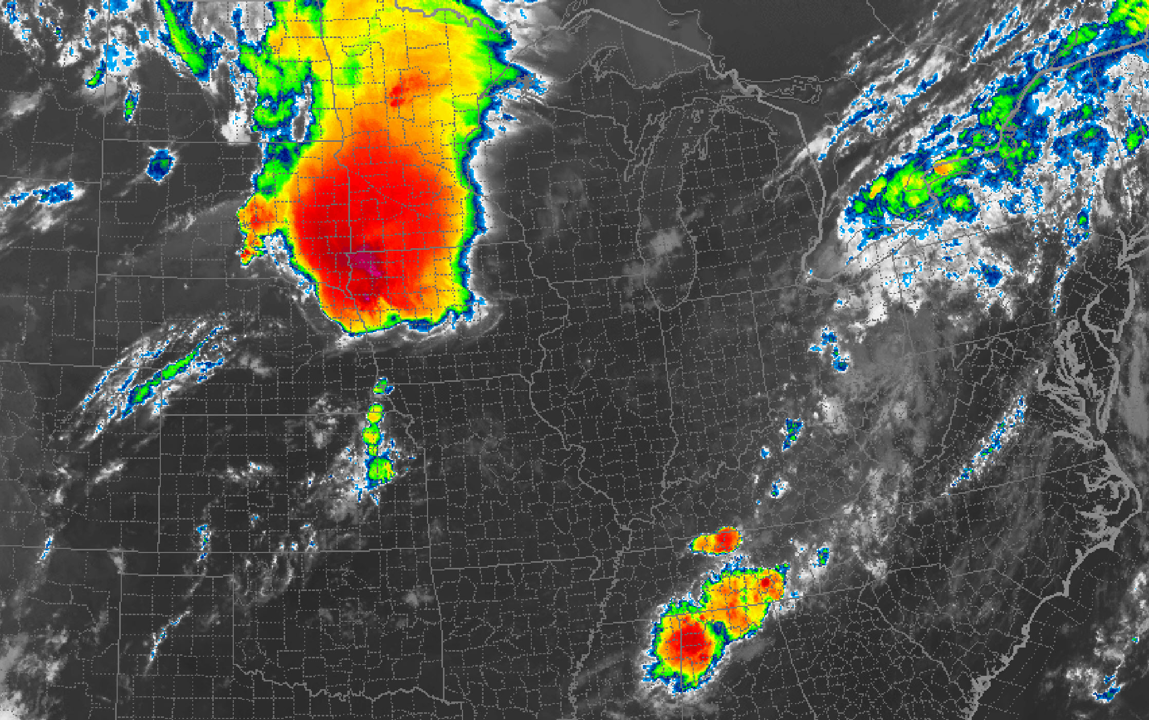
6:19 PM
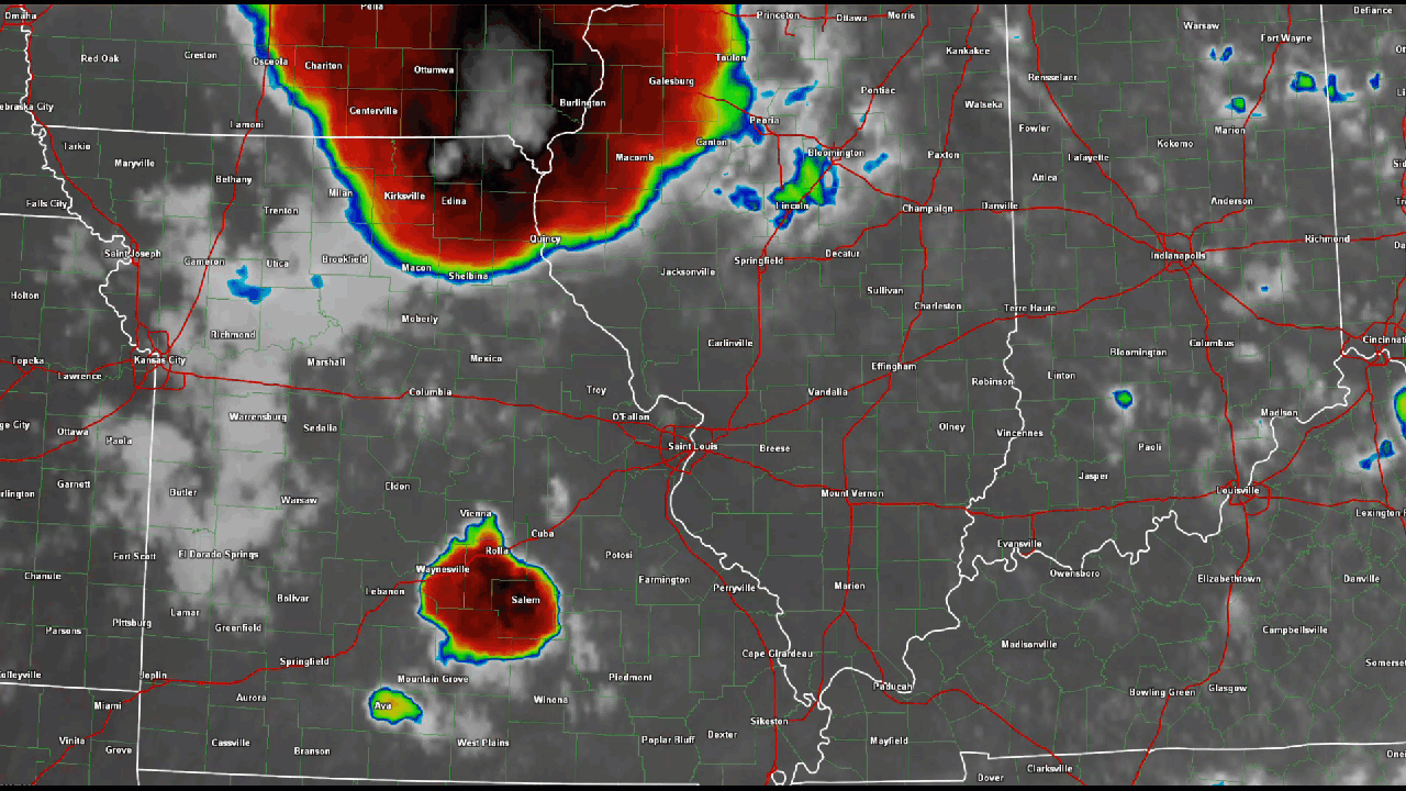
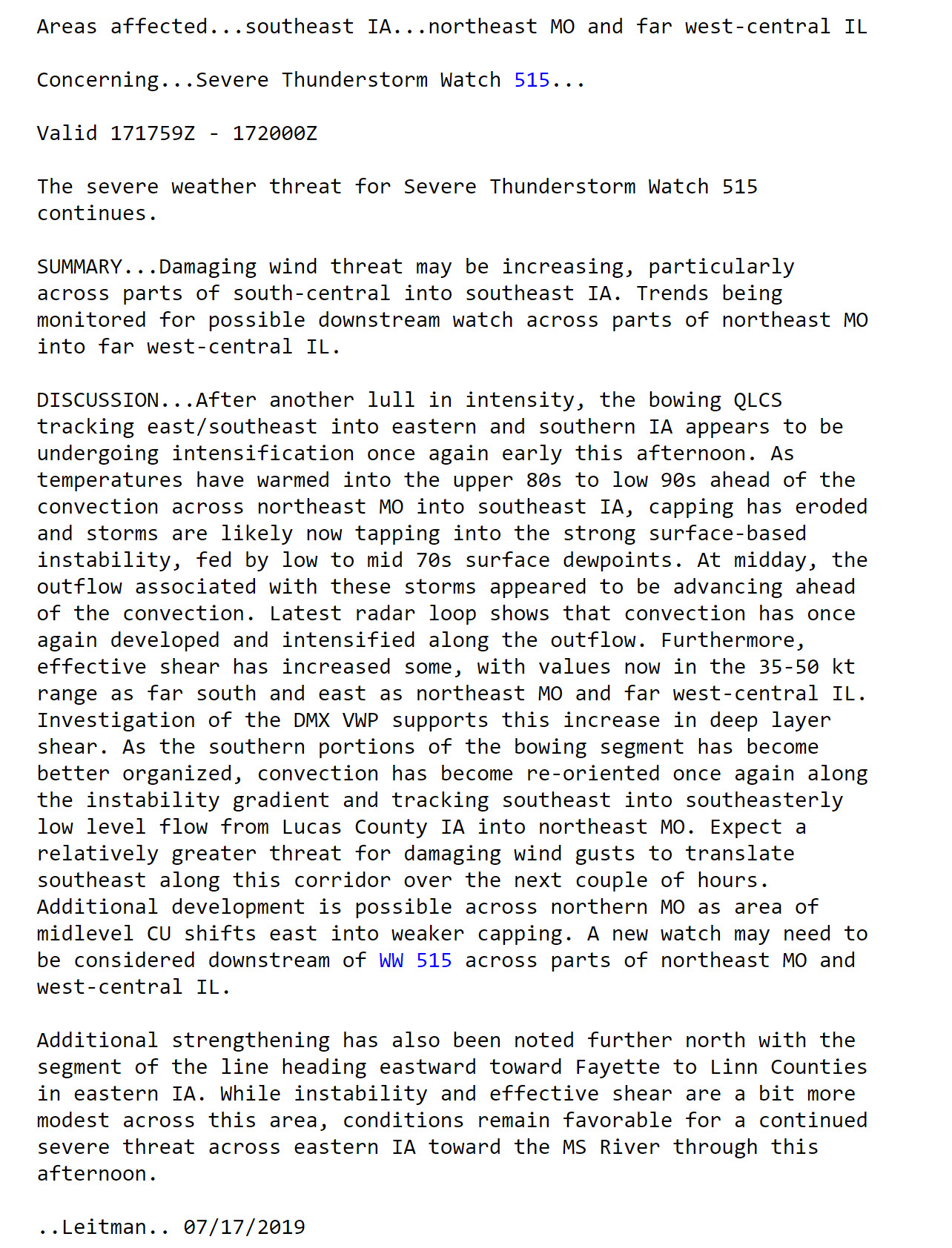
IR satellite view of our two thunderstorm complexes. The northern one came out of Iowa. The western one formed in central Missouri.
Colors represent temperature. Very cold cloud tops. Those are cumulonimbus clouds. Thunderstorms. The white inside the black colors are the highest storm tops. Higher usually means more intense. Lot of energy to work with today.
Wind shear isn't impressive. Thus, the storms are slow movers (western ones).
You can see the merger of the two complexes.
Click to enlarge
.
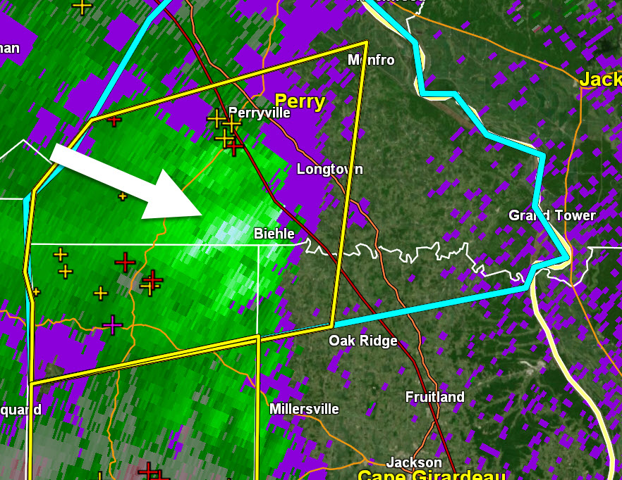
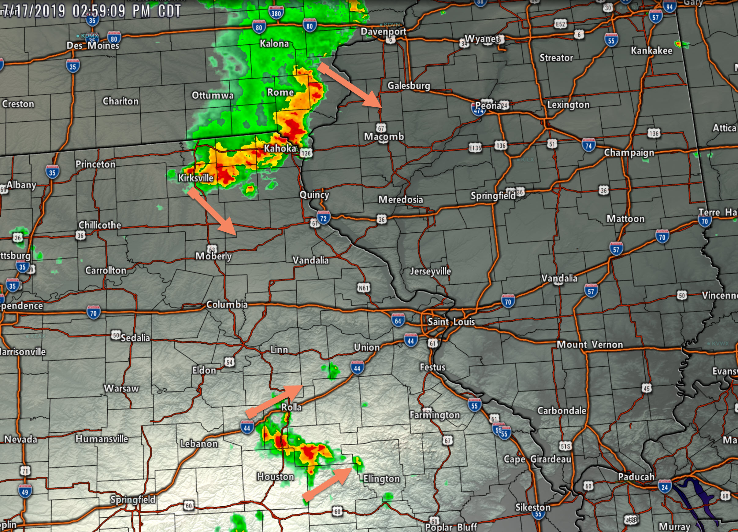
6:03 PM
Radar shows high winds on the Perry, Cape Girardeau, and Bollinger County line. Winds may top 55 mph.
That white arrow is pointing at the high wind zone. Slowly moving east/southeast.
.
5:44 PM
Cape Girardeau County. Storms approaching from the west and north will produce torrential rain, small hail, and isolated wind damage. They will first enter the western and northern part of the county. They will then track E SE.
.
5:40 PM
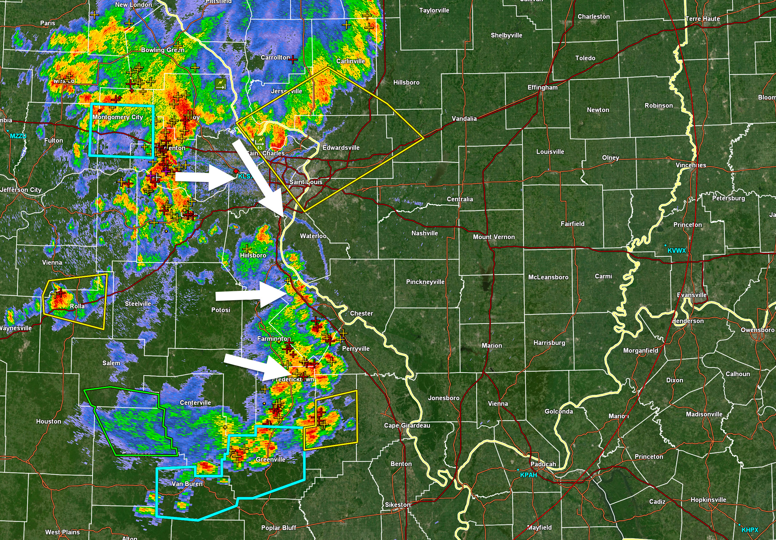
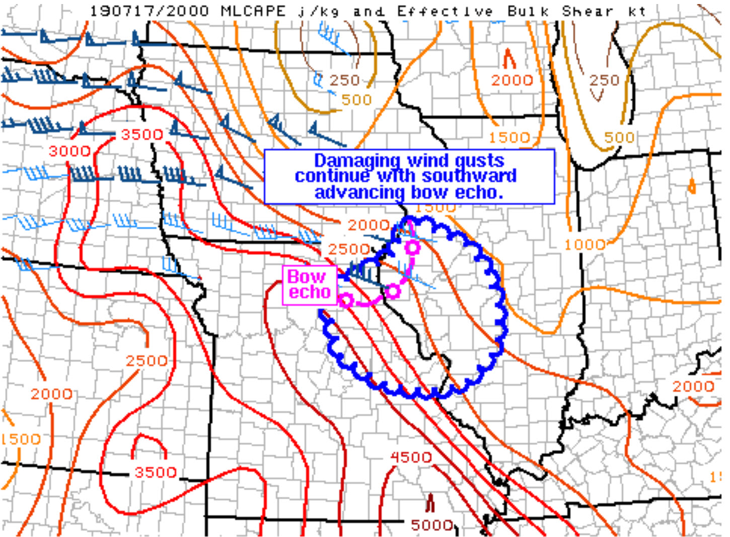
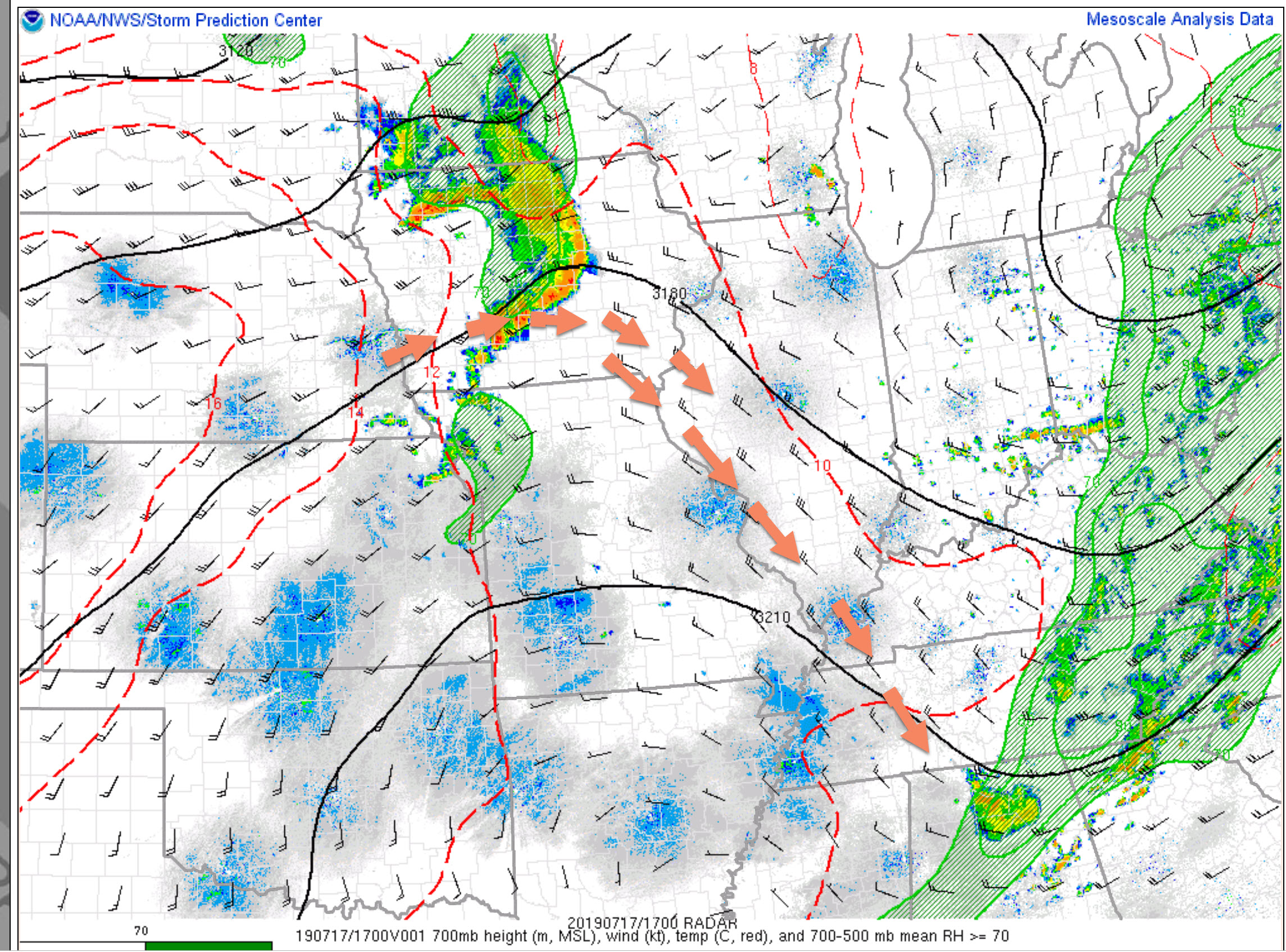
There are two thunderstorm complexes moving into and through the region.
The northern one is about to enter St Louis. These are the storms that were in Iowa earlier today.
Another complex formed in central Missouri and has moved eastward.
There are multiple outflow (pushes of rain cooler wind/air) boundaries moving out ahead of each complex.
This is complicating the unstable environment.
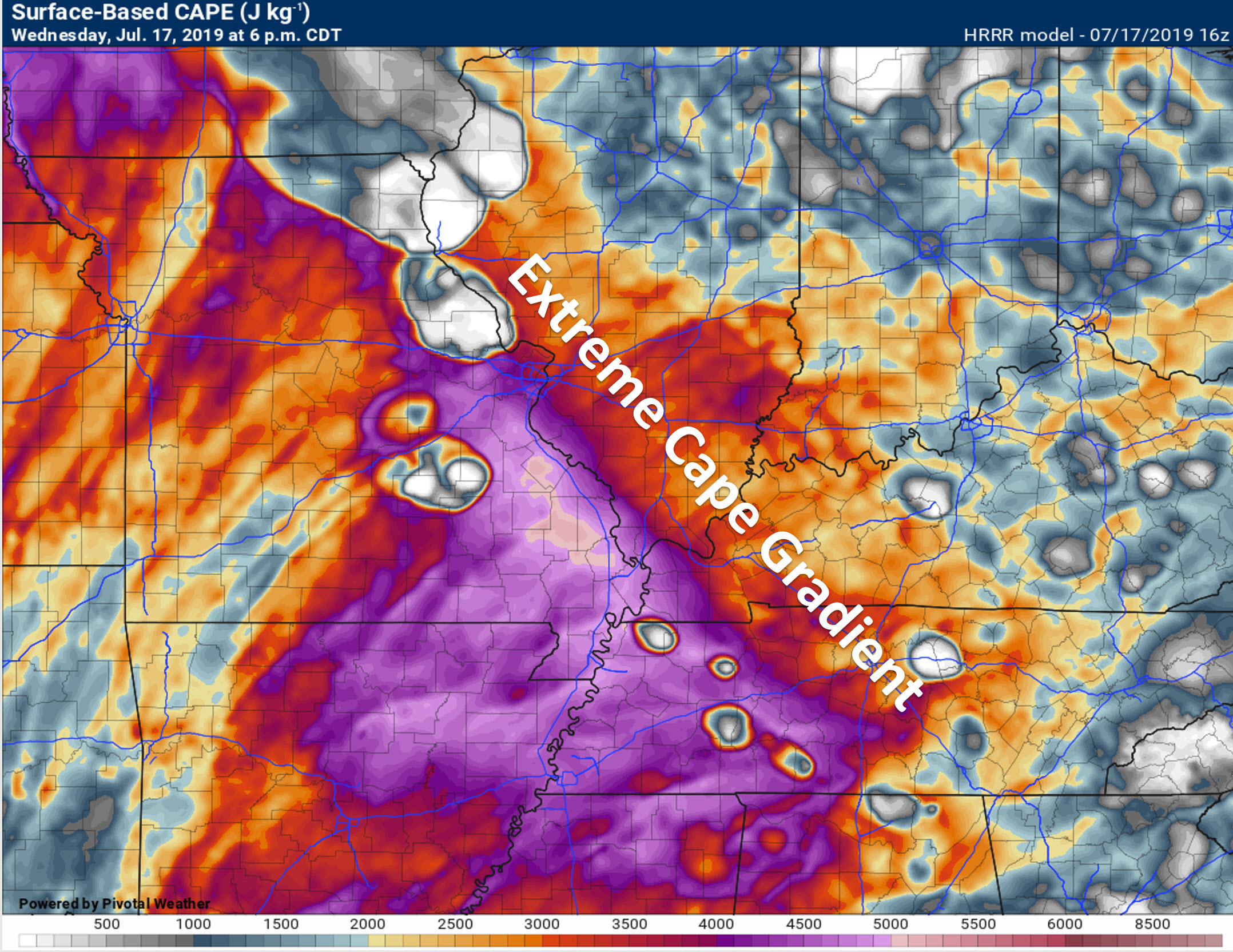
CAPE (energy for storms to tap into) numbers are in the 2500 to 4000 range. That is high.
The outflow boundaries, however, may cause the northern line of storms to weaken some as it enters our northern counties.
It is possible that the mergers will eventually form one main-line. That would increase the wind damage threat.
For now, these storms are producing torrential rain, quarter size hail, and some high winds.
Monitor warnings over the next couple of hours.
The storms will likely make it into southern Illinois. How far south and east from there remains a question.
The arrows represent the direction of the storms.
.
5:38 PM
Perry County, MO. Approaching storms will produce torrential downpours. Pockets of damaging wind and hail are also possible. Moving in from the west/northwest.
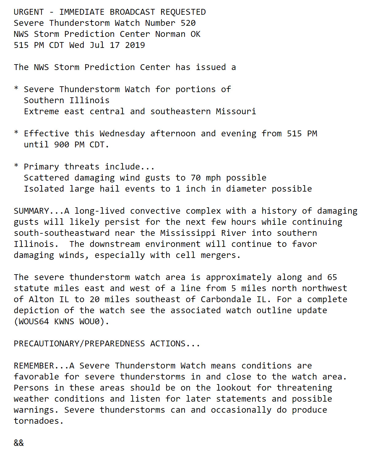
5:30 PM
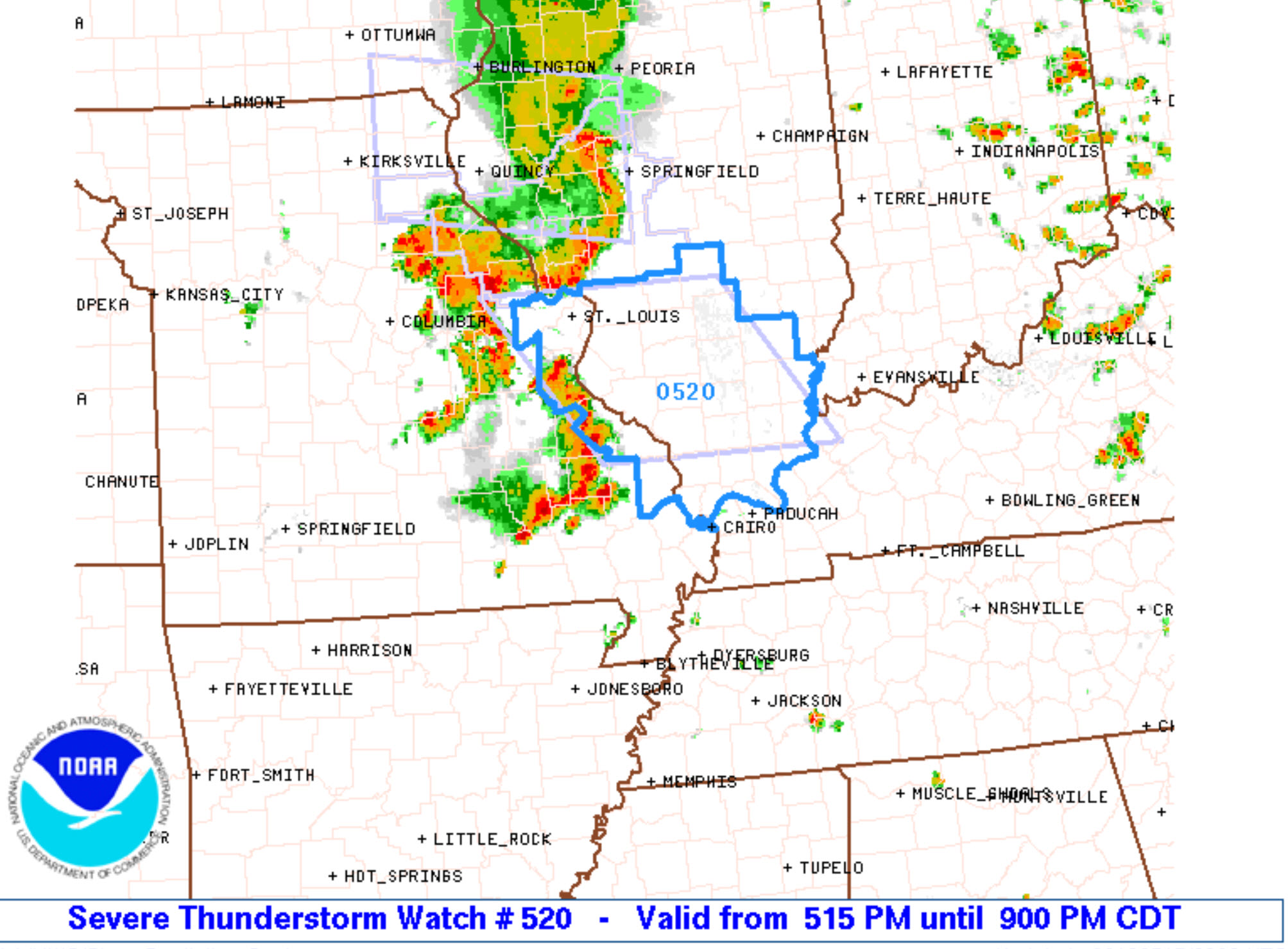
A severe thunderstorm watch has been issued.
Two lines of thunderstorms are moving into the region. Both could produce high wind and possibly some hail.
Click to enlarge.
5:27 PM
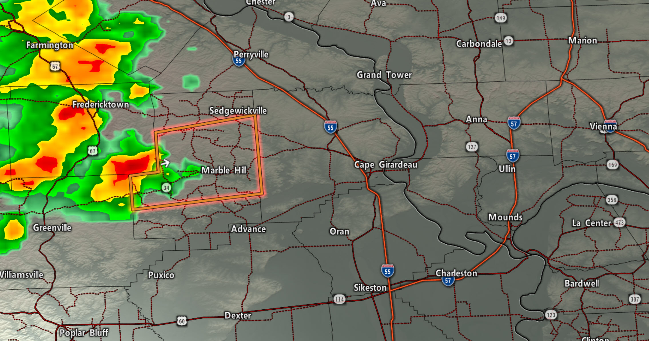
A slow-moving storm is entering central Bollinger County from the west. It may produce quarter size hail and high winds. Movement is east at 15 mph.
Radar link http://weatherobservatory.com/radar_cape.htm
.
4:30 pm
Radar
https://imagery.weathertalk.com/prx/RadarLoop.mp4
.
Radar. Click to enlarge.
.
4:05 PM
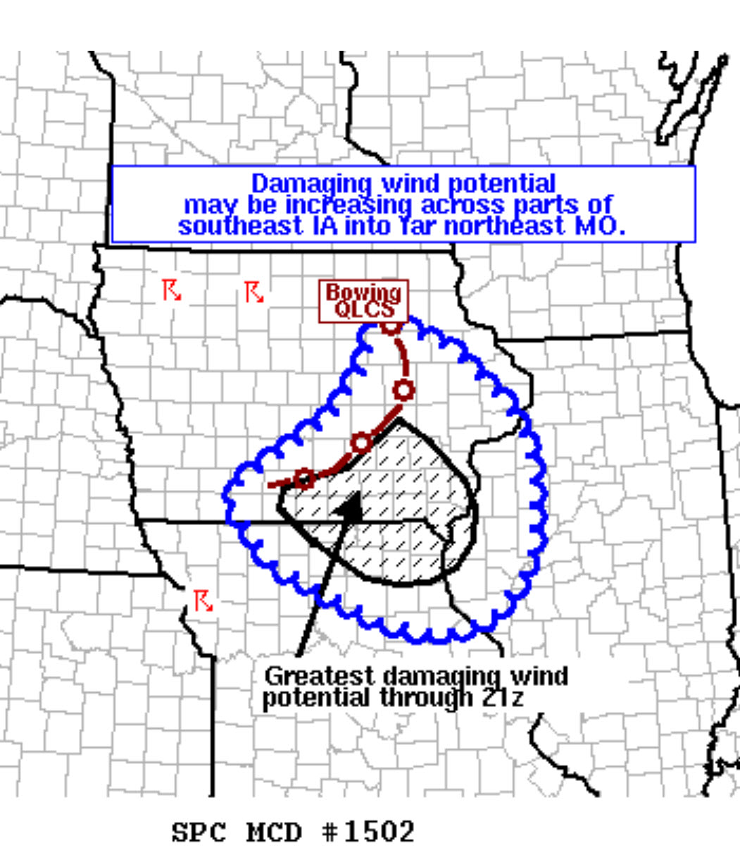
SPC update.
They are saying the line of storms will continue to move southeast. Damaging wind is the concern.
The blue squiggly line is where this discussion covers.
Once you get past the blue squiggly line there is some question as to how far south it will push.
Click to enlarge.
.
2:53 PM
BAMwx team has updated the video for Illinois and Ohio Valley.
Here are the storms.
One complex is forming in central Missouri. Another complex is now moving south and southeast out of Iowa.
The question is how long do these storms survive.
That remains a question.
The storms will continue to track towards our region. I am monitoring to see how long they maintain their strength.
For most of us, it would be later this evening and tonight before they arrive.
Click to enlarge.
Click images to enlarge.
.
2:10 PM
The storms in Iowa would not arrive here until later this evening.
I am watching to see if the storms in Missouri increase and then anything ahead of the Iowa line.
.
1:14 PM
SPC update
Click to enlarge
Click to enlarge
.
1:07 PM
IR and visible satellite show the complex of thunderstorms in Iowa. The colors represent temperatures. Very cold cloud tops. Thunderstorms!
Click the image.
and weather radar
Radar Link: Interactive local city-view radars & regional radars.
.
12:30 PM
Good afternoon.
There is a risk of severe weather today. This is not a slam-dunk forecast. I do believe are going to see thunderstorms.
The greatest risk is across southeast Missouri and southern Illinois. From there, we will need to monitor the track of the thunderstorms. If it is a solid line of thunderstorms then it would last longer. A broken line of storms may not make it all the way into Kentucky and Tennessee.
It is a complex forecast today.
A few items of interest.SPC has expanded the threat zone eastward.CAPE is energy.
Here is the Storm Prediction Center's severe weather outlook.
Light green is where thunderstorms may occur but should be below severe levels.
Dark green is a level one risk. Yellow is a level two risk. Orange is a level three (enhanced) risk. Red is a level four (moderate) risk. Pink is a level five (high) risk.
One is the lowest risk. Five is the highest risk.
Light green is not assigned a number. Light green is where storms may occur but should be below severe levels.
A severe storm is one that produces 60 mph winds or higher, quarter size hail, and/or a tornado. One or more of those is defined as a severe thunderstorm.

.
CAPE is what storms tap into. High CAPE numbers could mean severe weather.
Storms like to follow the CAPE gradient. Notice here where the CAPE gradient is.
.
Here are the upper-level winds. This is way up in the atmosphere at the 700 mb level.
The red arrows show the wind direction. Notice the Iowa storms? That is the radar.
Those storms should turn south and east over the coming hours.
I am closely monitoring them.
.
The Hrrr model does show activity moving our way. Does not mean it will verify.
.
12:00 PM update
For now, no concerns. I am monitoring the storms in Iowa and central Missouri.
More storms are likely to form this afternoon and will track south and southeast.
If storms do form then they could be severe.
Continue to monitor updates.
.
10 AM update
Confidence in the track of today's thunderstorm complexes remains low.
Monitor updates throughout the day.
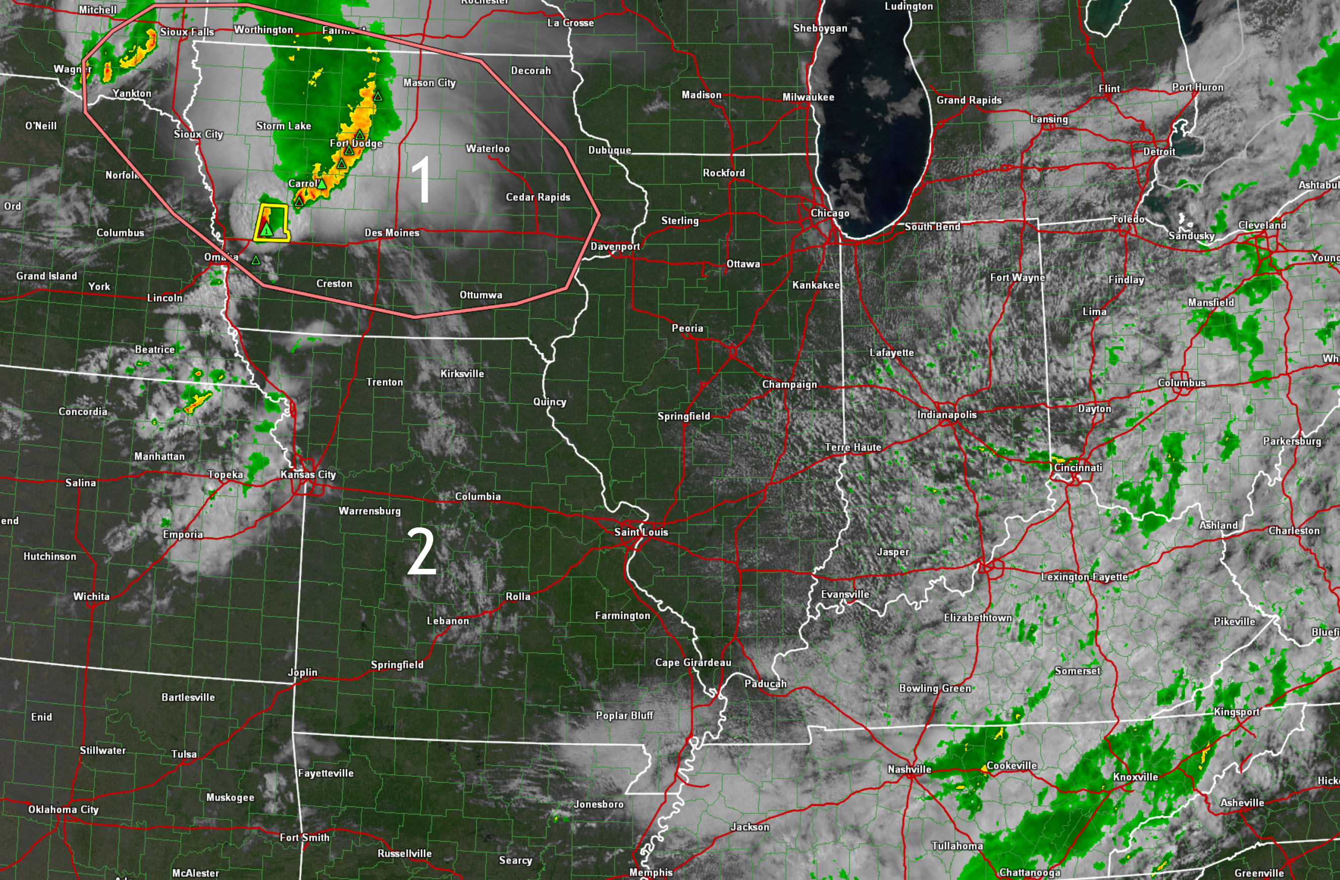
I am watching two zones. One and two.
The Iowa storms would move east and southeast. Perhaps eventually south.,
Zone two in Central Missouri is where new storms may develop over the coming hours. Those would move south/southeast.
Click images and animations to enlarge them.
.
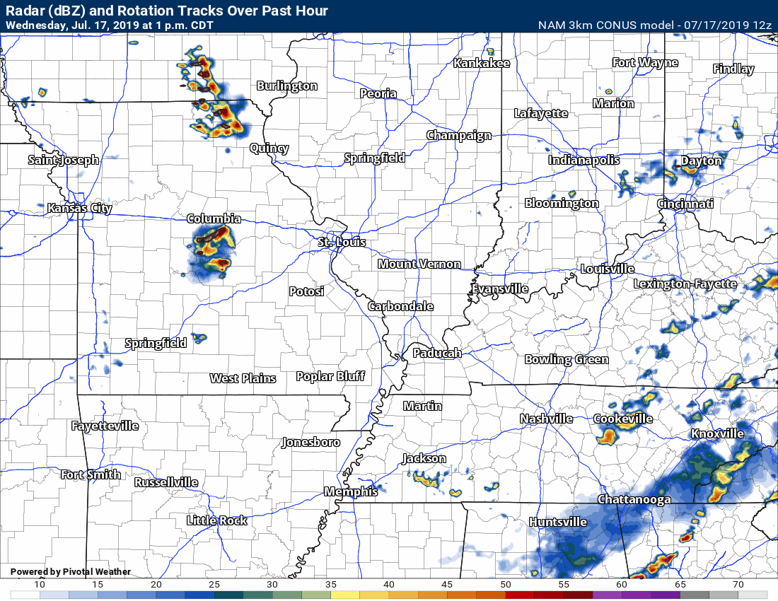
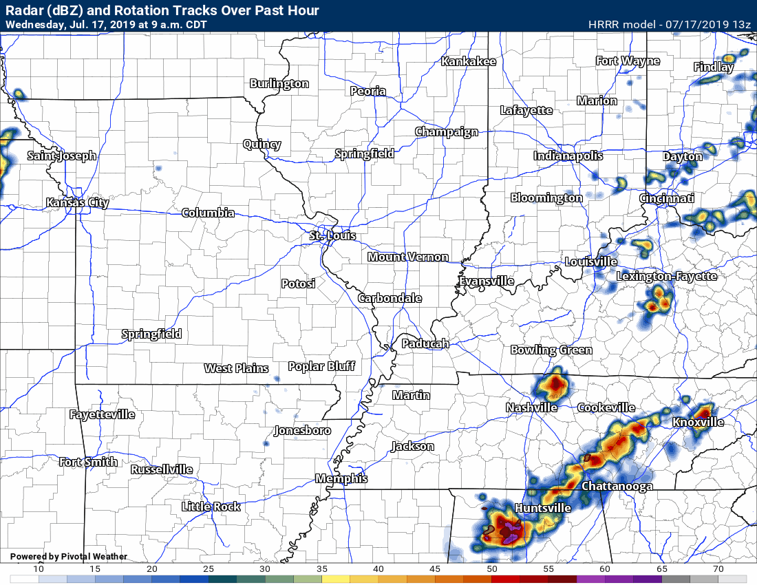
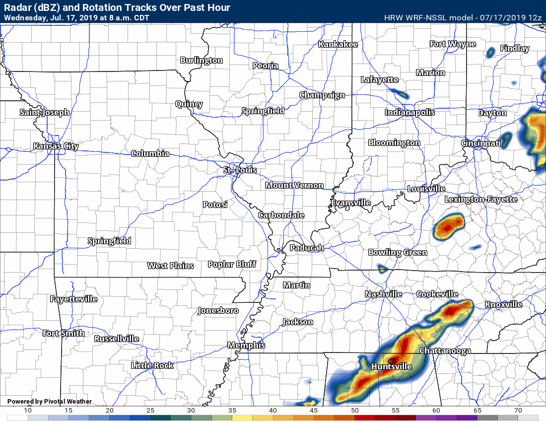
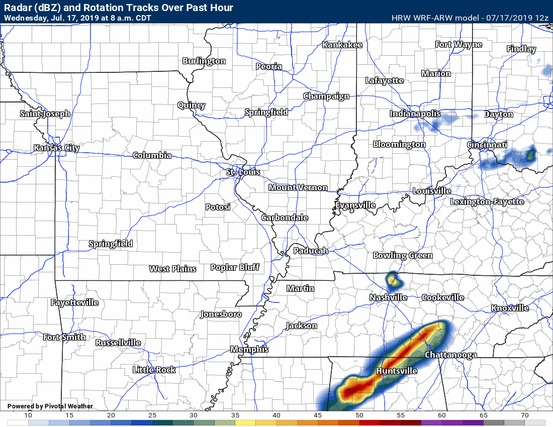
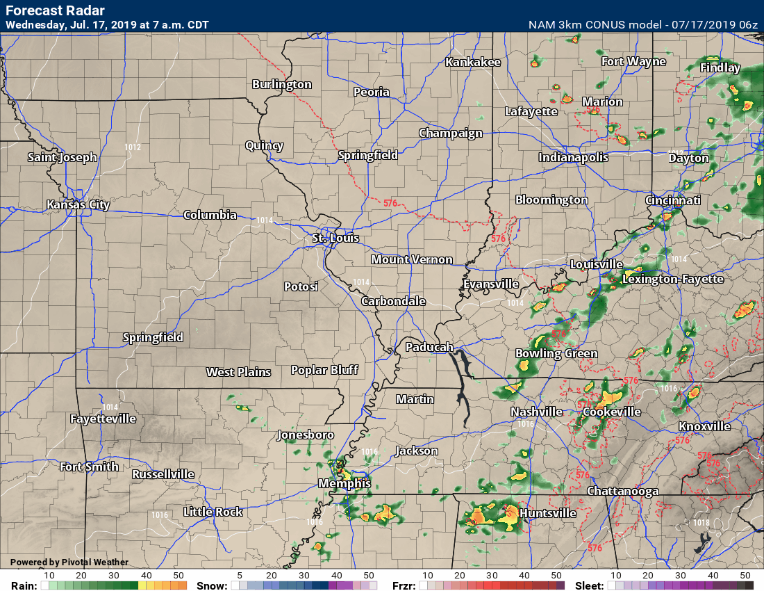
You can see that the high-resolution models favor southeast Missouri for the greatest chance of thunderstorm activity.
The NAM 3K model
Click animations to enlarge them.
.
.
The regular Hrrr model
.
The SPC WRF model.
Click to enlarge.
.
.
The ARW WRF model
click to enlarge
.
High heat values today through Sunday. Heat index values, outside of clouds and storms, will top 100 degrees.


.
I am keeping this up today because of additional thunderstorms.
A complex of thunderstorms is forecast to dive into our region from Iowa and Missouri later today.
There are questions about the exact track of the system.
Damaging wind and hail will be possible with the most intense thunderstorms.
The SPC has outlined portions of the region for a severe weather risk.
Areas to the east should also monitor updated forecasts.
This is one of the areas I am monitoring. This is a complex of thunderstorms that is moving across Iowa.
It is likely to turn south and southeast as the day wears on.
Additional thunderstorms may also form in Missouri in response to an upper-level wave.
Click the image to enlarge it.
IR Satellite Imagery
You are looking at clouds. The colors represent temperature. The red colors are cold temperatures. Those are the tops of thunderstorms.
.
Let's look at some models.
Each model shows a different scenario. This does not add confidence to the overall forecast.
Summer thunderstorm complexes are difficult to forecast.
The NAM 3K model
Click animations to enlarge them.
.
.
The regular NAM model
.
The Hrrr model.
Click to enlarge.
.
.
The SPC WRF model
click to enlarge
.
Today's SPC severe weather outlook (below).
Light green is where thunderstorms may occur but should be below severe levels.
Dark green is a level one risk. Yellow is a level two risk. Orange is a level three (enhanced) risk. Red is a level four (moderate) risk. Pink is a level five (high) risk.
One is the lowest risk. Five is the highest risk.
Light green is not assigned a number. Light green is where storms may occur but should be below severe levels.
A severe storm is one that produces 60 mph winds or higher, quarter size hail, and/or a tornado. One or more of those is defined as a severe thunderstorm.
.
.
Tuesday, July 16, 2019
4:20 PM
The severe risk is low the rest of today/tonight. Heavy rain will continue where thunderstorms do occur.
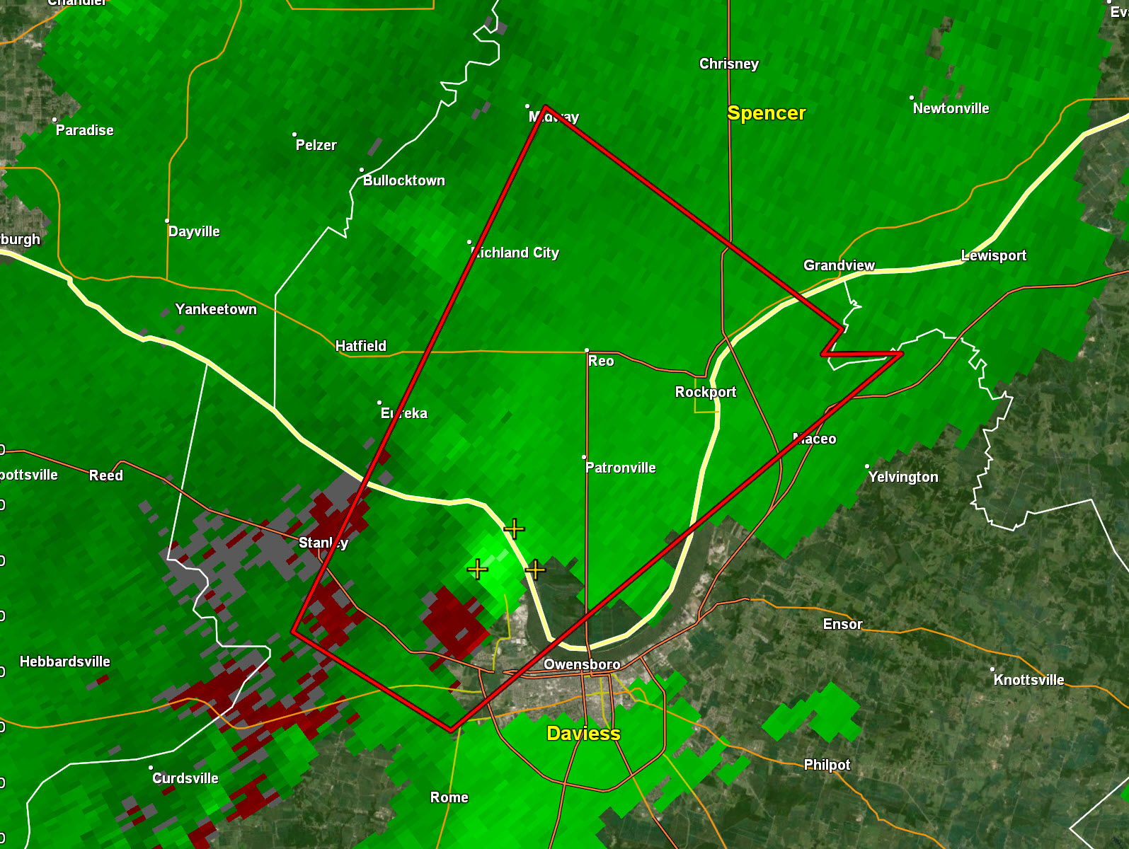
2:03 PM
New tornado warning for Daviess but the rotation is out of the county.
.
1:46 PM
Daviess County. The tornado warning has expired. The rotation has weakened.
1:39 PM
There is stronger wind shear in western Kentucky vs Illinois & Missouri.
The Kentucky storms have all had some rotation.
With that said, all areas need to continue to monitor updates.
1:35 PM
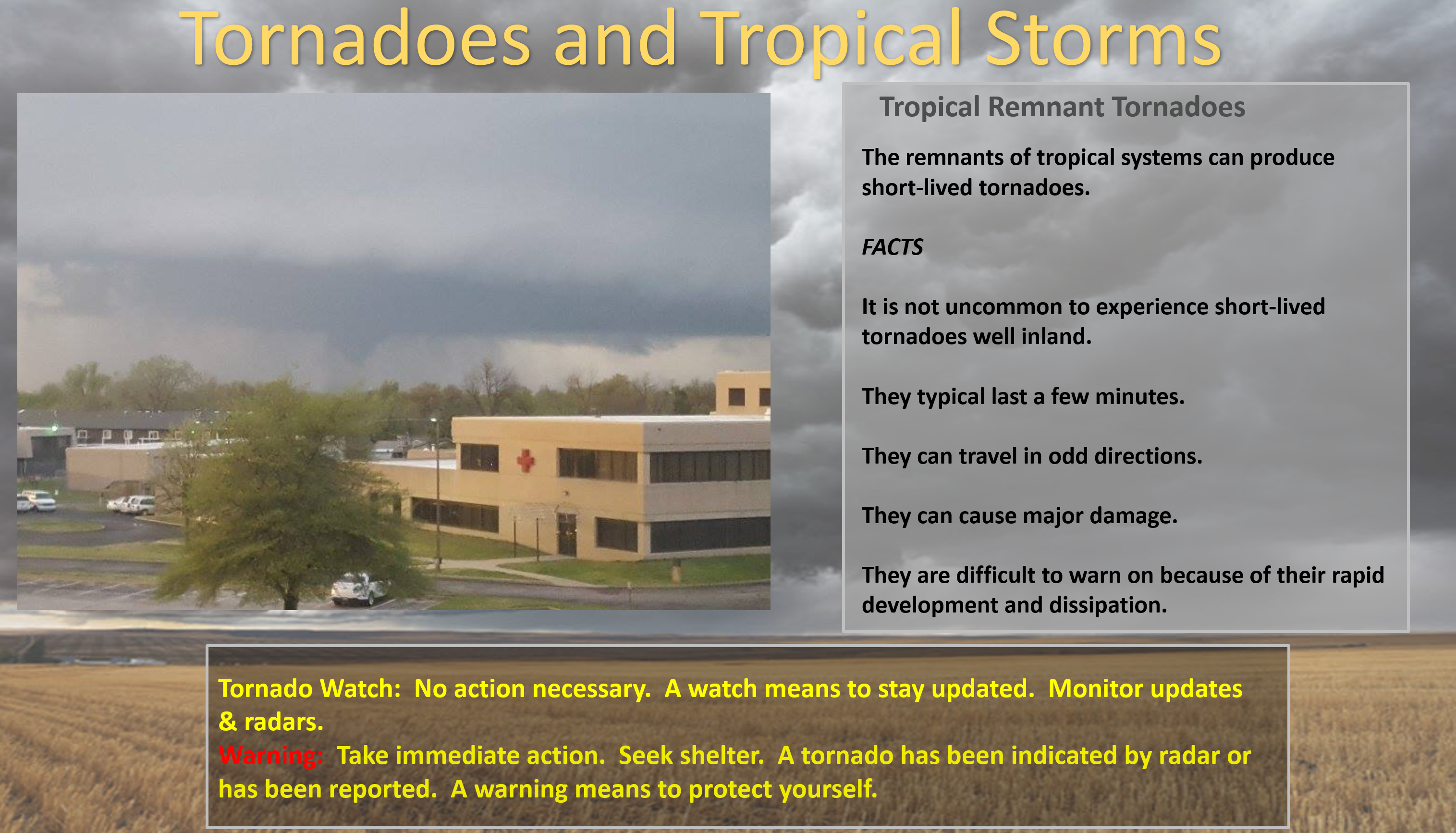
Randolph, Perry, Jackson, Jefferson, & Franklin. Storms over the coming hours might rotate. These are from Tropical Storm Barry. Occasionally, these storms produce short-lived tornadoes. Monitor updates.
Radar
http://weatherobservatory.com/radar_marion.htm
1:27 PM
Far northern Daviess County. The storm may cross back into the county near Rockport, IN. The rotation is weaker but stay alert.
1:23 PM
Daviess County. The tornado warned storm is now crossing the Ohio River. It will soon exit the county. Be weather aware as more storms are likely today.
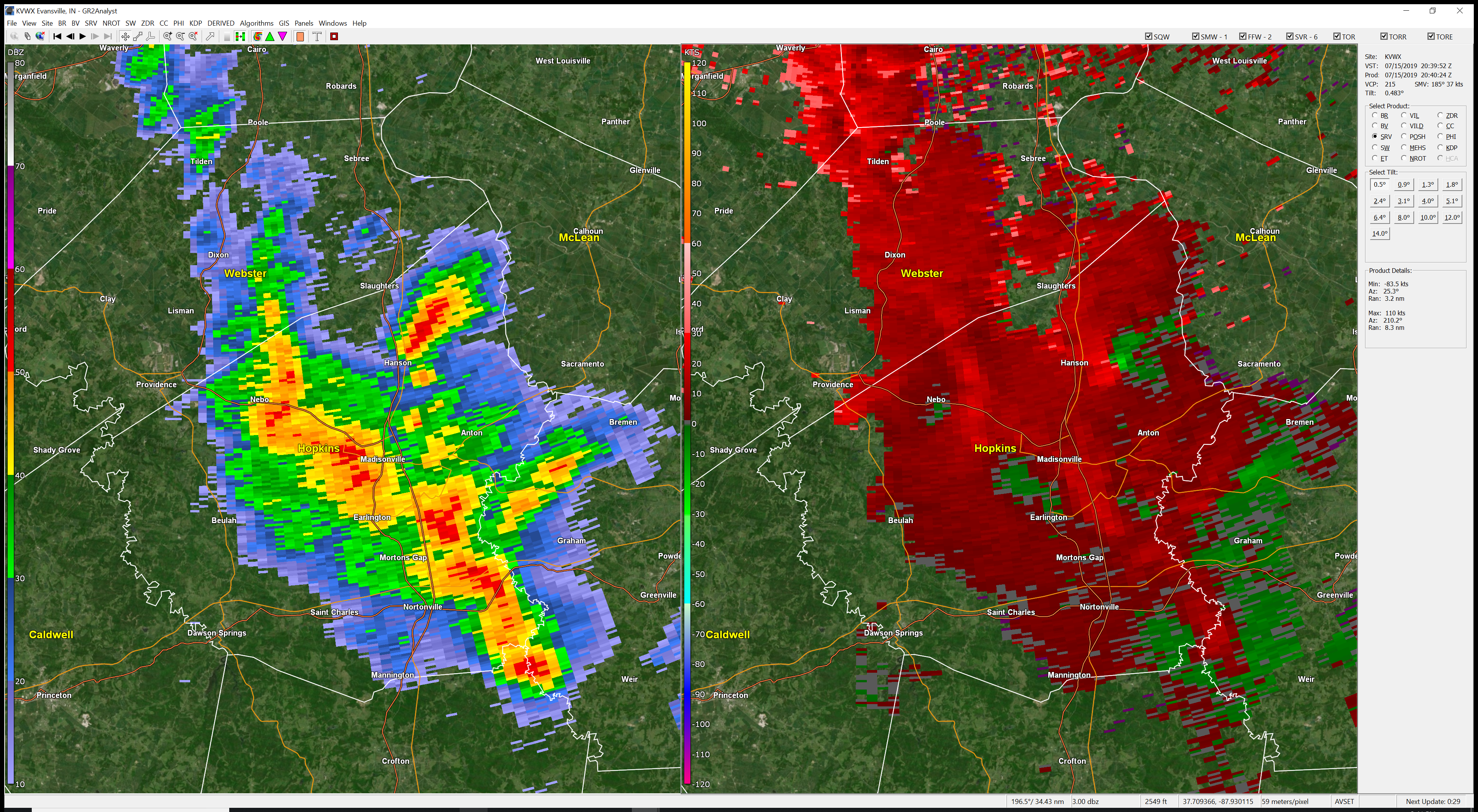
1:18 PM
You can clearly see the rotation near Owensboro, KY. It is moving NE. Red on gree is the rotation zone.
.
1:16 PM
Webster County. The tornado warning has expired. There is still weak rotation. Just be weather aware.
.
1:14 PM
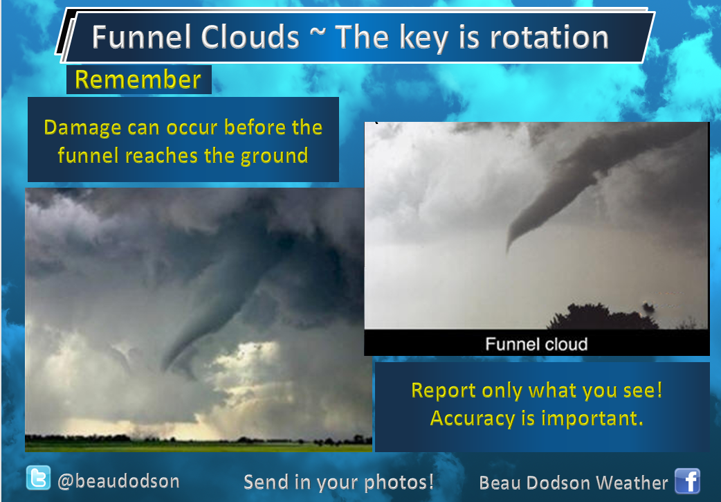
Local Storm Report by NWS PAH: 2 SE Dixon [Webster Co, KY] trained spotter reports FUNNEL CLOUD at 01:03 PM CDT
.
1:13 PM
NWS issues Tornado Warning [tornado: RADAR INDICATED, hail: <.75 IN] for Daviess [KY] and Spencer [IN] till 1:45 PM CDT ...AT 113 PM CDT, A SEVERE THUNDERSTORM CAPABLE OF PRODUCING A TORNADO WAS LOCATED NEAR STANLEY, OR NEAR OWENSBORO, MOVING NORTHEAST AT 30 MPH.
.
1:08 PM
Update: Webster County rotation is weaker and weaker. Still some rotation.
Update. Daviess County. Area of radar indicated rotation is passing just a tad W NW of Owensboro. It may clip the NW part of the city.
Live Radar
http://weatherobservatory.com/radar_evans.htm
.
1:07 PM
Hopkins County. The rotation area is north of your county. At this time, I am not concerned about anything in your county.
.
1:04 PM
NWS continues Tornado Warning [tornado: RADAR INDICATED, hail: <.75 IN] for Hopkins, Webster [KY] till 1:15 PM CDT ...AT 103 PM CDT, A SEVERE THUNDERSTORM CAPABLE OF PRODUCING A TORNADO WAS LOCATED NEAR DIXON, OR 12 MILES NORTHEAST OF PROVIDENCE, MOVING NORTHEAST AT 30 MPH.
.
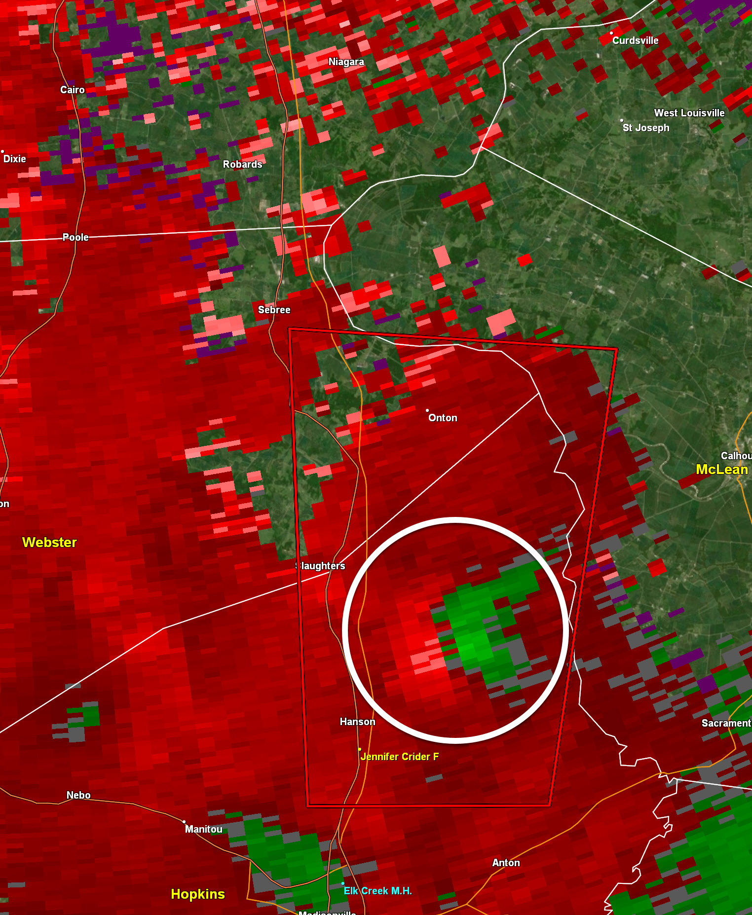
1:03 PM
Rotation is not as strong but is still there. It will pass near Sebree on its current path. Be weather aware as this storm approaches.
.
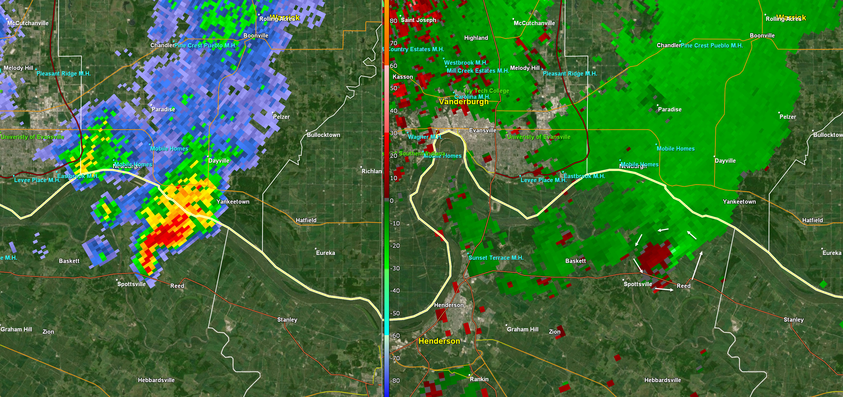
12:55 PM
Daviess County. An area of stronger rotation is now located near St. Joseph & West Louisville and it moving NE at 30 mph. Seek shelter until the storm passes.
Webster and along the Webster/Hopkins County line.
Moving NE at 30 mph. Be aware.
Arrows show the rotation.
The red box is the tornado warning. Green box is a flood advisory.
12:36 PM
Calloway County. Be aware of incoming storms. Some of the storms have rotation.
Right now one is located in extreme SW Calloway County. Moving NE.
Tropical systems can produce short-lived tornadoes. Just be weather aware.
Also,
Caldwell, Eastern Henderson, eastern Webster, Daviess, McLean, Hopkins, Muhlenberg.
Storms are moving E NE at 30 mph.
Some occasionally have rotation. Be aware as storms move through your area.
.
12:10 PM
Extreme NE Henderson County.
The storm with rotation is now crossing the Ohio River into Indiana.
There could be more storms today. Monitor updates.
.
12:07 PM
Extreme NE Henderson County.
A storm with rotation is about to exit into Indiana.
It is NE of Spottsville and Reed (towns). Moving NE 30 mph. It will soon exit the county.
You can see the rotation on radar.
.
11:47 AM
Small supercell in Henderson County, KY is trying to rotate. So far, it has not produced a tornado. It is weak rotation.
I am monitoring it as it moves N NE at 30 mph.
.
8:00 AM
Another day with showers and heavy thunderstorms.
The atmosphere will be a bit more unstable today. That means intense storms are possible with a few reports of damaging wind and short-lived tornadoes.
Monitor updates.
.
Monday, July 15, 2019
4:35 PM
Eastern Henderson into Daviess County. Radar shows the potential of damaging wind gusts. Highest winds SW of Stanley, KY. Movement N at 25.
.
3:59 PM
The rotation has weakened considerably. Tropical storm tornadoes tend to be short-lived. Stay weather aware. These storms could also produce patchy wind damage.
.
3:56 PM
Rotation is weakening. Tropical storm tornadoes tend to be short-lived.
.
3:54 PM
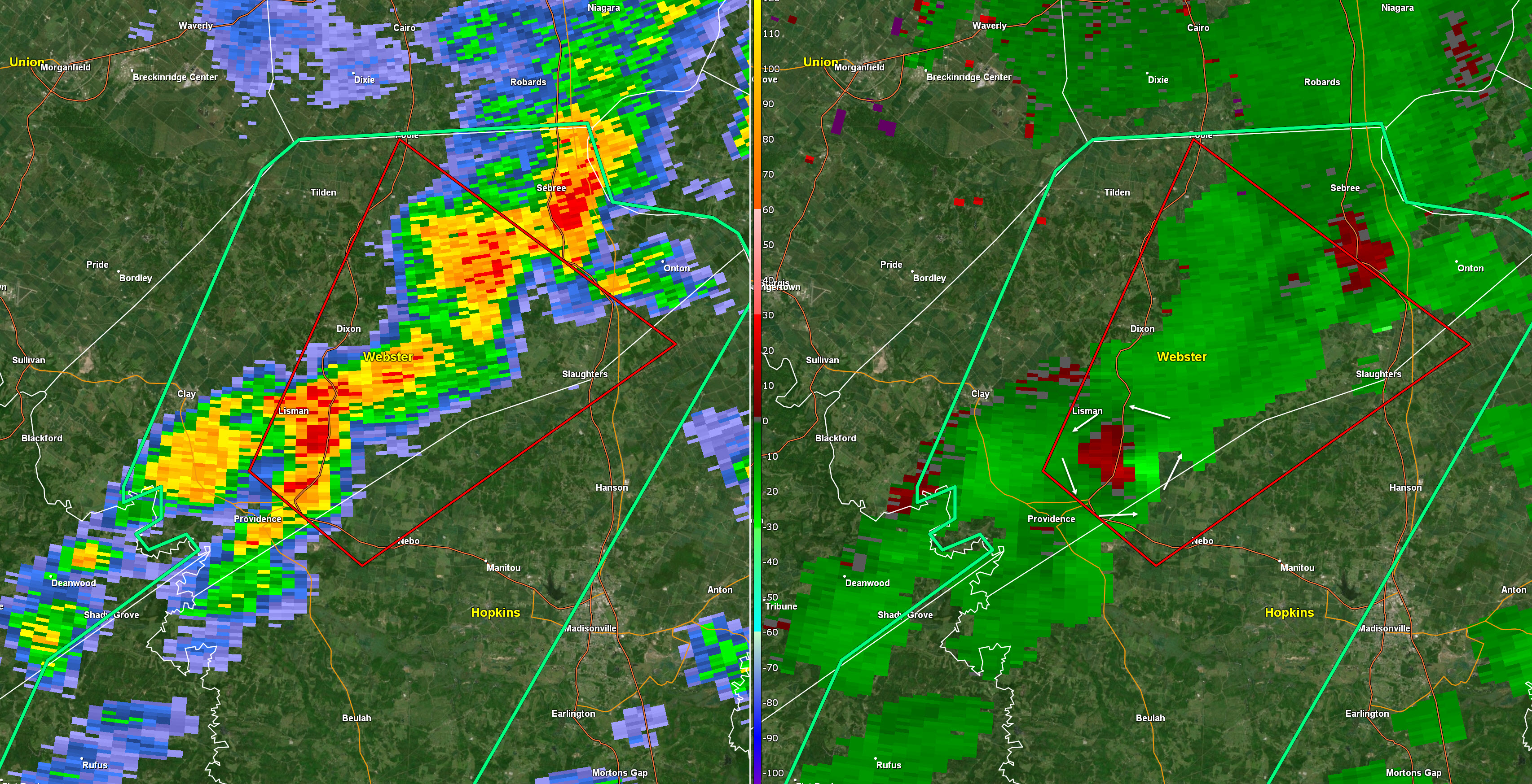
Radar shows a poss tornado nearing the Webster/Hopkins/McLean County line just east of Slaughters, KY. Movement N at 25 mph. Be alert. Henderson and Daviess your counties be aware.
.
3:48 PM
Live radar
http://weatherobservatory.com/radar_evans.htm
Radar shows a poss tornado NE of Hanson, KY. Next areas will be near or east of Slaughter, KY and near Onton, KY. Movement is N at 20 to 30 mph. Seek shelter.
I circled where the tornado might be.
.
3:46 PM
Spotters are reporting a wall cloud and a funnel cloud in Hopkins County, KY.
.
3:42 PM
Rotation is now passing near or just east of Hanson, KY. N NE part of Hopkins County moving N at 30 to 35 mph.
The red on green is the rotation (right image).
.
3:36 PM
Western McLean, eastern Webster, northern Hopkins. A storm with rotation near Hanson, KY in Hopkins County. Moving N at 30 mph. Be prepared to seek shelter.
.
3:34 PM
Union, Henderson, Daviess Counties in western KY. Monitoring storm cells moving in from the south.
Some of them could produce gusty winds. Will monitor the tornado risk.
.
2:35 PM
Some breaks in the clouds over western Kentucky.
I am monitoring storms in Christian County as they move north and northwest.
Radars
http://weatherobservatory.com/radar_hoptown.htm
.
2:52 PM
Crittenden, Webster, McLean, Lyon, Caldwell, Hopkins, Muhlen, Trigg, Christian, & Todd counties.
A few thunderstorms this afternoon could rotate.
Tropical systems occasionally produce brief tornadoes. They can occur with little or no warning.
Be weather aware.
.
2 PM Update
No change. Clouds and rain are keeping instability down.
Widespread 70s across the region! Some locations in the lower 70s. Those are record low high temperatures.
Clouds have thinned over eastern Arkansas. That is the best area for thunderstorm development.
For now, our region remains solidly in the clouds. As long as that continues, the risk of tornadoes will remain small.
I am a bit more concerned about Tuesday. Thunderstorms should form on Tuesday and perhaps Wednesday.
Instability will be higher both days.
Continue to monitor updates.
.
12 PM Update
I am closely monitoring satellite and radar. If we have breaks in the clouds then CAPE will develop. That increases the risk of severe thunderstorms.
Live satellite link https://imagery.weathertalk.com/prx/GeocolorSatelliteLoop.mp4
Here is what SPC just said. I agree with it.
Lower Mississippi through lower Ohio Valleys
The center of low pressure associated with the remnants of Barry is
currently over AR and will move slowly north today. VWP data still
show large hodographs with 0-1 km storm relative helicity from
300-400 m2/s2 along low-level jet east and north of the center.
However, the primary limiting factor is expected to remain widespread
clouds and moist adiabatic lapse rates which will limit instability
and updraft strength. Nevertheless, a few breaks in the clouds are
evident across southeast AR spreading northward, and additional
cloud breaks might occur farther east. A few low-topped showers and
storms are expected this afternoon, and at least a couple of
tornadoes remain possible given the favorable low-level kinematic
environment. Will maintain MRGL risk category given the
thermodynamic limitations, but trends will continue to be monitored
for a SLGT risk should it begin to appear that more destabilization
will occur than currently anticipated.
On another note:
Heat WED into at least SUN. GFS model guidance breaks the heat next week around TUE/WED with storms. Lot of disagreement in data about that.
.
9:20 AM
The WPC excessive rainfall outlook has placed us in a slight risk today and tomorrow.
What does that mean? It means flash flooding is possible.
Click to enlarge graphics on this page.
Tomorrow

.
8:30 AM Update
A conditional risk of severe thunderstorms today. Conditional means certain parameters need to be met in order for severe storms to develop.
What are those parameters?
Breaks in the clouds.
If we remain cloud all day then the CAPE numbers will remain low. CAPE is basically energy for thunderstorms to tap into.
Heating of the day increases CAPE numbers. Thus, when the sun is out the atmosphere heats up.
If we do have CAPE later today then the risk of short-lived tornadoes will develop.
For now, I am monitoring radars and satellites.
Otherwise, portions of the region received one to three inches of rain over the weekend. Not everyone.
There will be a wide range of rain totals. My going forecast has been a general one to two inches of rain. Then, there will be pockets of much higher totals. Rainfall totals will be enhanced where heavier bands train over the same areas.
If thunderstorms develop then rain totals would be enhanced, as well.
When it is all said and done, a few spots will have ended up with three to five inches of rain.
Keep in mind, portions of western Kentucky received one to three inches of rain Saturday night and early Sunday morning.
Monitor updates today.
I will post updates here on this page from time to time. I will send out app messages if severe weather develops.
.
.
Today's SPC severe weather outlook (below).
Light green is where thunderstorms may occur but should be below severe levels.
Dark green is a level one risk. Yellow is a level two risk. Orange is a level three (enhanced) risk. Red is a level four (moderate) risk. Pink is a level five (high) risk.
One is the lowest risk. Five is the highest risk.
Light green is not assigned a number. Light green is where storms may occur but should be below severe levels.
A severe storm is one that produces 60 mph winds or higher, quarter size hail, and/or a tornado. One or more of those is defined as a severe thunderstorm.
.
6:00 PM
Those wondering about the week ahead.
.
5:22 PM
Tornado threat over the coming 12 hours will be low.
Concern tonight will be locally very heavy rain where some storms train over the same area.
The risk for heavy rain and even isolated tornadoes will be higher on Monday.
.
3:15 PM
A clear example of a spinning storm. Memphis, TN NWS radar. I drew a circle around the tornado threat zone. Red on green.
This warning is just to our south.
Click to enlarge.
.
2:30 PM
Latest radar trends show heavy rain moving into the Missouri Bootheel, northwest Tennessee, and southwest Kentucky.
This rain is spiraling around the center of Barry.
.
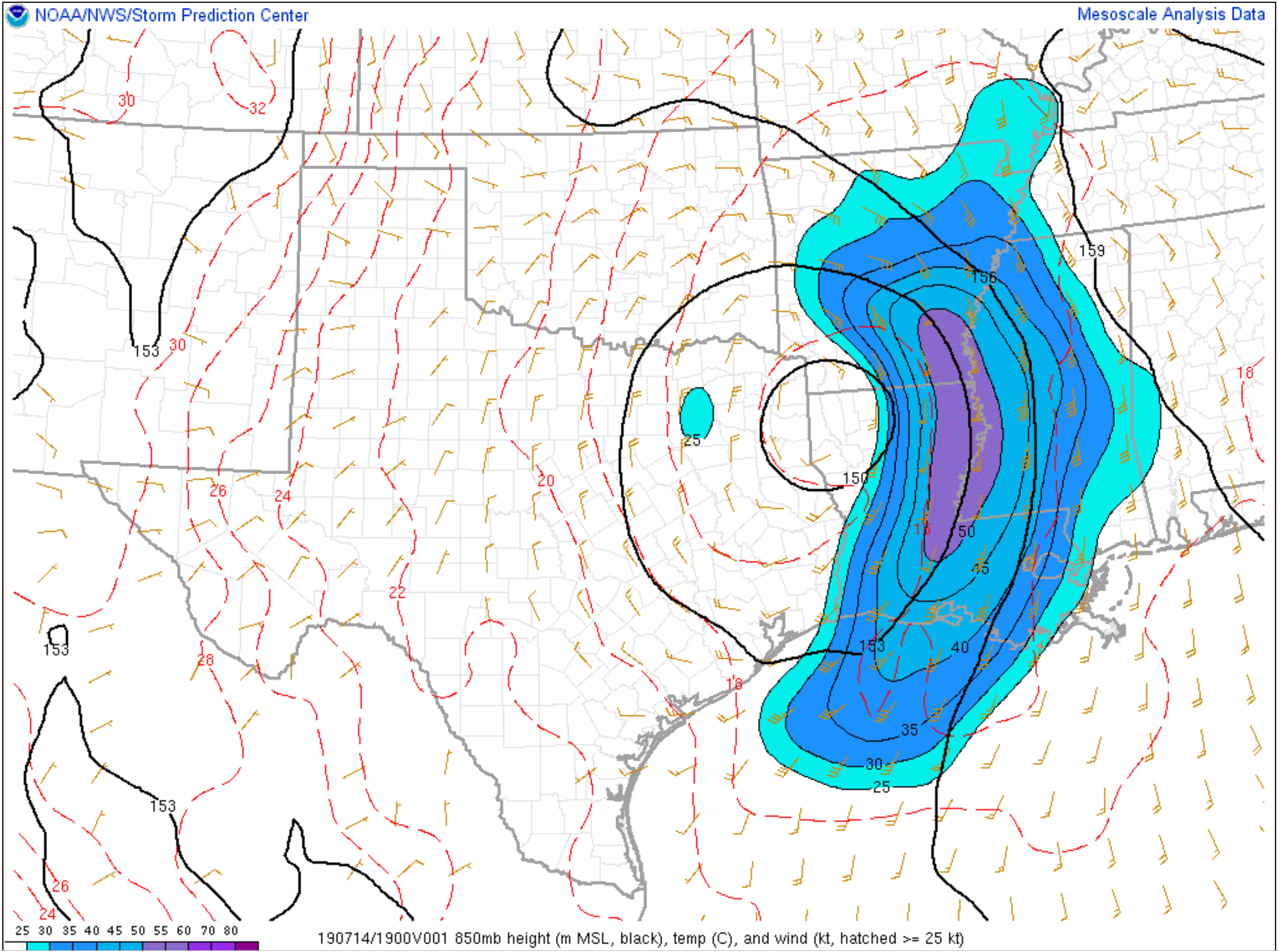
Storm Prediction Center meso-analysis indicates that most of the higher shear levels (see further down for an explanation of shear) remain well to our south.
With time, however, the shear will increase into our region. That is when the threat of damaging wind and tornadoes will increase.
Shear map. You can see the colors to our south. That is where wind shear is higher.
.
I have shifted the tornado risk a bit further north and east. This is mainly on Monday. I am watching Tuesday.
I am monitoring the Missouri Bootheel and northwest Tennessee for a tornado risk today and tonight.
These type of storms can move S to N and SE to NE. They are very difficult to issue warnings on. By the time a warning is issued the tornado may have lifted.
We should pay a bit more attention to weather conditions on Monday and perhaps even Tuesday.
.
11 AM Severe Weather and Flash Flood Update
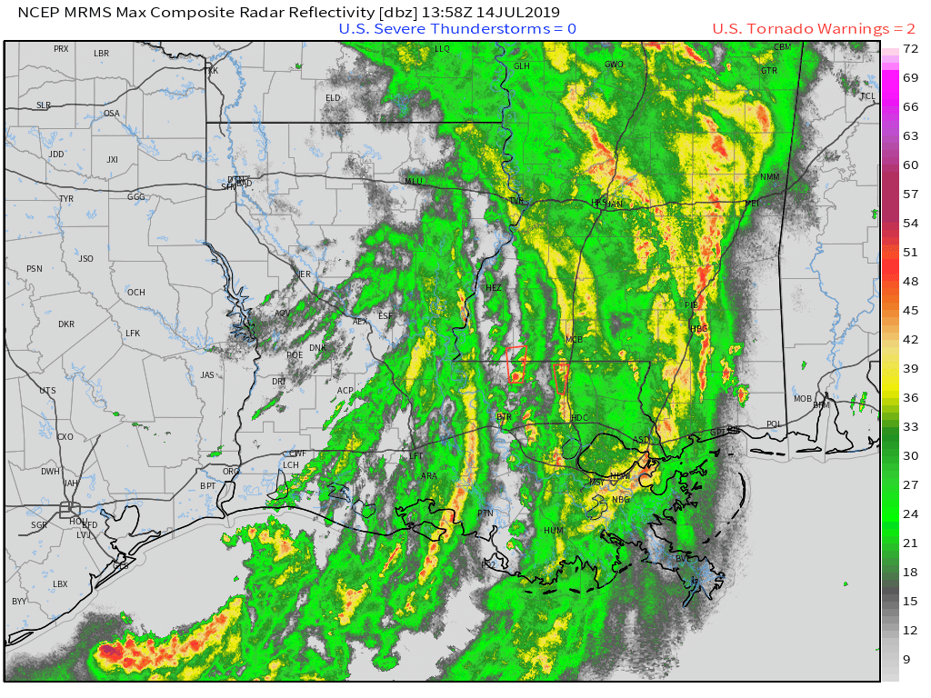
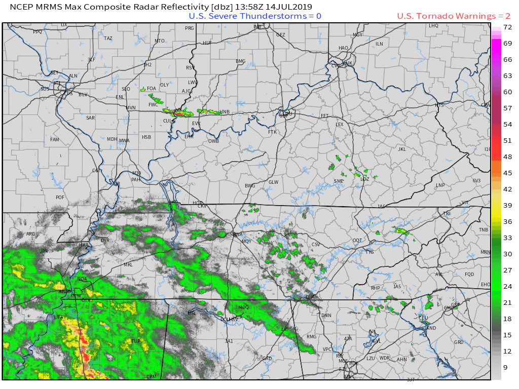
Sunday, July 14, 2019
** Portions of the region will receive flash flooding over the coming 72 hours **
** Isolated tornadoes are also possible **
I will keep this page updated with fresh information. I will use this same post today, tomorrow, and Tuesday.
Newest information will be posted here at the top of the page. You can scroll down to see previous posts.
.
KEY MESSAGE
- Try your best to use the Beau Dodson Weather App (vs the texts. Same messages but better delivery). The app receives the same messages but instantly. It is under Beau Dodson Weather in the app store.
- Feeder bands (bands) of showers and thunderstorms will push northward from the Gulf of Mexico today into Tuesday night.
- The heaviest showers/storms will produce rainfall totals of two to three inches per hour. This will enhance the flash flood threat.
- Some storms will rotate. Tropical systems are notorious for producing short-lived hard to warn on tornadoes. Monday and Tuesday will deliver the greatest chance of short-lived tornadoes.
.
Barry is moving northward. Here are two radar loops from Sunday morning. Notice the counter-clockwise spin. Precipitation will move in odd directions on your radars.
.
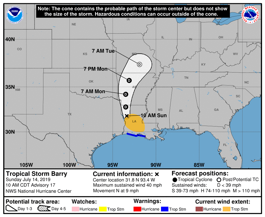
The National Hurricane Center tracks the center of Barry to our west.
Remember, the heaviest rain is to the right of the center. The tornado threat is to the right of the center, as well.
.
Definitions:
What is a feeder band? A feeder band is an arm of precipitation that usually moves southeast to northwest.
You will see that the radars appear to show precipitation spinning counter-clockwise. Why is that? Tropical systems are areas of low pressure. Low pressure rotates counter-clockwise.
When I use the word storm it could mean a tropical convective precipitation cell without lightning.
Tropical systems don't always produce lightning with their tornadic cells. Keep this in mind. You could have short-lived tornadoes without lightning.
When I say storms, keep that in mind.
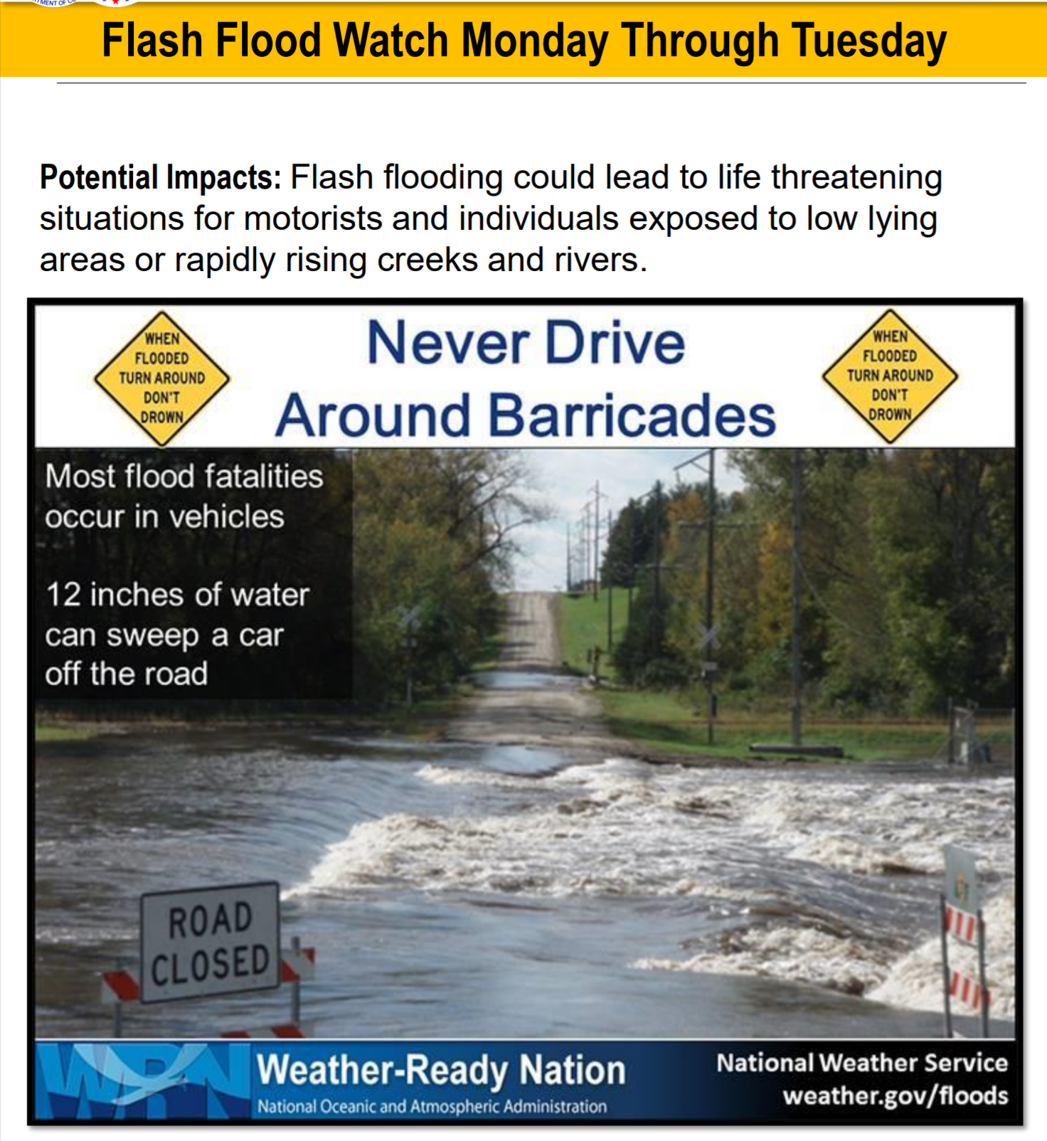
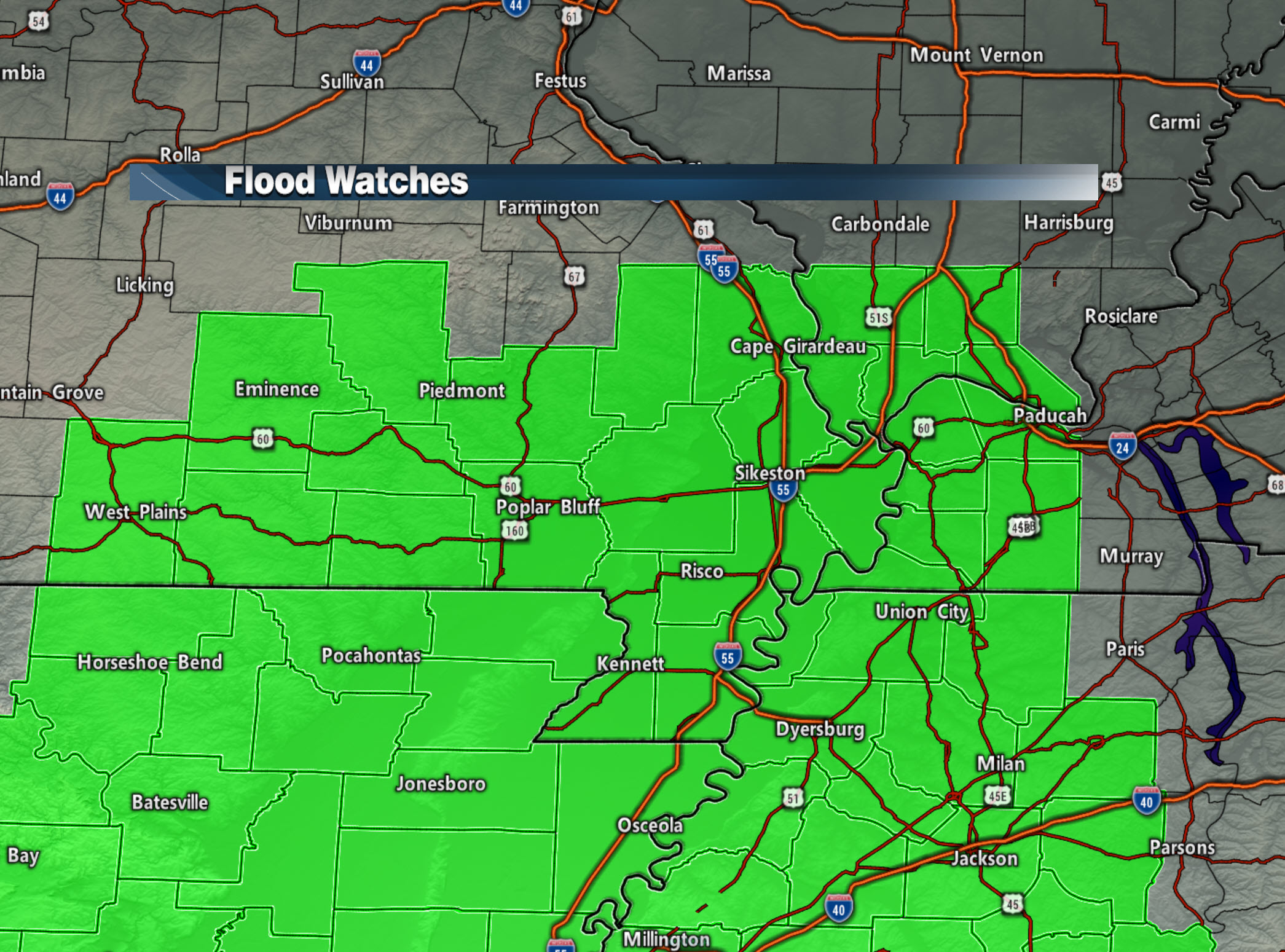
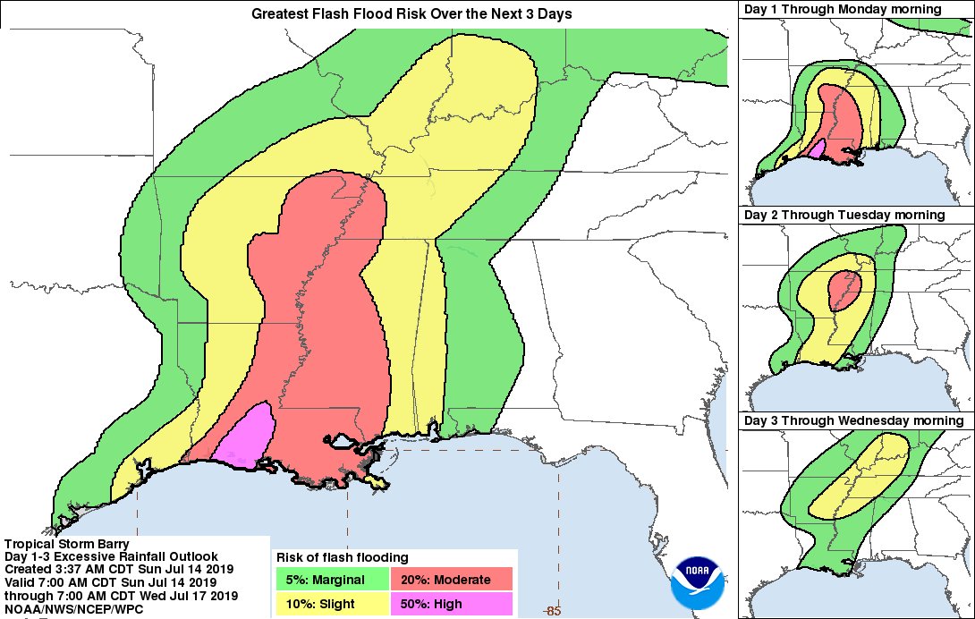
Currently, this is the area of greatest concern for flash flooding. As the system evolves there could be additional counties added to this flash flood watch.
The green zone is the flash flood watch.
.
Rainfall totals with tropical systems are a bit tricky.
There is going to be a bit of a broad-brush in totals. The heaviest amounts are currently forecast to be across southeast Missouri, far western Kentucky, and western Tennessee. Totals in these areas will likely range from two to four inches of rain. There can always be much higher totals.
Last night, for example, we had thunderstorms that produced more than two inches of rain in less than an hour in western Kentucky.
If a band of storms trains over the same area then excessive rainfall totals will occur. Excessive means more than four inches.
Totals elsewhere will likely range from 0.5" to 2.0".
Again, any shift in the feeder bands will mean a shift in the heaviest totals. Areas outside the flash flood watch can have heavy rain, as well.
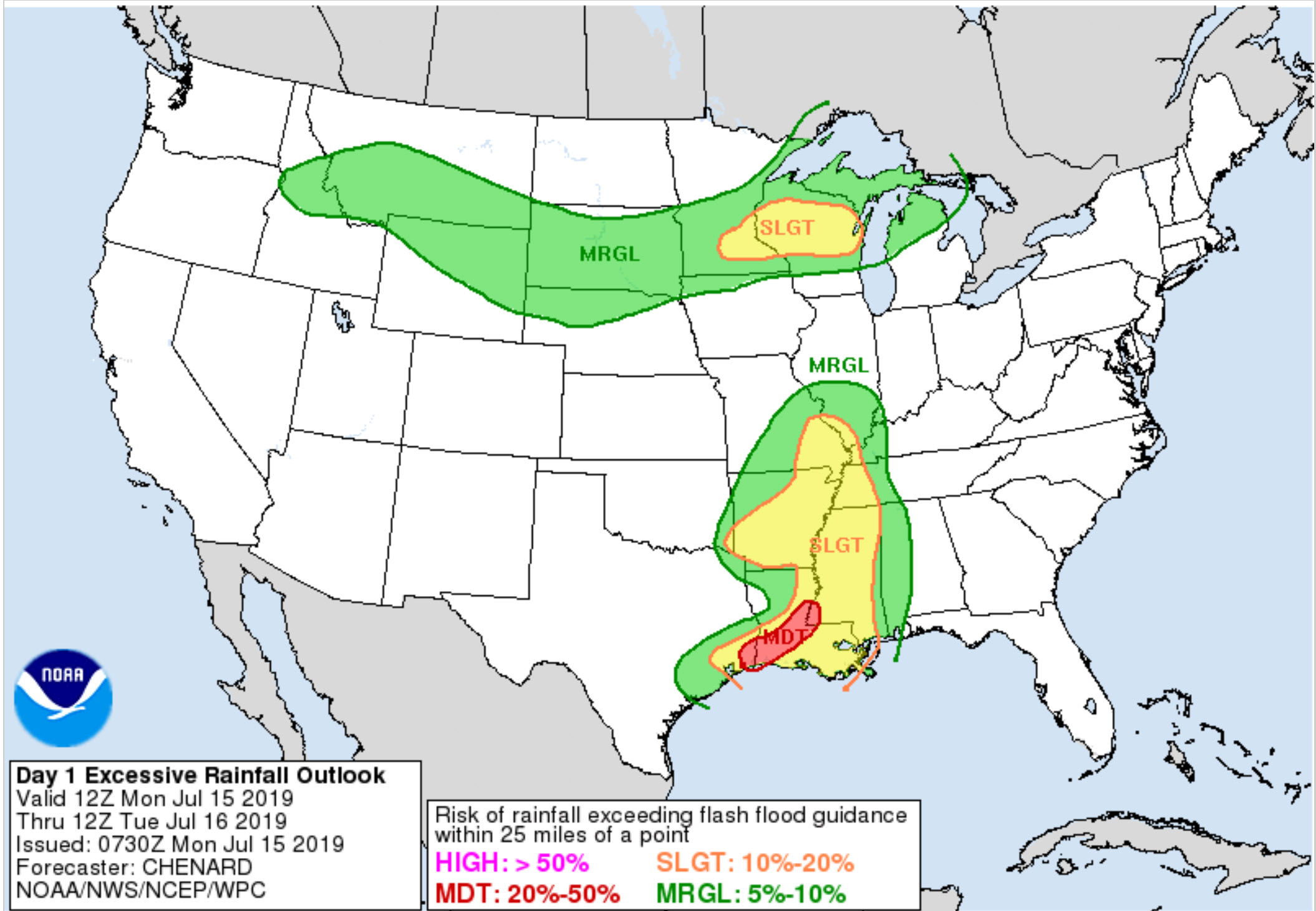
The WPC has placed our region in a risk of excessive rainfall. What does that mean? It means enough rain to trigger a flash flood warning.
The map on the left covers all three days. The maps on the right break it down day by day.
You can see the highest risk has currently been placed over the Missouri Bootheel into western Tennessee.
.
NOAA/WPC precipitation forecast.
Click all images to enlarge them.
.
This is the Canadian model.
.
This is the GFS model.
.
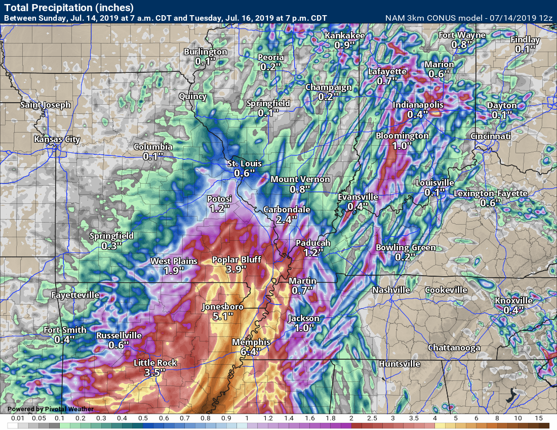
This is the high resolution NAM 3K model.
.
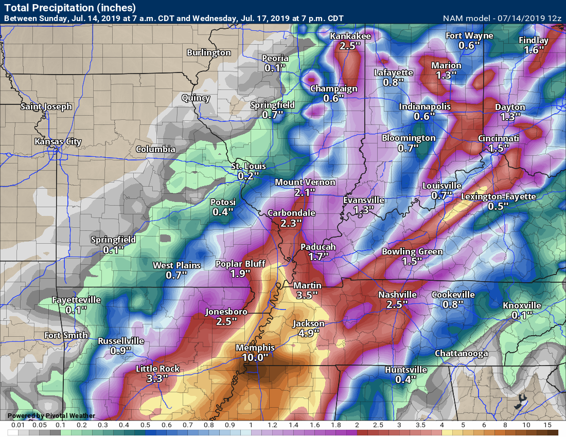
This is the NAM model.
.
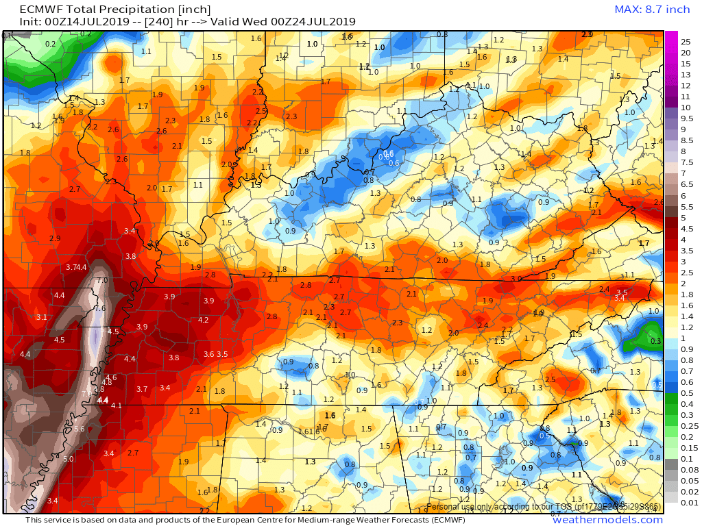
EC model guidance
.
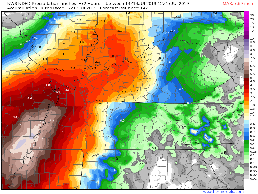
This is the NWS forecast rainfall totals.
.
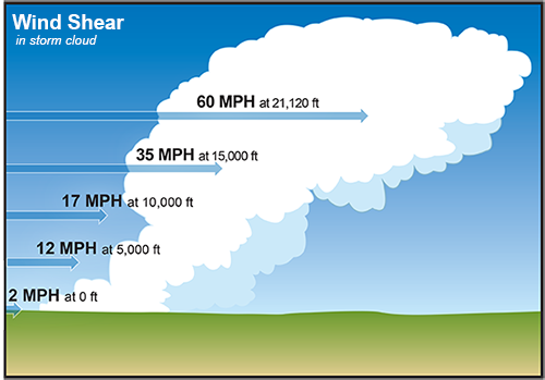
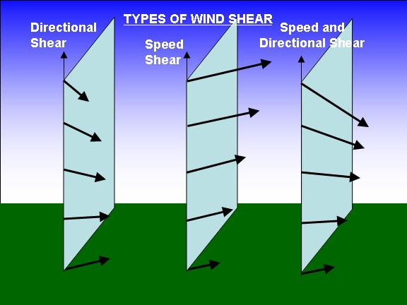
Wind shear will increase on Monday and Tuesday. What is wind shear? It is the turning of wind and/or speed with height. As you move from the ground upward you will notice a change in wind direction. You may notice a change of wind speed. This is shear.
Shear is one ingredient necessary for tornadoes to occur.
Tropical systems usually have quite a bit of wind shear.
.
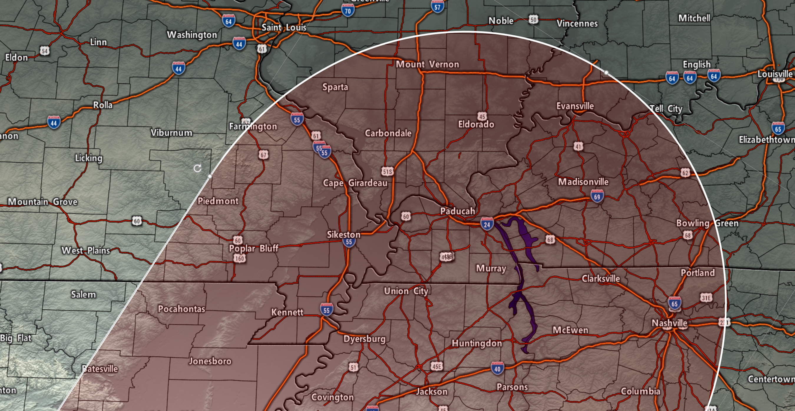
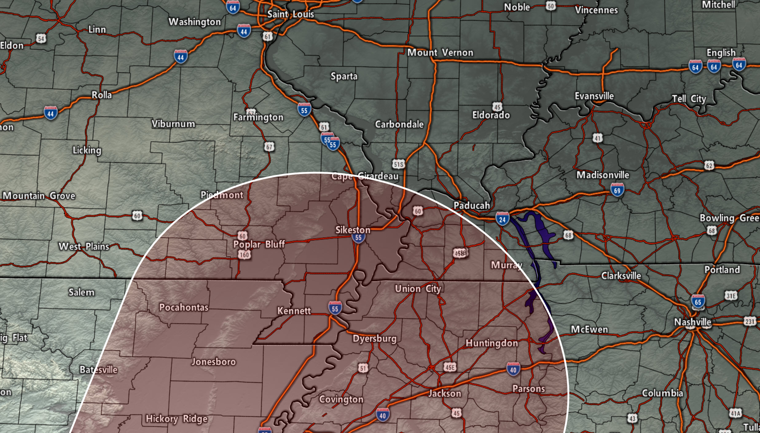
This is the area I am concerned about when it comes to the risk of short-lived tornadoes. Areas north and east of the red zone will also need to monitor updates.
The greatest time of concern will be Monday into Tuesday. The risk is higher if we have some breaks in the clouds and CAPE/instability can develop.
Click to enlarge the graphic.
.
.
Let's tale a look at some model future-cast radars. Keep in mind, these are models. They won't be exact. Take the general idea from them.
Click to enlarge each animation.
.
WRF model guidance
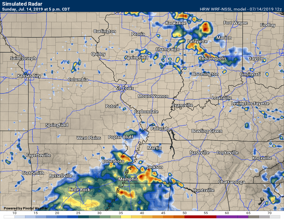
.
Hrrr model guidance
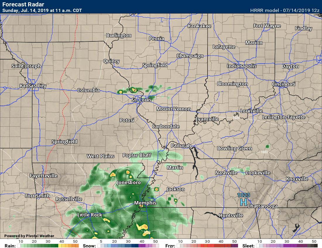
.
NAM model
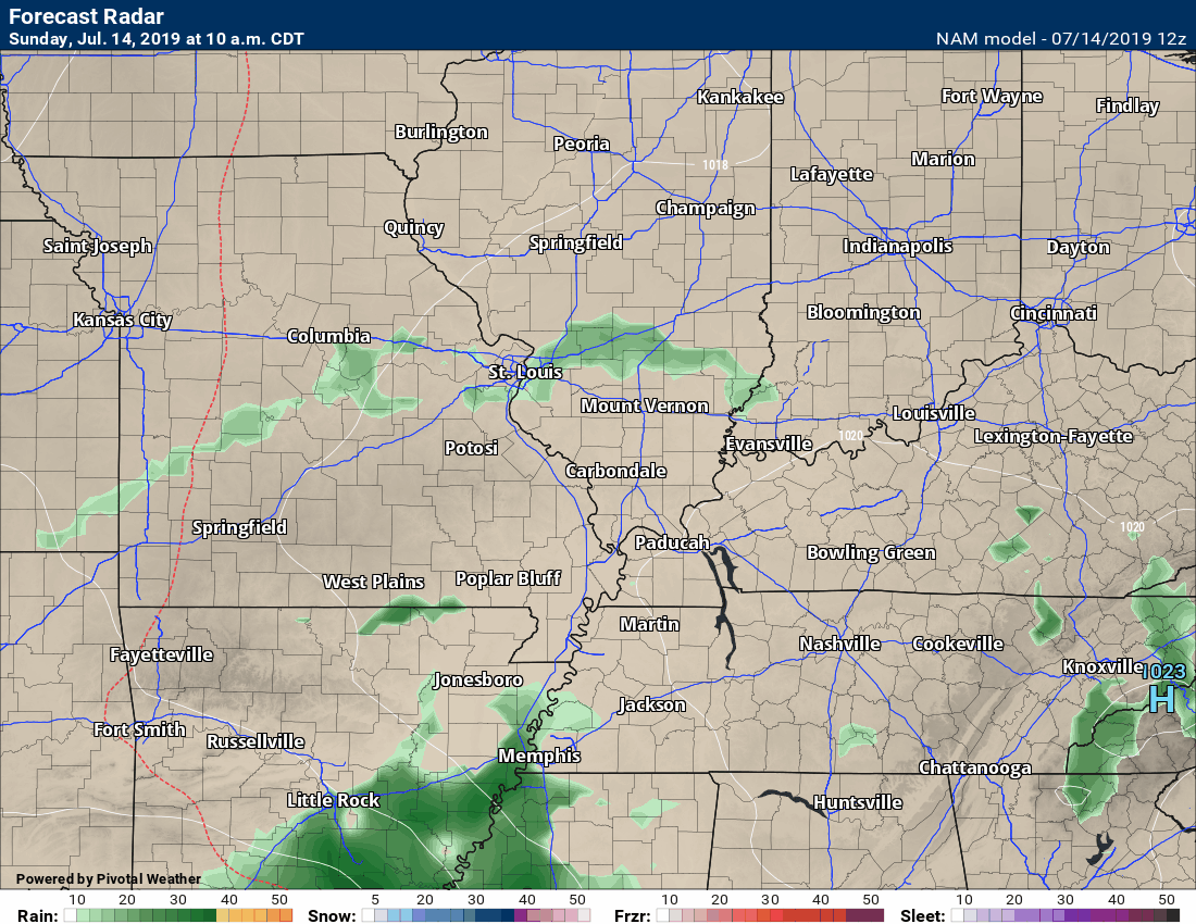
.
NAM 3K Model
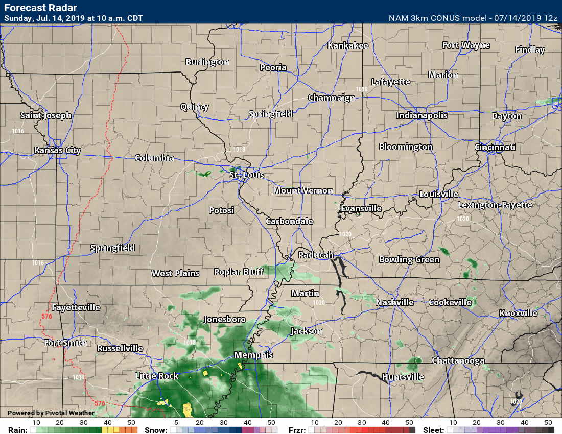
.
Bottom line:
The risk of heavy rain will increase over the coming 72 hours.
A few short-lived tornadoes are possible.
Monitor updates.
.
LIVE Radar Link: Interactive local city-view radars & regional radars.
.
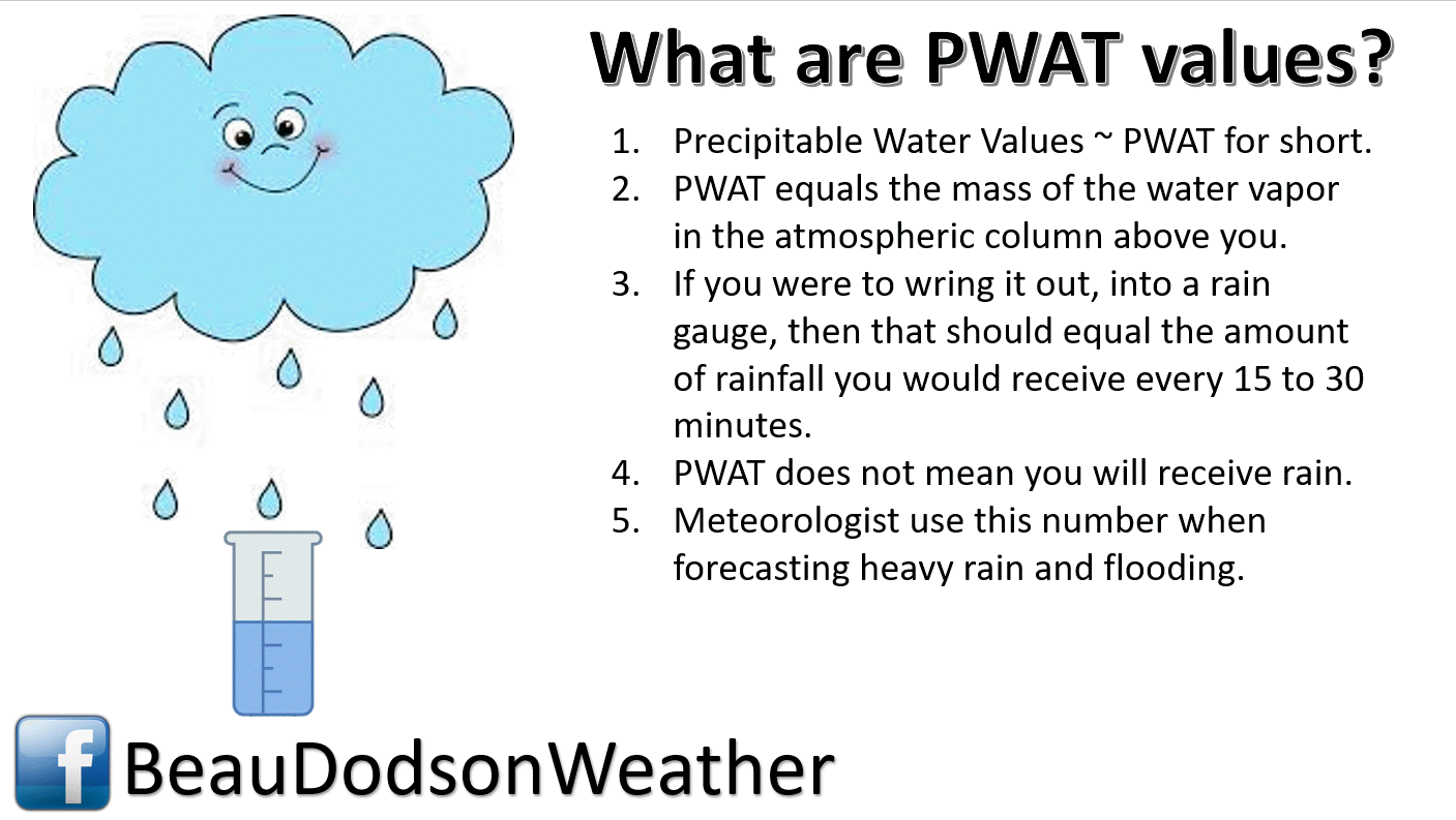
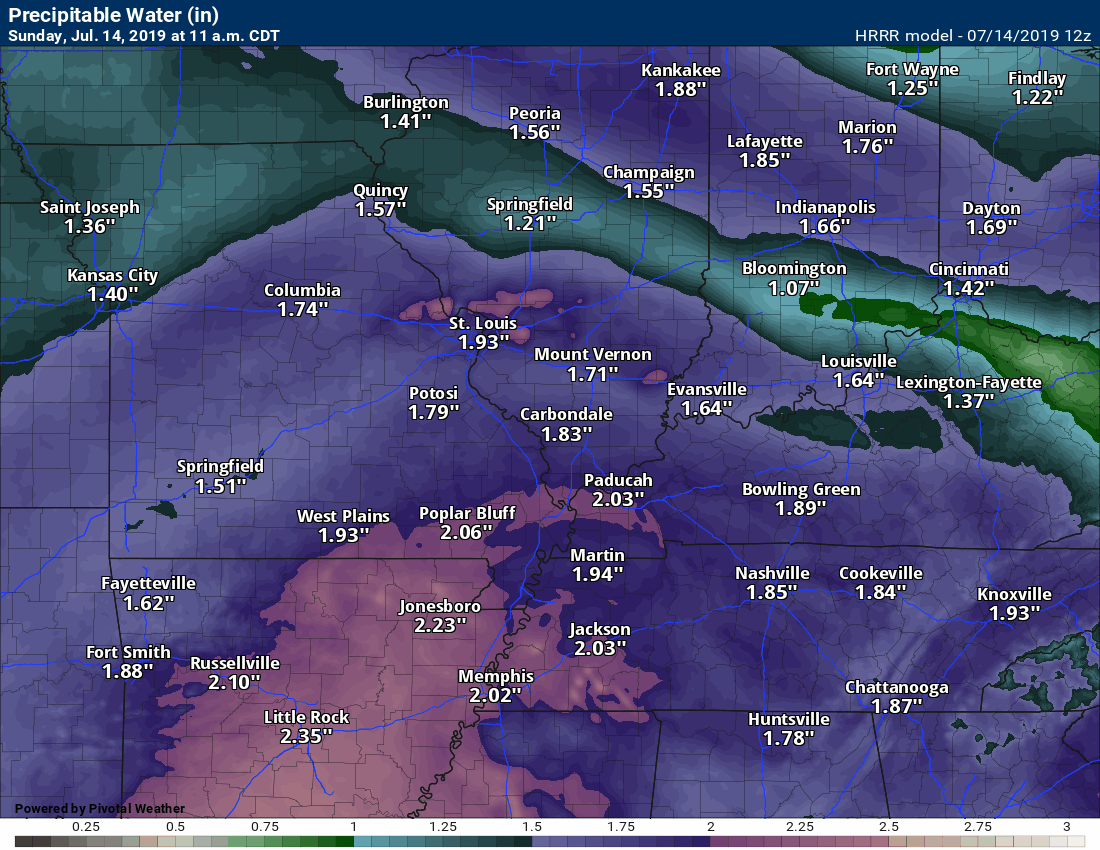
PWAT numbers are extremely high. Heavy rain will occur under any thunderstorms that form in our local area.
Higher PWAT numbers mean heavier rain.
.Click maps to enlarge.
This is the PWAT value map. Very high numbers in the dark green zone.
.
PWAT animation. Very high numbers moving northward with the tropical system. This is Gulf of Mexico moisture.
.
Today's SPC severe weather outlook (below).
Light green is where thunderstorms may occur but should be below severe levels.
Dark green is a level one risk. Yellow is a level two risk. Orange is a level three (enhanced) risk. Red is a level four (moderate) risk. Pink is a level five (high) risk.
One is the lowest risk. Five is the highest risk.
Light green is not assigned a number. Light green is where storms may occur but should be below severe levels.
A severe storm is one that produces 60 mph winds or higher, quarter size hail, and/or a tornado. One or more of those is defined as a severe thunderstorm.
.
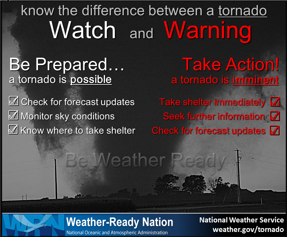
Remember, a watch means to go about your business and monitor updates. A warning means to move to a safe place of shelter until the storm passes.
.
.
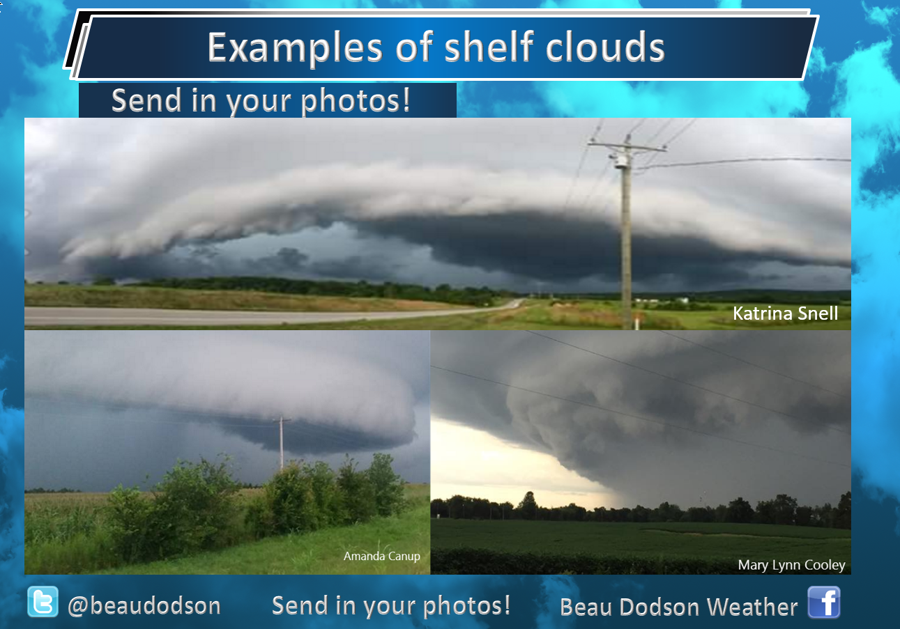
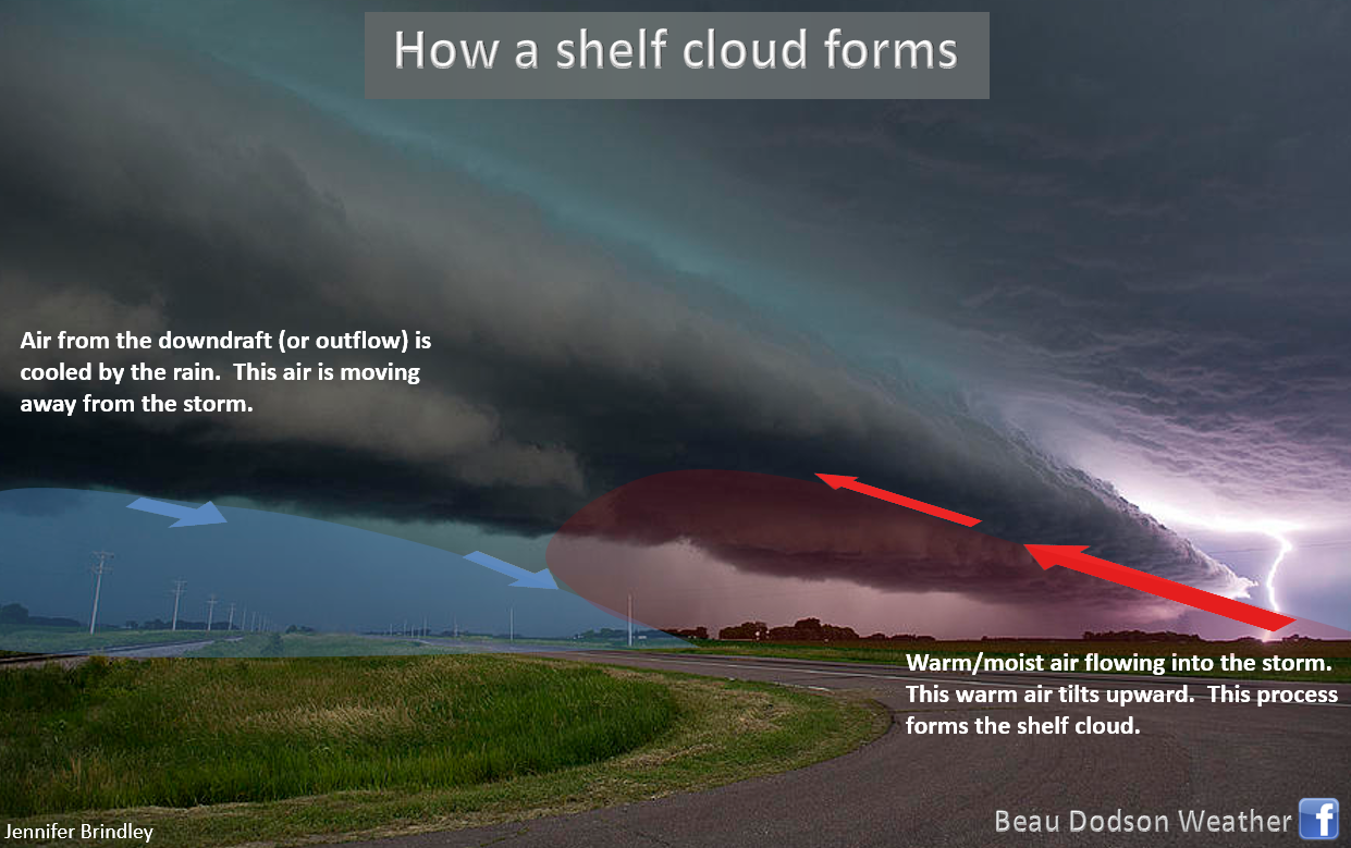
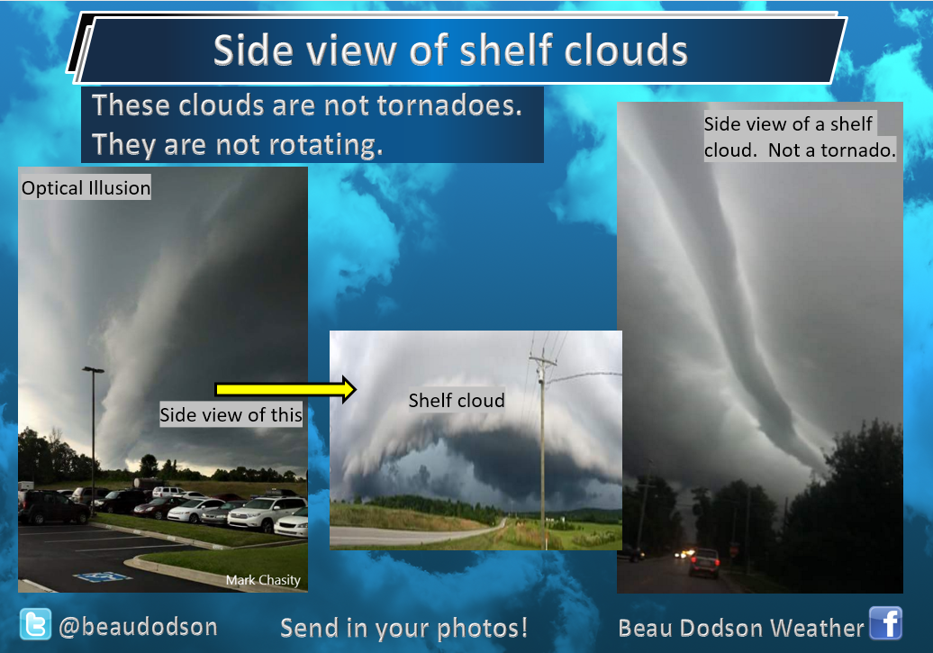
You will likely see a lot of shelf clouds today.
.
Additional storm tracking quick links
STORM TRACKING TOOLS
Interactive city-view radars
http://weatherobservatory.com/weather-radar.htm
Clickable watches and warnings can be viewed on the local city-view interactive radars (link above). Be sure and turn on the warnings above the local radars.
A new regional radar we offer
https://imagery.weathertalk.com/prx/RadarLoop.mp4
Lightning data
https://wtalk.co/7QT7WHKU
Watches/warnings
https://imagery.weathertalk.com/prx/SevereAlerts.png
Infrared satellite
https://imagery.weathertalk.com/prx/IRSatelliteLoop.mp4
Visible satellite
https://imagery.weathertalk.com/prx/GeocolorSatelliteLoop.mp4
Current conditions
https://imagery.weathertalk.com/prx/CurrentConditions.png
Current heat index or wind chill
https://imagery.weathertalk.com/prx/CurrentFeelsLike.png
Wind speed
https://imagery.weathertalk.com/prx/CurrentWindSpeed.png
Wind gust
https://imagery.weathertalk.com/prx/CurrentWindGust.png
Beau Dodson Weather App!
Have you downloaded the Beau Dodson Weather app?
Move to the app and do not depend on the text messages. The app receives the exact same messages but faster.
ATT and Verizon have been throttling the speed of texts.
The app receives them instantly.
Apple users: Beau Dodson Weather App
https://itunes.apple.com/us/app/id1190136514
Android users: Beau Dodson Weather App
https://play.google.com/store/apps/details?id=com.weathertalk.beaudodsonweather.android
..
Not receiving app/text messages?
Make sure you have the correct app/text options turned on. Find those under the personal notification settings tab at www.weathertalk.com. Red is off. Green is on.
Subscribers, PLEASE USE THE APP. ATT and Verizon are not reliable during severe weather. They are delaying text messages.
The app is under Beau Dodson Weather in the app store.

Apple users click here

Android users click here
.
.

.
.
Today's outlook (below).
Light green is where thunderstorms may occur but should be below severe levels.
Dark green is a level one risk. Yellow is a level two risk. Orange is a level three (enhanced) risk. Red is a level four (moderate) risk. Pink is a level five (high) risk.
One is the lowest risk. Five is the highest risk.
Light green is not assigned a number. Light green is where storms may occur but should be below severe levels.
A severe storm is one that produces 60 mph winds or higher, quarter size hail, and/or a tornado. One or more of those is defined as a severe thunderstorm.

The black outline is our local area.
.
Tomorrow's outlook.
Light green is where thunderstorms may occur but should be below severe levels.
Dark green is a level one risk. Yellow is a level two risk. Orange is a level three (enhanced) risk. Red is a level four (moderate) risk. Pink is a level five (high) risk.
One is the lowest risk. Five is the highest risk. Light green is not assigned a number.


.
.
Here is the latest graphic from the WPC/NOAA.
24-hour precipitation outlook.
.

.
48-hour precipitation outlook.
.
.
.
72-hour precipitation outlook.
.

.
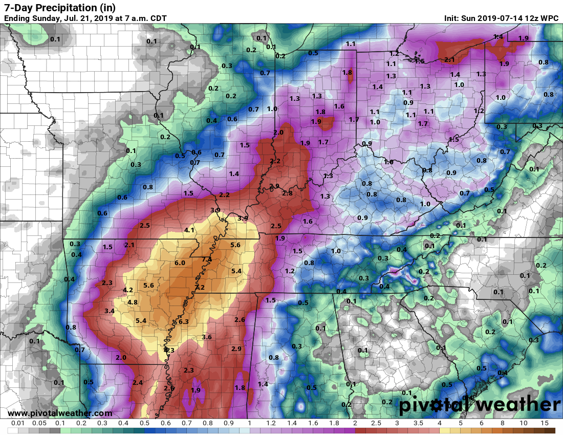
Days one through seven added together. Seven-day rainfall totals.

.
Radar Link: Interactive local city-view radars & regional radars.
You will find clickable warning and advisory buttons on the local city-view radars.
If the radar is not updating then try another one. If a radar does not appear to be refreshing then hit Ctrl F5. You may also try restarting your browser.
Not working? Email me at beaudodson@usawx.com
National map of weather watches and warnings. Click here.
Storm Prediction Center. Click here.
Weather Prediction Center. Click here.
.
Live lightning data: Click here.
.

Interactive GOES R satellite. Track clouds. Click here.
GOES 16 slider tool. Click here.
College of Dupage satellites. Click here
.

Here are the latest local river stage forecast numbers Click Here.
Here are the latest lake stage forecast numbers for Kentucky Lake and Lake Barkley Click Here.
.
Did you know that you can find me on Twitter? Click here to view my Twitter weather account.
.

.
Who do you trust for your weather information and who holds them accountable?
I have studied the weather in our region since the late 1970s. I have 40 years of experience in observing our regions weather patterns.
My degree is in Broadcast Meteorology from Mississippi State University and a Bachelor of Science (BS).
I am an NOAA Weather-Ready Nation Ambassador. I am the Meteorologist for McCracken County rescue squad. When asked, I assist Ballard and Massac Counties, as well.
I own and operate the Southern Illinois Weather Observatory and WeatherTalk LLC.
There is a lot of noise on the internet. Over time you should learn who to trust for your weather information.
My forecast philosophy is simple and straight forward.
- Communicate in simple terms
- To be as accurate as possible within a reasonable time frame before an event
- Interact with you on Twitter, Facebook, and the blog
- Minimize the “hype” that you might see on television or through other weather sources
- Push you towards utilizing wall-to-wall LOCAL TV coverage during severe weather events
I am a recipient of the Mark Trail Award, WPSD Six Who Make A Difference Award, Kentucky Colonel, and the Caesar J. Fiamma” Award from the American Red Cross.
In 2009 I was presented with the Kentucky Office of Highway Safety Award.
I was recognized by the Kentucky House of Representatives for my service to the State of Kentucky leading up to several winter storms and severe weather outbreaks.
If you click on the image below you can read the Kentucky House of Representatives Resolution.
.
.
Previous episodes can be viewed by clicking here.
.
Find Beau on Facebook! Click the banner.

.
Find Beau on Twitter! Share your weather photos! @beaudodson

.
Did you know that a portion of your monthly subscription helps support local charity projects? Not a subscriber? Becoming one at www.weathertalk.com
You can learn more about those projects by visiting the Shadow Angel Foundation website and the Beau Dodson News website.